MyTopo
Pharoah Oklahoma US Topo Map
Couldn't load pickup availability
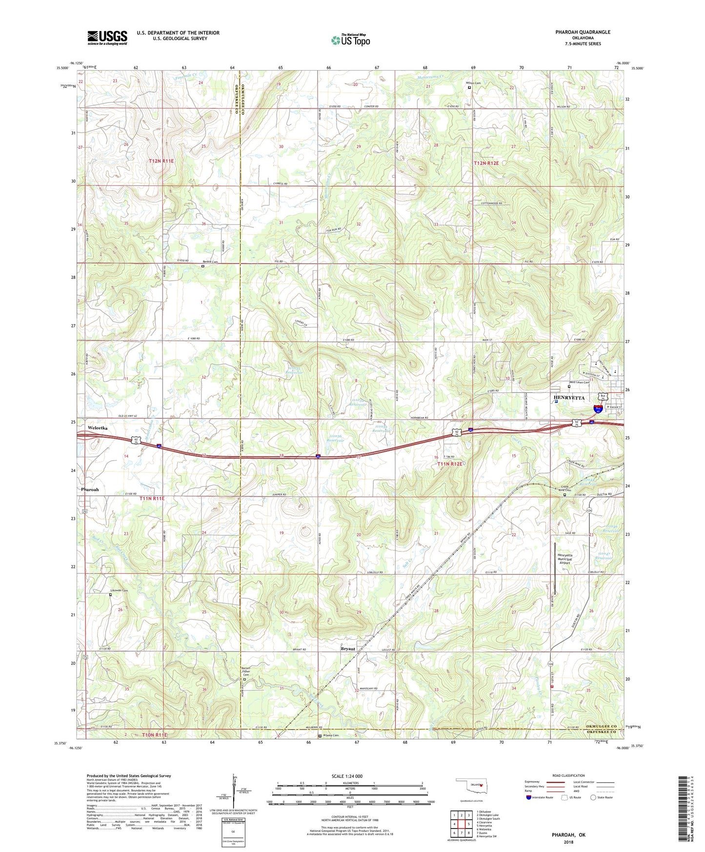
2022 topographic map quadrangle Pharoah in the state of Oklahoma. Scale: 1:24000. Based on the newly updated USGS 7.5' US Topo map series, this map is in the following counties: Okmulgee, Okfuskee. The map contains contour data, water features, and other items you are used to seeing on USGS maps, but also has updated roads and other features. This is the next generation of topographic maps. Printed on high-quality waterproof paper with UV fade-resistant inks.
Quads adjacent to this one:
West: Clearview
Northwest: Okfuskee
North: Okmulgee Lake
Northeast: Okmulgee South
East: Henryetta
Southeast: Henryetta SW
South: Dustin
Southwest: Weleetka
This map covers the same area as the classic USGS quad with code o35096d1.
Contains the following named places: Allen Church, Arbeka Cemetery, Arbeka Church, Aztec Church, Barnet - Fisher Cemetery, Bryant, Bryant Census Designated Place, Bryant Oil Field, Creek Mine Cemetery, Henryetta Elementary School, Henryetta High School, Henryetta Medical Center, Henryetta Middle School, Henryetta Municipal Airport, Henryetta Oil and Gas Field, Likowski Cemetery, Lyons-Quinn Oil and Gas Field, Oknoname 107029 Dam, Oknoname 107029 Reservoir, Oknoname 111033 Dam, Oknoname 111033 Reservoir, Oknoname 111034 Dam, Oknoname 111034 Reservoir, Oknoname 111035 Dam, Oknoname 111035 Reservoir, Oknoname 111036 Dam, Oknoname 111036 Reservoir, Oknoname 111044 Dam, Oknoname 111044 Reservoir, Oknoname 111046 Dam, Oknoname 111046 Reservoir, Oknoname 111047 Dam, Oknoname 111047 Reservoir, Oknoname 111051 Dam, Oknoname 111051 Reservoir, Oknoname 111052 Dam, Oknoname 111052 Reservoir, Oknoname 111054 Dam, Oknoname 111054 Reservoir, Pharoah, Plainview Volunteer Fire Department, Renkie Cemetery, Southeast Bryant Oil and Gas Field, West Lawn Cemetery, Wilson Cemetery, ZIP Code: 74880