MyTopo
Emigrant Lake Oregon US Topo Map
Couldn't load pickup availability
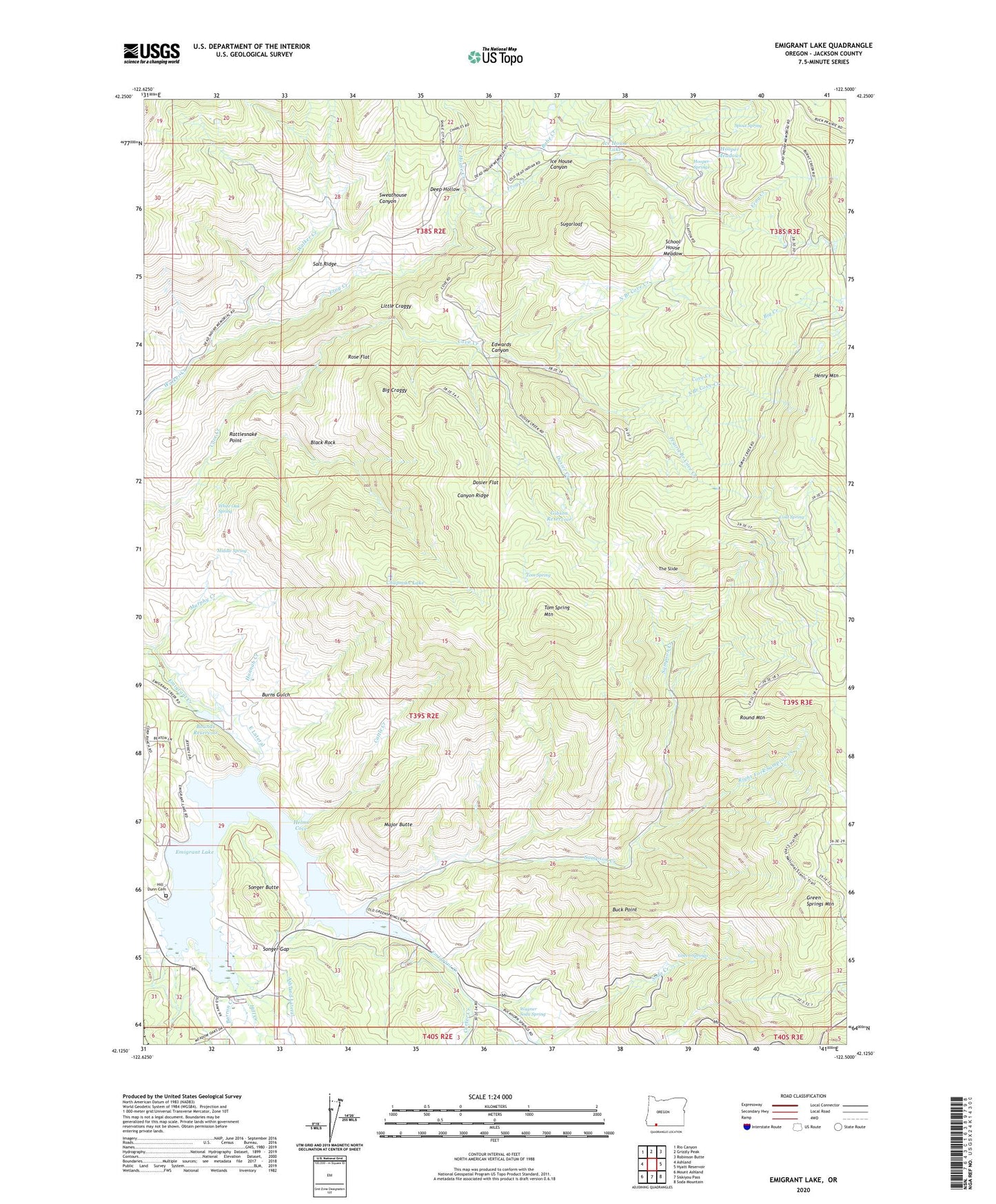
2024 topographic map quadrangle Emigrant Lake in the state of Oregon. Scale: 1:24000. Based on the newly updated USGS 7.5' US Topo map series, this map is in the following counties: Jackson. The map contains contour data, water features, and other items you are used to seeing on USGS maps, but also has updated roads and other features. This is the next generation of topographic maps. Printed on high-quality waterproof paper with UV fade-resistant inks.
Quads adjacent to this one:
West: Ashland
Northwest: Rio Canyon
North: Grizzly Peak
Northeast: Robinson Butte
East: Hyatt Reservoir
Southeast: Soda Mountain
South: Siskiyou Pass
Southwest: Mount Ashland
This map covers the same area as the classic USGS quad with code o42122b5.
Contains the following named places: Acey Field, Ashland Lateral, Babe Creek, Barron, Barron Creek, Barron Mine, Barron Post Office, Big Craggy, Big Creek, Big Prairie, Bill Willis Flats, Black Rock, Bounds Reservoir, Buck Point, Burns Gulch, Canyon Ridge, Carter Creek, Cattle Creek, Chapman Lake, Cold Spring, Cove Ranch, Deep Hollow, Dosier Creek, Dosier Flat, Edwards Canyon, Emigrant Channel, Emigrant Dam, Emigrant Lake, Emigrant Lake County Park, Emigrant Lake Jackson County Boat Ramp North, Emigrant Lake Jackson County Boat Ramp West, Frog Creek, Gibson Reservoir, Green Springs, Green Springs Mountain, Hannah Creek, Helms Cove, Henry Mountain, Henry Ranch, Hill - Dunn Cemetery, Hill Creek, Hooper Meadows, Hooper Springs, Hooper Springs County Wayside, Ice House Canyon, Ice House Creek, Ice House Lake, Keno Rural Fire Protection District Station 4, Klamath Junction, Little Craggy, Little Prairie, Major Butte, Middle Ridge, Middle Spring, Murphy Creek, North Branch Cove Creek, Prairie Branch Cove Creek, Rattlesnake Point, Right Fork Sampson Creek, Rose Flat, Round Mountain, Salt Ridge, Sampson Creek, School House Meadow, Soda Creek, Songer Butte, Songer Gap, Songer Wayside, Songer Wayside Jackson County Boat Launch, South Branch Cove Creek, Spout Spring, Sugarloaf, Sweathouse Canyon, The Slide, Tom Spring, Tom Spring Mountain, Wagner Soda Spring, Wagner Springs, Walker Sheep Camp, White Oak Spring, ZIP Code: 97520