MyTopo
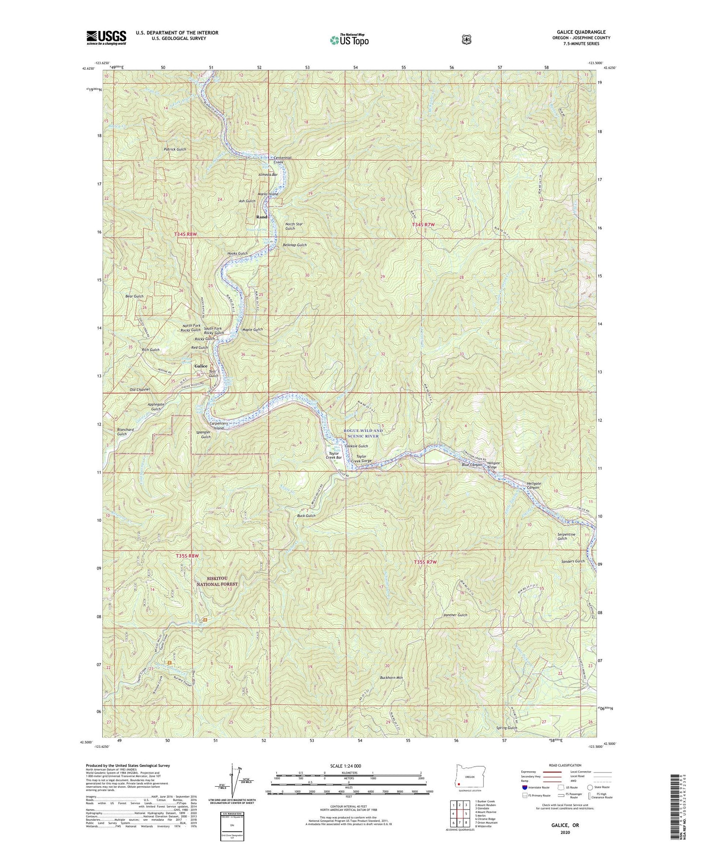
Galice Oregon US Topo Map
Couldn't load pickup availability
Also explore the Galice Forest Service Topo of this same quad for updated USFS data
2023 topographic map quadrangle Galice in the state of Oregon. Scale: 1:24000. Based on the newly updated USGS 7.5' US Topo map series, this map is in the following counties: Josephine. The map contains contour data, water features, and other items you are used to seeing on USGS maps, but also has updated roads and other features. This is the next generation of topographic maps. Printed on high-quality waterproof paper with UV fade-resistant inks.
Quads adjacent to this one:
West: Mount Peavine
Northwest: Bunker Creek
North: Mount Reuben
Northeast: Glendale
East: Merlin
Southeast: Wilderville
South: Onion Mountain
Southwest: Chrome Ridge
This map covers the same area as the classic USGS quad with code o42123e5.
Contains the following named places: Almeada Bar Boat Ramp, Almeda, Almeda Bar, Almeda County Park, Almeda Mine, Almeda Post Office, Applegate Gulch, Argo County Park, Argo Creek, Argo Riffle, Armedio Riffle, Ash Gulch, Bailey Creek, Bear Gulch, Belknap Gulch, Black Bear Mine, Blanchard Gulch, Blue Canyon, Buck Gulch, Buckhorn Mountain, Burned Timber Creek, Carpenters Island, Carpenters Island Park, Centennial Gulch, Chair Riffle, Coffee Pot Trail, Cold Springs Creek, Cooksie Gulch, Delta Creek, Dunn Riffle, Ennis Riffle, Ennis Riffle Boat Ramp, Ennis Riffle County Park, Fraser Spring, Friday Spring, Galice, Galice Boat Landing, Galice Creek, Galice Post Office, Galice Riffle, Golden Wedge Mine, Hellgate Bridge, Hellgate Canyon, Hog Creek, Hog Creek Boat Ramp, Hog Creek County Park, Hooks Gulch, Indian Mary County Park, Indian Mary Park Boat Ramp, Keyte Creek, Little Stratton Creek, Little Zigzag Creek, Lower Galice Riffle, Maple Gulch, Marks Island, Mouse Creek, North Fork Rocky Gulch, North Star Gulch, Old Channel Mine, Old Man Riffle, Oriole Mine, Paint Creek, Patrick Gulch, Phipps Creek, Rand, Rand Access Boat Launch, Rand Ranger Station, Rand Recreation Area, Red Gulch, Rich Gulch, Rocky Gulch, Rocky Riffle, Schoolmarm Creek, Serpentine Gulch, Seven-Thirty Mine, Smith Creek, South Fork Argo Creek, South Fork Galice Creek, South Fork Rocky Gulch, Spangler Gulch, Spring Gulch, Stratton Creek, Taylor Creek, Taylor Creek Bar, Taylor Creek Gorge, Taylor Gorge Overlook, Tin Can Recreation Site, Toss Gulch, Upper Galice Riffle, Waterspout Creek, Yew Wood Creek, Zigzag Creek, ZIP Code: 97532