MyTopo
Glendale Oregon US Topo Map
Couldn't load pickup availability
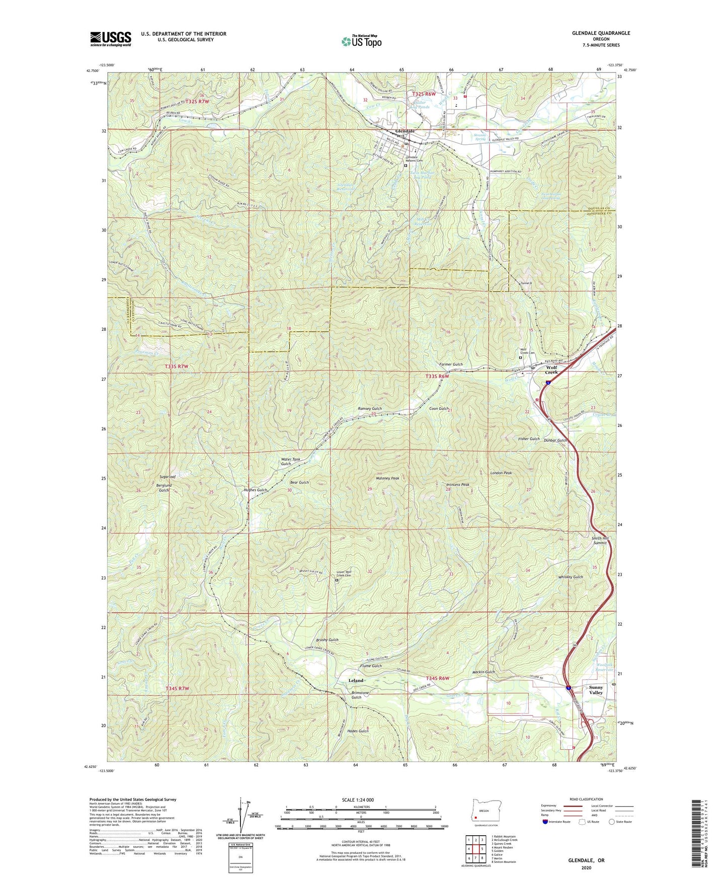
2020 topographic map quadrangle Glendale in the state of Oregon. Scale: 1:24000. Based on the newly updated USGS 7.5' US Topo map series, this map is in the following counties: Josephine, Douglas. The map contains contour data, water features, and other items you are used to seeing on USGS maps, but also has updated roads and other features. This is the next generation of topographic maps. Printed on high-quality waterproof paper with UV fade-resistant inks.
Quads adjacent to this one:
West: Mount Reuben
Northwest: Rabbit Mountain
North: McCullough Creek
Northeast: Quines Creek
East: Golden
Southeast: Sexton Mountain
South: Merlin
Southwest: Galice
Contains the following named places: Altamont Post Office, Aman Ranch Placer, Angora Creek, Applegate Trail Interpretive Center Museum, Bear Gulch, Brimstone Gulch, Brushy Gulch, Cedar Creek, Cindy Creek, City of Glendale, City of Glendale Ambulance Service, Coon Gulch, Coyote Creek, Dog Creek, Dollar Log Ponds, Dunbar Gulch, Ehlig Reservoir, Farmer Gulch, Fisher Gulch, Flume Gulch, Fort Bailey, Fort Leland, Gledale Public Works, Glendale, Glendale Baptist Church, Glendale Branch Library, Glendale City Hall, Glendale Elementary School, Glendale High School, Glendale Justice Court, Glendale Masonic Cemetery, Glendale Municipal Court, Glendale Post Office, Glendale Reservoir, Glendale Rural Fire Protection District, Glendale Wastewater Treatment Plant, Glendale Water Treatment Plant, Glory Hole Placer, Goff Placer, Hades Gulch, Hughes Gulch, Japanese Creek, Laundry Creek, Leland, Leland Post Office, London Peak, Lower Wolf Creek Cemetery, Lystul, Mackin Gulch, Maloney Peak, McCullough Creek, Mill Creek, Mill Creek Reservoir, Mount Creek, Olivet Presbyterian Church, Perkins Creek, Pollard, Princess Peak, Ramsey Gulch, Rat Creek, Rattlesnake Creek, Reuben, Reuben Post Office, Right Fork Rat Creek, Rowes Post Office, Rural / Metro Fire Department Station 3, Salmon Creek, Section Creek, Smith Hill Summit, Steam Beer Placer, Stevens Creek, Stranns Spring, Sugarloaf, Sunny Valley, Sunny Valley Post Office, Sunny Wolf Charter School, Superior Log Pond, Tom East Creek, Totten, Totten Creek, Tuff, Tunnel 8, Tunnel Creek, Twin Harbor Log Pond, Twin Harbor Loop Spring, Water Tank Gulch, Whiskey Gulch, Windy Creek, Wolf Creek, Wolf Creek Cemetery, Wolf Creek County Park, Wolf Creek Inn State Park, Wolf Creek Pools, Wolf Creek Post Office, Wolf Creek Rural Fire Protection District, Woolfolk Reservoir, ZIP Code: 97497