MyTopo
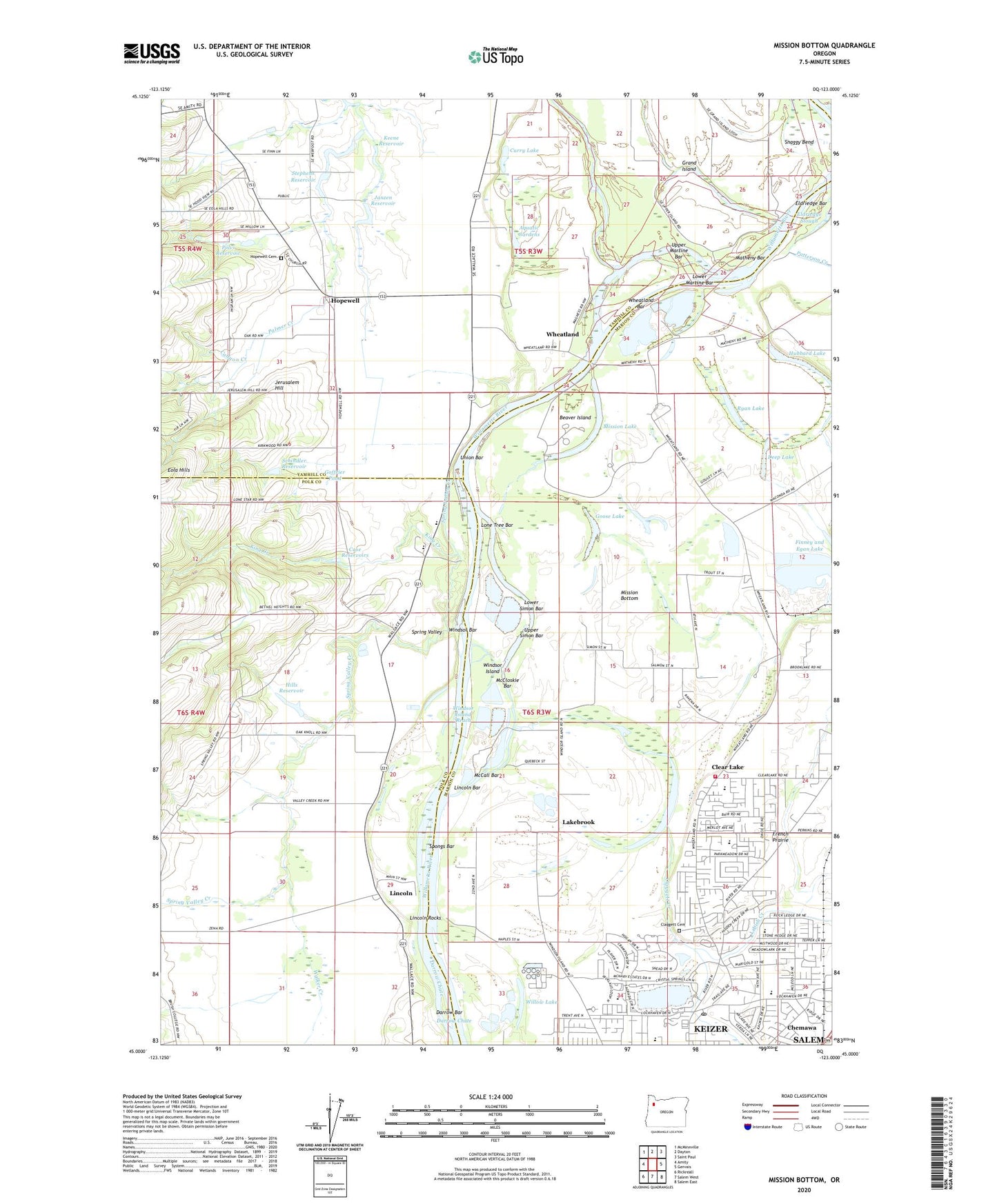
Mission Bottom Oregon US Topo Map
Couldn't load pickup availability
2024 topographic map quadrangle Mission Bottom in the state of Oregon. Scale: 1:24000. Based on the newly updated USGS 7.5' US Topo map series, this map is in the following counties: Marion, Yamhill, Polk. The map contains contour data, water features, and other items you are used to seeing on USGS maps, but also has updated roads and other features. This is the next generation of topographic maps. Printed on high-quality waterproof paper with UV fade-resistant inks.
Quads adjacent to this one:
West: Amity
Northwest: McMinnville
North: Dayton
Northeast: Saint Paul
East: Gervais
Southeast: Salem East
South: Salem West
Southwest: Rickreall
This map covers the same area as the classic USGS quad with code o45123a1.
Contains the following named places: Aquatic Gardens, Beaver Island, Canyon Creek, Case Reservoirs, Chemawa BPA Spur, Chemawa Station, City of Keizer, Claggett Cemetery, Claggett Creek, Clear Lake, Clear Lake Boat Ramp, Clear Lake Elementary School, Clear Lake Golf Course, Curry Lake, Darrow Bar, Darrow Chute, Deep Lake, Ediger Landing County Park Boat Ramp, Eldriedge Bar, Eldriedge Landing, Eola Hills, Finney Lake Airport, Forest Ridge Elementary School, Goffrier Pond, Goose Lake, Gubser Elementary School, Hills Reservoir, Hopewell, Hopewell Cemetery, Hopewell Post Office, Hubbard Lake, Janzen Reservoir, Jason Lee Mission Historical Marker, Jerusalem Hill, Keene Dam, Keene Reservoir, Keizer Elementary School, Keizer Post Office, King Creek, Labish Creek, Lakebrook, Lincoln, Lincoln Bar, Lincoln Post Office, Lincoln Rocks, Lone Tree Bar, Lower Martine Bar, Lower Simon Bar, Marion County Fire District 1 Station 6 Wheatland, Matheny Bar, Maud Williamson State Park, McCall Bar, McCloskie Bar, McNary High School, Migrant Primary School, Mission Bottom, Mission Lake, Northridge Park, Northside County Park, Nygren Reservoir, Optimum Learning Environment Charter School, Patterson Creek, Pine Tree Corner, Polvi Reservoir, Quinaby, Ryan Lake, Salem Public Works Department Willow Lake Office, Salem Willow Lake Wastewater Treatment Facility, Schindler Reservoir, Simon Landing, Snaggy Bend, Spongs Bar, Spongs Landing, Spongs Landing County Park, Spring Valley, Spring Valley Community Center, Spring Valley Creek, Spring Valley Post Office, Stephens Farm, Stephens Reservoir, Tompkins Landing, Union Bar, Upper Martine Bar, Upper Simon Bar, Valfontis Post Office, Walker Creek, Western Mennonite School, Wheatland, Wheatland Bar, Wheatland Dam, Wheatland Ferry, Wheatland Ferry Landing East, Wheatland Ferry Landing West, Wheatland Post Office, Whiteaker Middle School, Wilark County Park, Willamette Mission State Park, Willamette Mission State Park Boat Ramp, Willamette Mission State Park Mission Lake Boat Ramp, Willow Lake, Windsor Bar, Windsor Island, Windsor Island Reach, ZIP Codes: 97303, 97304