MyTopo
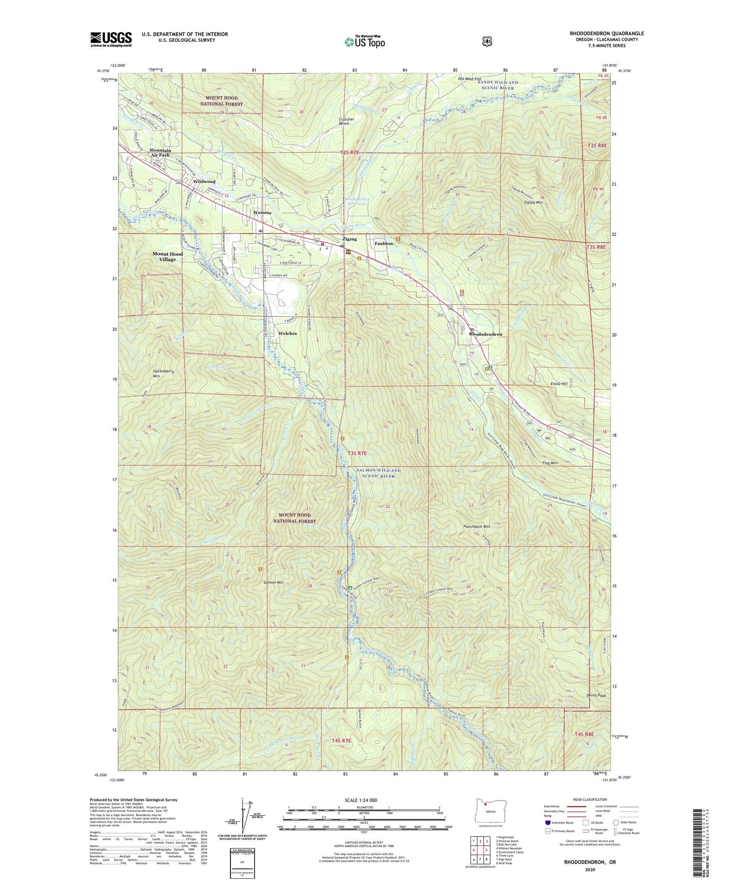
Rhododendron Oregon US Topo Map
Couldn't load pickup availability
Also explore the Rhododendron Forest Service Topo of this same quad for updated USFS data
2024 topographic map quadrangle Rhododendron in the state of Oregon. Scale: 1:24000. Based on the newly updated USGS 7.5' US Topo map series, this map is in the following counties: Clackamas. The map contains contour data, water features, and other items you are used to seeing on USGS maps, but also has updated roads and other features. This is the next generation of topographic maps. Printed on high-quality waterproof paper with UV fade-resistant inks.
Quads adjacent to this one:
West: Wildcat Mountain
Northwest: Brightwood
North: Hickman Butte
Northeast: Bull Run Lake
East: Government Camp
Southeast: Wolf Peak
South: High Rock
Southwest: Three Lynx
This map covers the same area as the classic USGS quad with code o45121c8.
Contains the following named places: AJ Dwyer Roadside Reservation Memorial Area, Arrah Wanna Trail, Bear Creek, Bighorn Campground, Bighorn Creek, Bonanza Trail, Caldwell Creek, Camp Arrah Wanna, Camp Creek, Cheeney Creek, Clackamas County Hoodland Wastewater Treatment, Clear Creek, Clear Creek Campground, Coffman Camp Trail, Cool Creek, Copper Creek, Crutcher Bench, Devils Peak, Enola Hill, Faubion, Faubion Post Office, Fern Creek, Flag Mountain, Flag Mountain Trail, Green Canyon Recreation Site, Henry Creek, Henry Creek Reservoir, Hoodland Branch Library, Hoodland Fire District 74 Main Station, Hoodland Park, Hoodland Plaza Shopping Center, Horseshoe Creek, Hunchback Mountain, Hunchback Mountain Trail, Katy Creek, Kloshe Chuck Reservoir, Little Cheney Creek, Long Creek, Lost Creek, Lymp Creek, Lymp Reservoir, Mack Hall Creek, Minikahda Creek, Mount Hood Division, Mount Hood Information Center, Mount Hood Village, Mount Hood Villages Census Designated Place, Mountain Air Park, Rhododendron, Rhododendron Census Designated Place, Rhododendron Post Office, Rockwood Creek, Rolling Riffle Campground, Salmon Mountain, Salmon Mountain Trail, Salmon River Guard Station, Salmon-Huckleberry Wilderness, South Fork Campground, South Fork Salmon River, Still Creek, Tawney, The Courses, Tollgate Campground, Tollgate Recreation Site, Welches, Welches Creek, Welches Elementary School, Welches Middle School, Welches Post Office, Wemme, Wemme Post Office, West Zigzag Lookout, West Zigzag Mountain Trail, Wildwood, Wildwood Recreation Site, Zigzag, Zigzag Post Office, Zigzag Ranger Station, Zigzag River, Zigzag River Campground