MyTopo
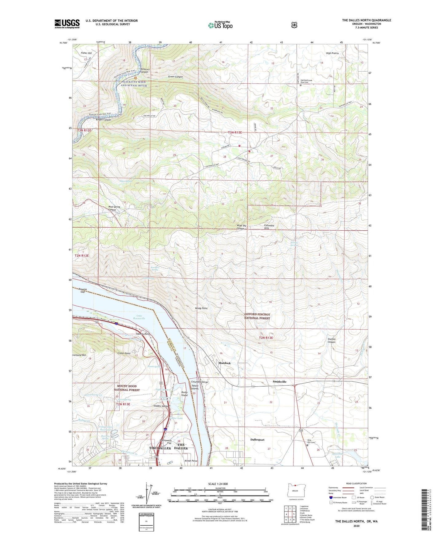
The Dalles North Oregon US Topo Map
Couldn't load pickup availability
Also explore the The Dalles North Forest Service Topo of this same quad for updated USFS data
2024 topographic map quadrangle The Dalles North in the states of Washington, Oregon. Scale: 1:24000. Based on the newly updated USGS 7.5' US Topo map series, this map is in the following counties: Wasco, Klickitat. The map contains contour data, water features, and other items you are used to seeing on USGS maps, but also has updated roads and other features. This is the next generation of topographic maps. Printed on high-quality waterproof paper with UV fade-resistant inks.
Quads adjacent to this one:
West: Lyle
Northwest: Appleton
North: Klickitat
Northeast: Wahkiacus
East: Stacker Butte
Southeast: Petersburg
South: The Dalles South
Southwest: Brown Creek
Contains the following named places: Alder Spring, Badger Creek, Chenoweth, Chenoweth Creek, Chenoweth Flat, Chenoweth Middle School, Chenoweth Substation, Chenowith Elementary School, Cold Spring, Cold Spring Flat, Columbia Gorge Discovery Center, Crates, Crates Point, Crates Point Light, Dallesdam, Dallesport Census Designated Place, Devils Hole, Dillacort Canyon, Foley Lakes Reservoir, Frantz Spring, Gooseberry Creek, Gooseberry Spring, Green Canyon, Hartland, Hidden Valley, High Bridge, Klickitat County Fire District 14 High Prairie, Klickitat Wild and Scenic River, Klindt Point, Knight Canyon, Little Spearfish Lake, Lone Pine Cemetery, Marsh Spring, Murdock, Rocky Island, Rowena Gap, Rowland Spring, Smithville, Spearfish, Spearfish Lake, Squally Point, Squaw Islands, Stanley Canyon, Stanley Spring, Taylor Lake, Taylor Spring, The Dalles Columbia Gorge Water System, The Dalles Country Club, The Dalles-Wahtonka High School, Thornton Spring, Threemile Creek, Tooley Lake, Windy Point, Wish - Ulm Cemetery, ZIP Code: 98617