MyTopo
Silverton Oregon US Topo Map
Couldn't load pickup availability
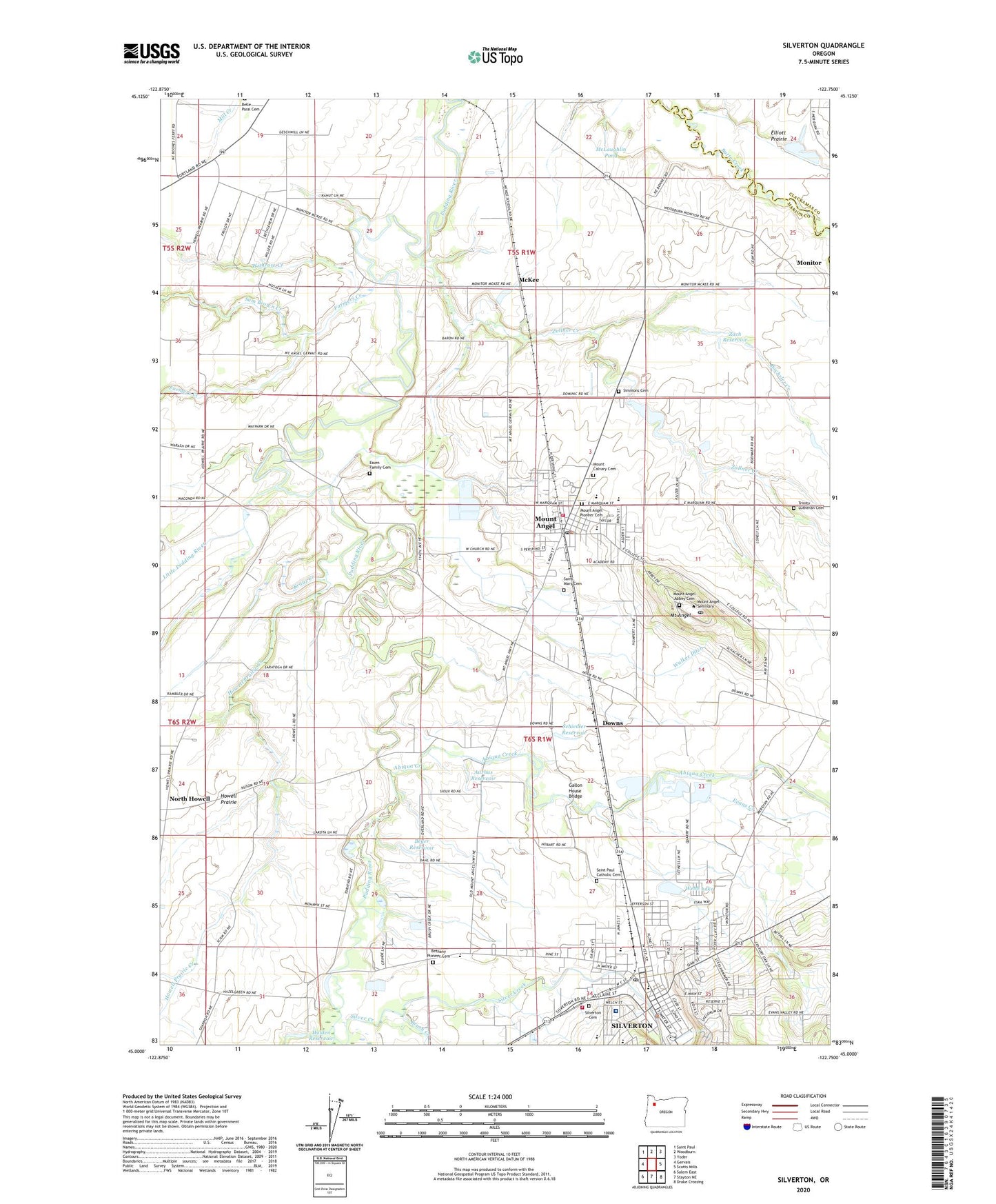
2023 topographic map quadrangle Silverton in the state of Oregon. Scale: 1:24000. Based on the newly updated USGS 7.5' US Topo map series, this map is in the following counties: Marion, Clackamas. The map contains contour data, water features, and other items you are used to seeing on USGS maps, but also has updated roads and other features. This is the next generation of topographic maps. Printed on high-quality waterproof paper with UV fade-resistant inks.
Quads adjacent to this one:
West: Gervais
Northwest: Saint Paul
North: Woodburn
Northeast: Yoder
East: Scotts Mills
Southeast: Drake Crossing
South: Stayton NE
Southwest: Salem East
This map covers the same area as the classic USGS quad with code o45122a7.
Contains the following named places: Aarhus Reservoir, Abiqua, Abiqua Creek, Baron, Belle Passi, Belle Passi School, Benedictine Sisters of Mount Angel Cemetery, Bernice, Bethany, Bethany Charter School, Bethany Pioneer Cemetery, Beyer Reservoir, Bochsler Creek, Brush Creek, City of Mount Angel, City of Silverton, Dominic, Downs, Drescher Ditch, Ebner County Park, Essen Family Cemetery, Eugene Field Elementary School, Evans Creek, Evergreen Golf Course, Farmers Creek, First Christian Church, Fisher Memorial Park, Gallon House Bridge, Holden Reservoir, Holy Family Academy, Howell Prairie Creek, J and J Farms, John B Humpert Park, John F Kennedy High School, Kraus Creek, Laurance Post Office, Little Pudding River, Lonely Lane Farms, Mark Twain Middle School, McKee, McKee Post Office, McKee School, McLaughlin Pond, Mount Angel, Mount Angel Abbey Cemetery, Mount Angel City Hall, Mount Angel Division, Mount Angel Fire District, Mount Angel Middle School, Mount Angel Municipal Court, Mount Angel Pioneer Cemetery, Mount Angel Police Department, Mount Angel Post Office, Mount Angel Public Library, Mount Angel Public Works Department Office, Mount Angel Seminary, Mount Angel Sewage Treatment Plant, Mount Calvary Cemetery, North Howell, North Howell Elementary School, Parkersville Post Office, Robert Frost Elementary School, Saint Benedict Post Office, Saint Benedicts Abbey, Saint Mary's Public School, Saint Paul Catholic Cemetery, Saint Pauls School, Sam Brown Creek, Schiedler Reservoir, Silver Creek, Silver Falls Library District, Silverfalls Timber Company Dam, Silverton, Silverton Airfield, Silverton Cemetery, Silverton Christian School, Silverton City Hall, Silverton Fire District Headquarters, Silverton High School, Silverton Hospital, Silverton Municipal Court, Silverton Police Department, Silverton Post Office, Silverton Public Works Department Office, Silverton Sewage Treatment Plant, Silverton Silver Trolley Dispatch, Silverton Water Treatment Plant, Simmons Cemetery, Tinclestead, Townsend, Trinity Lutheran Cemetery, Walker Ditch, Webb Lake, Withrow Creek, Woods Creek, Zach Reservoir, Zollner Creek, ZIP Codes: 97362, 97373