MyTopo
Bethel Pennsylvania US Topo Map
Couldn't load pickup availability
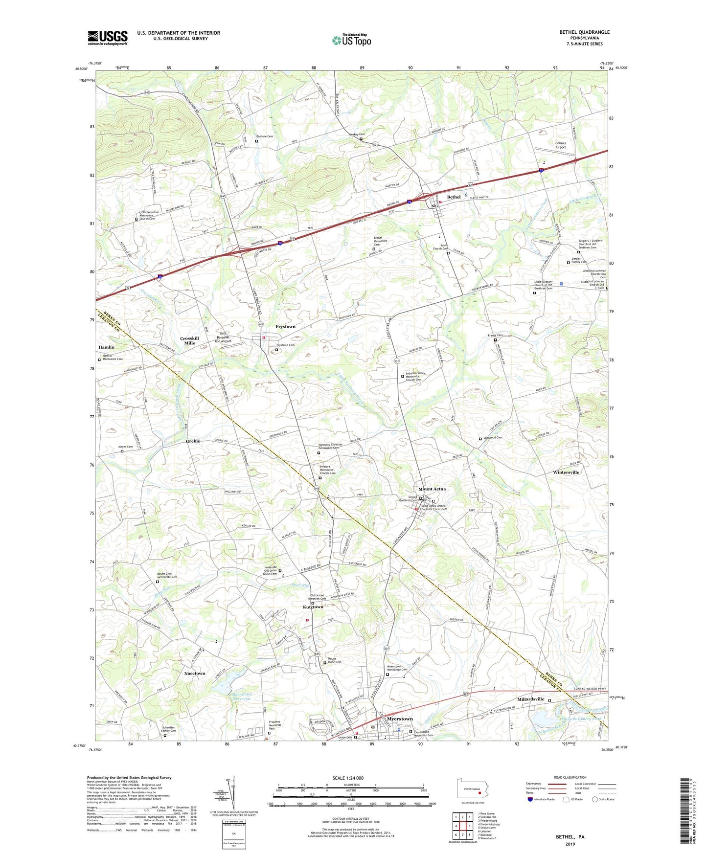
2023 topographic map quadrangle Bethel in the state of Pennsylvania. Scale: 1:24000. Based on the newly updated USGS 7.5' US Topo map series, this map is in the following counties: Berks, Lebanon. The map contains contour data, water features, and other items you are used to seeing on USGS maps, but also has updated roads and other features. This is the next generation of topographic maps. Printed on high-quality waterproof paper with UV fade-resistant inks.
Quads adjacent to this one:
West: Fredericksburg
Northwest: Pine Grove
North: Swatara Hill
Northeast: Friedensburg
East: Strausstown
Southeast: Womelsdorf
South: Richland
Southwest: Lebanon
This map covers the same area as the classic USGS quad with code o40076d3.
Contains the following named places: Altalaha Lutheran Church, Altalaha Lutheran Church Old Cemetery, American Legion Leon Deck Post 991, Assemblies of Yahweh International Headquarters, Bashore Cemetery, Bethel, Bethel Census Designated Place, Bethel Community Ambulance Service, Bethel Elementary School, Bethel Mennonite Cemetery, Bethel Post Office, Bethel Township Police Station, Bethel-Tulpehocken Public Library, Camp Greble, Camp Swatara, Crosskill Creek, Crosskill Mills, Frantz Cemetery, Friedens Memorial Park, Frystown, Frystown Cemetery, Frystown Census Designated Place, Frystown Fire Company Station 53, Frystown Lions Park, Golden Age Air Museum, Goodwill Fire Company Station 30, Greble, Grimes Airport, Hamlin Mennonite Cemetery, Harmony Christian Fellowship Cemetery, Hilltop Park Speedway, Jacksonville School, Krill Personal Use Airport, Kutztown, Kutztown Volunteer Community Fire Company Station 32, Lebanon Valley Golf Course, Lebanon Valley Mennonite Church Cemetery, Little Mountain Mennonite Church Cemetery, Little Swatara Church of the Brethren Cemetery, Livingood Cemetery, Merkey Cemetery, Merkey Church, Meyer Cemetery, Meyer Church, Mill Creek, Millards Quarry Pond, Millardsville, Mount Aetna, Mount Aetna Census Designated Place, Mount Aetna Post Office, Mount Hope Cemetery, Mount Zion Mennonite Cemetery, Myerstown Borough Police Department, Myerstown First Aid Unit Emergency Medical Service, Myerstown Mennonite Cemetery, Myerstown Post Office, Myerstown Reservoir, Myerstown School, Nacetown, Nicetown School, Northside Old Order Amish Cemetery, Old United Brethren Cemetery, Owl Creek, Rescue Fire Company 1 Mount Aetna Station 28, Saint Johns United Church of Christ, Saint Johns United Church of Christ Cemetery, Salem Church, Salem Lutheran Church, Salem Reformed Church Cemetery, Schaeffer Family Cemetery, Shikellamy Scout Camp, Sportsman Park, Stacks Dam, Steiners School, Stracks Dam, Sun Valley Mobile Home Park, Swatara Mennonite Church Cemetery, Township of Bethel, Township of Jackson, Township of Tulpehocken, Tri-County Worship Center, Tulpehocken Church, Tulpehocken Township Building, Tulpehocken Township Police Department, Tulpehocken Trinity United Church of Christ Cemetery, Union Canal, Union Cemetery, Union Fire Company of Bethel, Union Fire Company of Bethel Station 54, Union Meeting House, United Brethren Cemetery, Wintersville, Zeiglr Church, Ziegler Family Cemetery, Ziegler's Church of the Brethren Cemetery, Zion United Methodist Cemetery, ZIP Codes: 17067, 17087, 19544