MyTopo
Birdsboro Pennsylvania US Topo Map
Couldn't load pickup availability
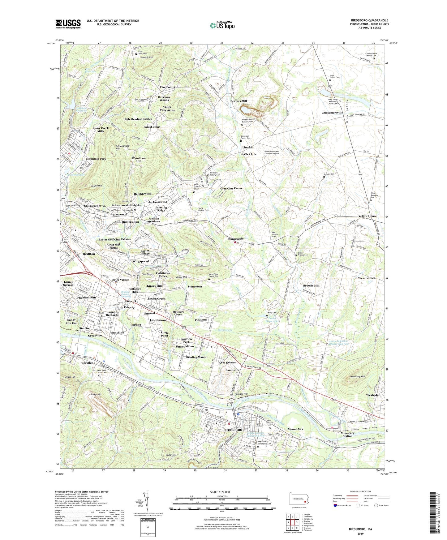
2023 topographic map quadrangle Birdsboro in the state of Pennsylvania. Scale: 1:24000. Based on the newly updated USGS 7.5' US Topo map series, this map is in the following counties: Berks. The map contains contour data, water features, and other items you are used to seeing on USGS maps, but also has updated roads and other features. This is the next generation of topographic maps. Printed on high-quality waterproof paper with UV fade-resistant inks.
Quads adjacent to this one:
West: Reading
Northwest: Temple
North: Fleetwood
Northeast: Manatawny
East: Boyertown
Southeast: Pottstown
South: Elverson
Southwest: Morgantown
This map covers the same area as the classic USGS quad with code o40075c7.
Contains the following named places: Amity Park Road Recreation Area, Amity Township Athletic Club, Amity Township Athletic Club Pool, Antietam Creek, Antietam Middle-Senior High School, Antietam Reservoir, Antietam School, Antietam Valley Recreation and Community Center, Arrowhead Golf Course, AVM Estates, Baumstown, Baumstown Census Designated Place, Beards School, Beavers Mill, Beidlertown, Ben Franklin Inn, Berks Christian School, Bertolet Bakehouse, Bertolet Cemetery, Bertolet House, Bertolet Sawmill, Bert's Airport, Beverly Manor, Biebers Mill, Birdsboro, Birdsboro - Union Fire Department Station 7 - 1, Birdsboro Borough Hall, Birdsboro Community Memorial Center, Birdsboro Elementary Center, Birdsboro Estates, Birdsboro Masonic Temple, Birdsboro Memorial VFW Post 411, Birdsboro Post Office, Birdsboro Wastewater Treatment Plant, Boonecroft, Bordic Trailer Park, Borough of Birdsboro, Borough of Saint Lawrence, Breneiser Woods, Brice Village, Brooke Mansion, Brooklyn, Browns Mill, Carsonia Lake, Carsonia Park, Cedar Hill, Central Catholic Field, Chestnut Court Apartments, Church Hill, Collins Mill, Country Club Run, Country Club Run II, Daniel Boone High School, Daniel Boone Homestead, Daniel Boone Lake, Daniel Boone Optimist Field, DeBenneyville House, DeTurk Cemetery, Devon Green, Dyer Quarry, Eastwick, Esterly Post Office, Exeter Emergency Medical Services, Exeter Friends Cemetery, Exeter Friends Meeting House, Exeter Golf Club Estates, Exeter Medical Center, Exeter Plaza, Exeter Public Golf Course, Exeter School, Exeter Square, Exeter Township Community Park, Exeter Township Junior High School, Exeter Township Precinct 1, Exeter Township Precinct 2, Exeter Township Precinct 3, Exeter Township Precinct 5, Exeter Township Precinct 6, Exeter Township Precinct 7, Exeter Township Precinct 8, Exeter Township School District Administration Building, Exeter Township Senior High School, Exeter Township Wastewater Treatment Plant, Exeter Village, Fairview Church, Fairview Park, Fairway, Farming Ridge, Farming Ridge Park, Fire Lake, Five Points, Flannery Mill, Forest Court, Friendship Country Home, Furnace Hill, Gibraltar, Gibraltar Census Designated Place, Gibraltar Fire Company 1 Station 23, Gibraltar Park, Glen Oley Farms, Golfshire Hills, Gollub Dam, Green Tree Acres, Greenview, Greisemersville, Griesemersville, Grist Mill Farms, Guldin Hill, Guldin Memorial Site, Hay Creek, Hechler - Esterly Family Cemetery, Heisters Creek, Herbein Family Burial Ground, High Meadow Estates, Hill Road Park, Hill School, Hoch - DeTurck - Schenkel Cemetery, Hohls Crossing, Hunters Run, Immaculate Conception Academy, Immaculate Conception Cemetery, Indian Corn Creek, Jackson Meadows, Jacksonwald, Jacksonwald Census Designated Place, Jacksonwald Elementary School, Jean Bertolet Memorial Monument, Kauffman Farm Cemetery, Kinsey Hill, Klein - Close Family Cemetery, Knabb Homestead Family Graveyard, Lake Antietam Dam, Laurel Springs, Limekiln, Limekiln Creek, Limekiln Post Office, Lincoln Corporate Center, Lincoln Homestead, Lincolntown, Lincolnwood, Linstead, Long Pond, Lorane, Lorane Census Designated Place, Lorane Elementary School, Lorane Hollow Park, Lorane Orchards, Mainbird Park, Maple Springs Swimming Pool, Martin Luther Lausch Elementary School, Marywood, Mexico, Mill Dam, Molasses Creek, Monocacy, Monocacy Creek, Monocacy Elementary Center, Monocacy Hill, Monocacy Hill Recreation Area, Monocacy Kindergarten Center, Monocacy Station, Mount Airy, Mountain Park, Mountain Park Playground, Oley Line, Oley Valley Mennonite Church Cemetery, Overlook Woods, Owatin Creek, Pathfinder Valley, Penn View Mobile Home Park, Pet Animal Cemetery, Pheasant Run, Pine Ridge, Pineland, Pineland Park, Pioneer Crossing Landfill, Ramblewood, Reading Country Club, Reading Country Club Spring, Reading Mall, Reading Manor, Reading Station Post Office, Reiffton, Reiffton Census Designated Place, Reiffton School, Ritter Number 2 Cemetery, Robeson Crossing, Saint Johns Church Cemetery - West, Saint Lawrence, Saint Lawrence Playground, Saint Michaels Cemetery, Sandy Run East, Schneider Family Cemetery, Schuylkill Canal, Schuylkill River Open Space, Schwarzwald Cemetery, Schwarzwald Heights, Schwarzwald Hill, Seidel Creek, Seidel Hill, Seideltown School, Sheep Hill, Shelbourne Square, Silvertown, Sixpenny Creek, South Birdsboro, Spies Church, Spies Zion Cemetery, Spirit Creek, Stonersville, Stonetown, Stony Creek Mills, Stony Creek Mills Census Designated Place, Sunrise, Sunset Manor, Sunshine, Texas, Texas Ball Diamond, Township of Exeter, Township of Oley, Union Township Recreation Area, Valley Ridge Farms, Valley View Acres, Valley View Mobile Homes, Weavertown, Westridge, Wingspread, Wyndham Hill, Yellow House, Young - Kissling Cemetery, ZIP Codes: 19508, 19518, 19535, 19542, 19606