MyTopo
California Pennsylvania US Topo Map
Couldn't load pickup availability
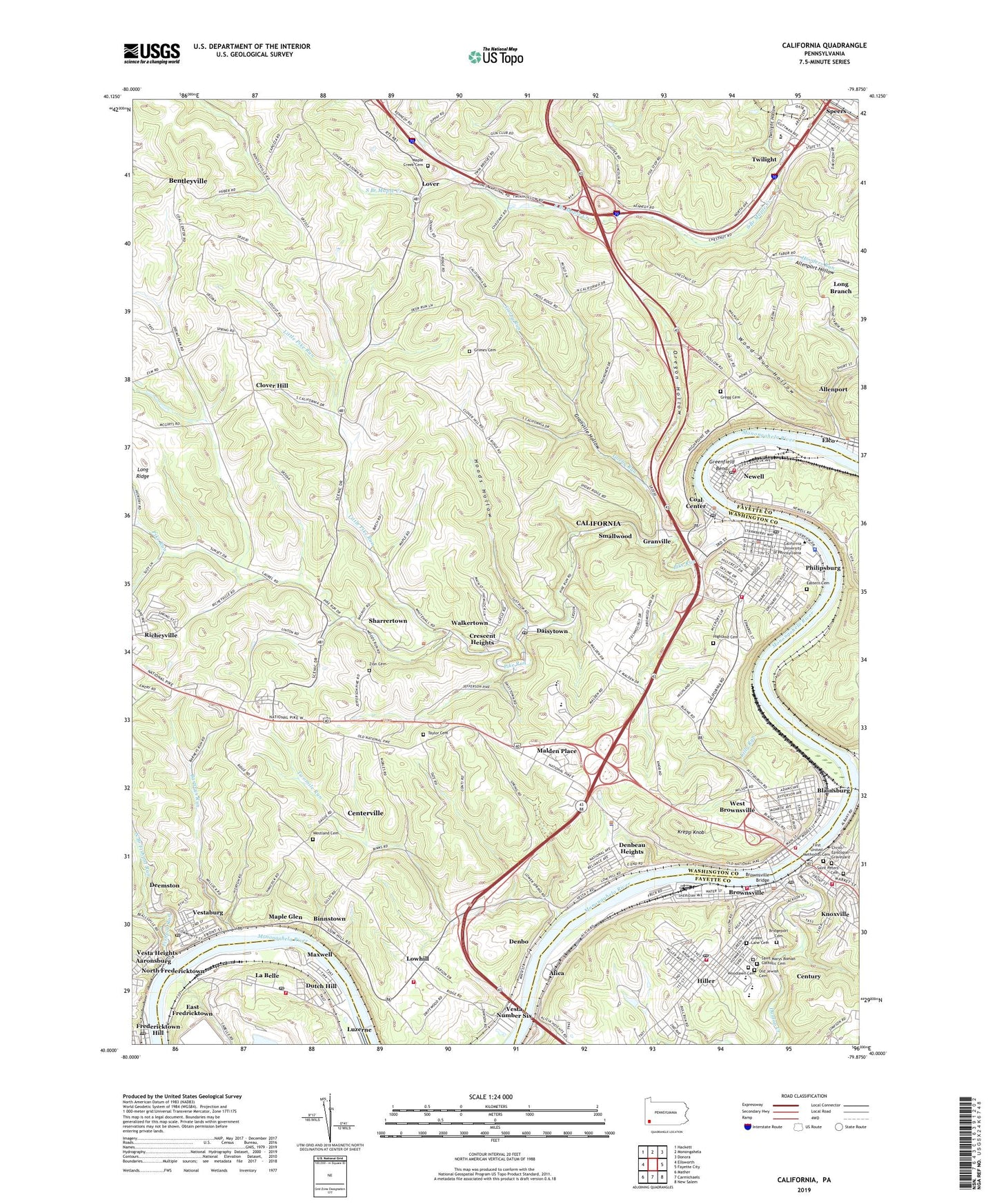
2023 topographic map quadrangle California in the state of Pennsylvania. Scale: 1:24000. Based on the newly updated USGS 7.5' US Topo map series, this map is in the following counties: Washington, Fayette. The map contains contour data, water features, and other items you are used to seeing on USGS maps, but also has updated roads and other features. This is the next generation of topographic maps. Printed on high-quality waterproof paper with UV fade-resistant inks.
Quads adjacent to this one:
West: Ellsworth
Northwest: Hackett
North: Monongahela
Northeast: Donora
East: Fayette City
Southeast: New Salem
South: Carmichaels
Southwest: Mather
This map covers the same area as the classic USGS quad with code o40079a8.
Contains the following named places: Alica, Azorsky Hall, Barneys Run, Binnstown, Blainsburg, Borough of Brownsville, Borough of California, Borough of Centerville, Borough of Coal Center, Borough of Elco, Borough of Long Branch, Borough of Newell, Borough of Speers, Borough of Twilight, Borough of West Brownsville, Bridgeport Cemetery, Brownsville, Brownsville Ambulance Service, Brownsville Bridge, Brownsville Fire Company 1 Station 5, Brownsville Police Department, Brownsville Post Office, California, California High School, California Overlook, California Post Office, California Public Library, California University of Pennsylvania, California University Police, California University Teacher Enhancement Center, California Volunteer Fire Department Station 23, Centerville, Century, Christ Episcopal Graveyard, Clover Hill, Clyde Hall, Coal Center, Coal Center Post Office, Coover Annex, Crescent Heights, Daisytown, Daisytown Post Office, Denbeau Heights, Denbo, Denbo Vesta Six Volunteer Fire Company Station 19, Dixon Hall, Downey-Garofalo Health Center, Duda Hall, Dunlap Creek, Dutch Hill, East End School, East Fredricktown, Ebenezer Church, Eberly Hall, First United Methodist Cemetery, Fishpot Run, Fredericktown, Fredericktown Post Office, Gorby Run, Granville, Granville Hollow, Green Lane Cemetery, Greenfield Bend, Gregg Cemetery, Grimes Cemetery, Hamer Hall, Herron Hall, Highland Cemetery - West, Hiller, Hiller Census Designated Place, Hiller Elementary School, Hiller Post Office, Hiller Volunteer Fire Department Station 21, Hoods Hollow, Howe Church, Howe School, Intermediate Unit 1 School, Kara Alumni House, Keystone Hall, Knoxville, Krepp Knob, La Belle, La Belle Post Office, Lilly Run, Little Pike Run, Longanecker Hall, Lover, Lover Church, Lowhill, Lucyville, Luzerne Township Volunteer Fire Company Station 23, Malden Place, Manderino Library, Maple Creek Cemetery, Maple Glen, Marchandville, Maxwell, Maxwell Pool, Moffitts Mills, Natali Student Center, New Science Hall, Newell, Newell Post Office, Newell Volunteer Fire Company Station 30, North Branch Fishpot Run, Noss Annex, Noss Hall, Oak Grove Church, Old Jewish Cemetery, Oregon Hollow, Pace School, Peoples School, Philipsburg, Phillipsburg Cemetery, Pike Mine, Pike Run, Pollock Building, Redstone Creek, Republican School, Rush Run, Saint James Church, Saint Marys Church, Saint Marys Roman Catholic Cemetery, Saint Nicholas Cemetery, Saint Pauls Church, Saint Peters Cemetery, Sharrertown, Simpson Ferry, Smallwood, South Brownsville Volunteer Fire Company 1 Station 6, Speers, Steele Hall, Taylor Cemetery, Taylor Church, Toddlers Patch Child Care Center, Township of West Pike Run, Twilight, Twilight Hollow, Twin Lakes, Twomile Run, Vesta Heights, Vesta Number Six, Vestaburg, Vestaburg Post Office, Vulcan Hall, Walkertown, Walkertown School, WASP-AM (Brownsville), WESA-AM (Charleroi), WESA-FM (Charleroi), West Brownsville, West Brownsville Volunteer Fire Company, West Pike Run Grange, Westland Cemetery, Wood Run, Wood Run Hollow, Woodlawn Cemetery, WVCS-FM (California), Zion Cemetery, Zion Hill Church, ZIP Codes: 15022, 15368, 15417, 15419, 15423, 15427, 15429, 15434, 15444, 15450, 15466