MyTopo
Cedar Run Pennsylvania US Topo Map
Couldn't load pickup availability
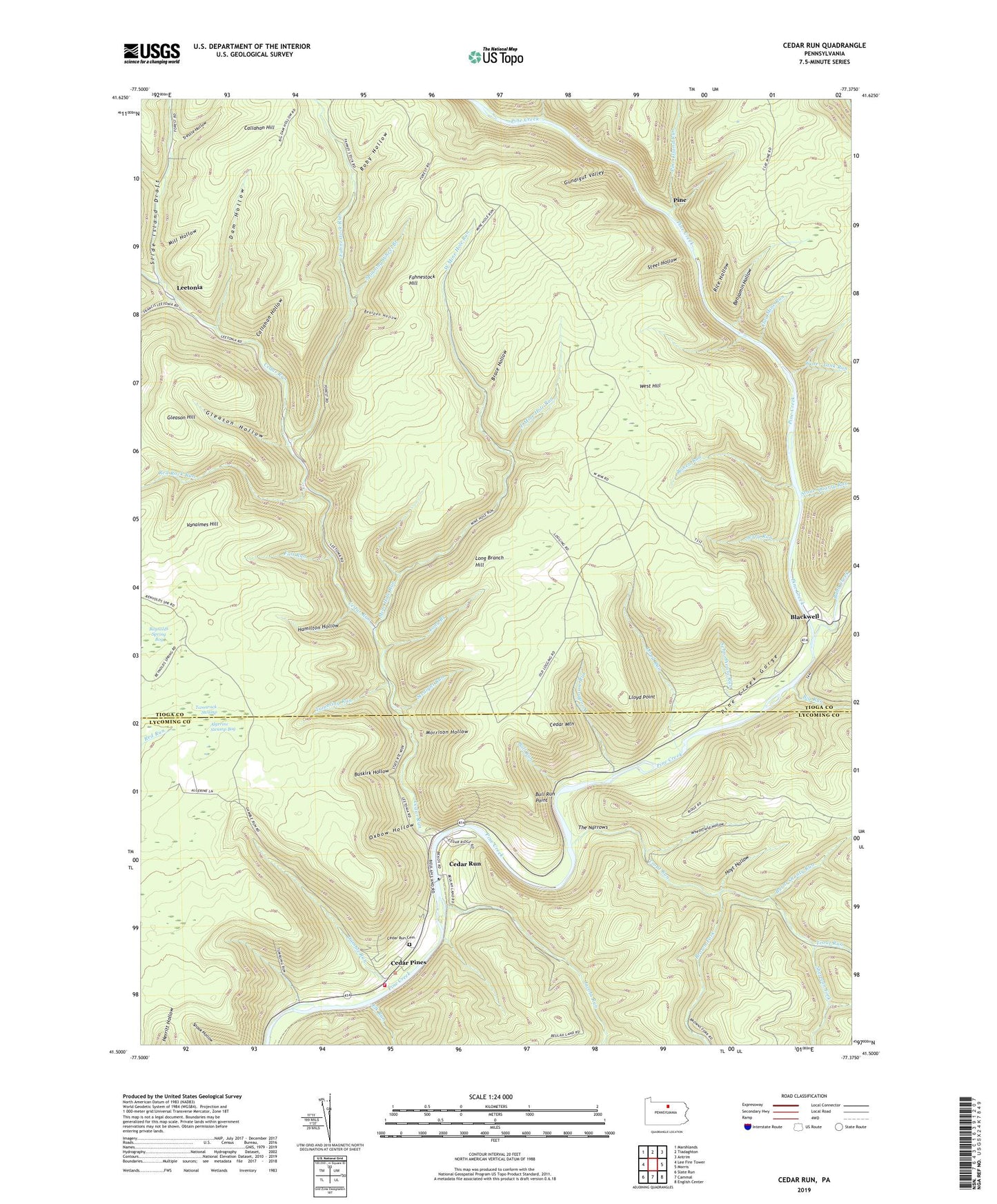
2023 topographic map quadrangle Cedar Run in the state of Pennsylvania. Scale: 1:24000. Based on the newly updated USGS 7.5' US Topo map series, this map is in the following counties: Tioga, Lycoming. The map contains contour data, water features, and other items you are used to seeing on USGS maps, but also has updated roads and other features. This is the next generation of topographic maps. Printed on high-quality waterproof paper with UV fade-resistant inks.
Quads adjacent to this one:
West: Lee Fire Tower
Northwest: Marshlands
North: Tiadaghton
Northeast: Antrim
East: Morris
Southeast: English Center
South: Cammal
Southwest: Slate Run
This map covers the same area as the classic USGS quad with code o41077e4.
Contains the following named places: Algerine Swamp Bog, Algerine Swamp Natural Area, Algerine Trail, Ashworth Trail, Babb Creek, Bearpen Hollow, Benjamin Hollow, Big Dam Hollow Trail, Big Run, Black Forest Trail, Blackwell, Bohen Run, Bohen Trail, Brace Hollow, Brown Fork, Brown Township Volunteer Fire Company Station 35, Bull Run, Bull Run Point, Burnt Shanty Run, Bushkirk Trail, Buskirk Hollow, Callahan Hill, Callahan Hollow, Cedar Mountain, Cedar Pines, Cedar Run, Cedar Run Cemetery, Cedar Run Church, Charman Trail, Clay Mine Run, Dam Hollow, Dillon Trail, East Branch Trail, East Mine Hole Run, Elk Run, Fahnestock Hill, Fahnestock Run, Fall Run, Frying Pan Run, Gamble Run, Gleason Hill, Gleason Hollow, Gundigut Valley, Hamilton Hollow, Hoyt Hollow, Huck Trail, Huckleberry Trail, Jacobs Run, Jerry Run, Leetonia, Lloyd Point, Lloyd Post Office, Lloyd Run, Lloyd Trail, Long Branch, Long Branch Hill, Mill Hollow, Mine Hole Run, Morrison Hollow, Old Mountain Trail, Oxbow Hollow, Pine, Pine Creek Gorge Natural Area, Pine Island Run, Pine Trail, Plantatation Trail, Putt Hollow Trail, Rail Island Run, Red Rock Run, Red Rock Trail, Reynolds Spring Bog, Rice Hollow, Roby Hollow, Schoolhouse Run, Sherman Fork, Slide Island Draft, Spinning Wheel Branch, Spinningwheel Trail, Steel Hollow, Steel Hollow Trail, Stone Quarry Run, Straight Run, Tamarack Swamp, The Narrows, Trestle Hollow, Trout Run, Tumbling Run, Tumbling Run Trail, Vanaimes Hill, Water Tank Run, West Hill, West Mine Hole Run, Wheatfield Hollow, Woodhouse Run, ZIP Code: 17727