MyTopo
Clarion Pennsylvania US Topo Map
Couldn't load pickup availability
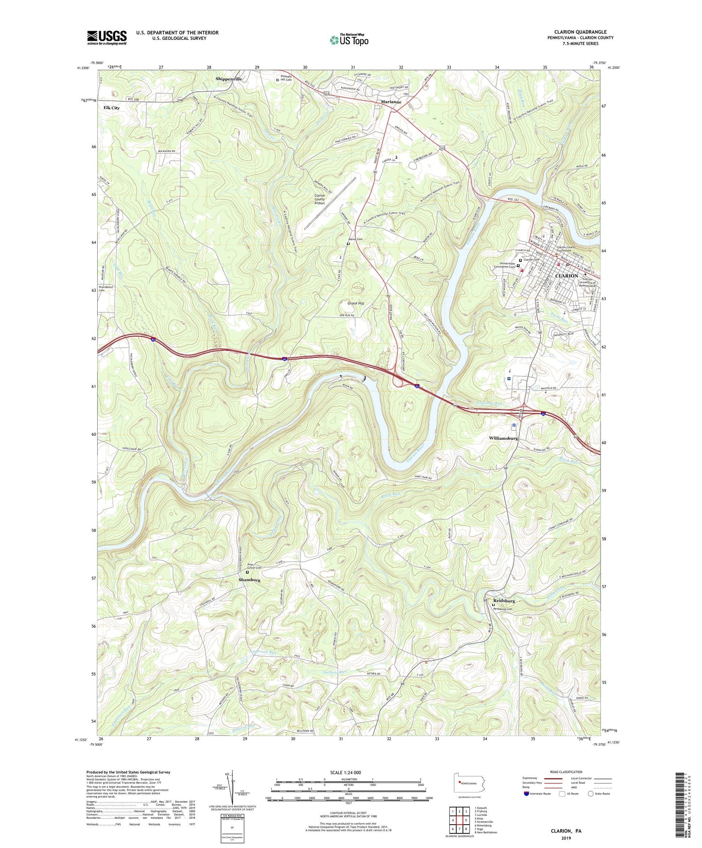
2023 topographic map quadrangle Clarion in the state of Pennsylvania. Scale: 1:24000. Based on the newly updated USGS 7.5' US Topo map series, this map is in the following counties: Clarion. The map contains contour data, water features, and other items you are used to seeing on USGS maps, but also has updated roads and other features. This is the next generation of topographic maps. Printed on high-quality waterproof paper with UV fade-resistant inks.
Quads adjacent to this one:
West: Knox
Northwest: Kossuth
North: Fryburg
Northeast: Lucinda
East: Strattanville
Southeast: New Bethlehem
South: Sligo
Southwest: Rimersburg
This map covers the same area as the classic USGS quad with code o41079b4.
Contains the following named places: Alumni and Development Center Building, Alumni House - Clarion University of Pennsylvania, Anabel Lee Ralston Hall, Bertha Nair Hall, Borough of Clarion, Boyd Run, Brush Run, Bryners Station, Buckhorn School, Carrier Administration Building, Ceramics Laboratory Building, Chandler Dining Hall, Clarion, Clarion Cemetery, Clarion County, Clarion County Airport, Clarion County Sheriff's Office, Clarion Fire and Hose Company Station 520, Clarion Hospital, Clarion Hospital Emergency Medical Services, Clarion Junction, Clarion Post Office, Clarion Psychiatric Center, Clarion University of Pennsylvania, Coal Run, Concord Church, Courtleys Run, Deer Creek, Department of Conservation and Natural Resources Kittanning Forest District 8, Egbert Hall, Frank M Campbell Hall, Gathers Run, Gemmell Park, Gemmell Student Center, Gretchen Station, Groce Hill, Hart Chapel Theatre, Haskett House, Immaculate Conception Cemetery, J George Becht Hall, J W F Wilkinson Hall, John Ballentine Hall, Keeling Health Center, Knox Spur Station, Larimer School, Lorena M Givan Hall, Madison School, Manor Cemetery, Manor Church, Marianne, Marianne Census Designated Place, Marwick - Boyd Fine Arts Center, Mayfield Golf Course, Paint Creek, Peirce Science Center, Pennsylvania State Police Troop C Clarion Station, Pine Grove Cemetery, Pine Grove Church, Piney Creek, Piney Dam, Piney Reservoir, Pleasant Hill Cemetery, Rapp Run, Reids Run, Reidsburg, Reidsburg Cemetery, Shamburg, Special Projects Center, State Game Lands Number 63, State Game Lands Number 72, Still Hall Business Administration and Computer Center, Tippin Gymnasium, Tippin Natatorium, Toby Creek, Township of Monroe, Township of Paint, Township of Piney, Trout Run, University Gallery, WCUC-FM (Clarion), Williamsburg, Wilson Mill, ZIP Code: 16255