MyTopo
Danville Pennsylvania US Topo Map
Couldn't load pickup availability
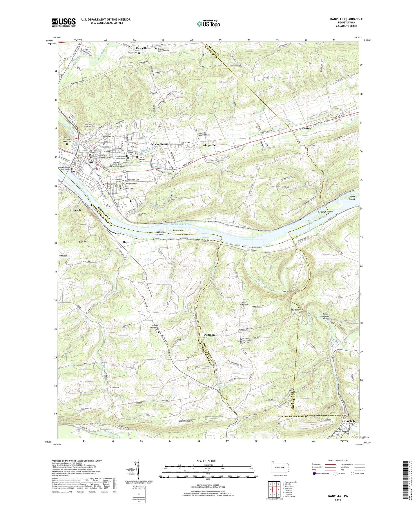
2023 topographic map quadrangle Danville in the state of Pennsylvania. Scale: 1:24000. Based on the newly updated USGS 7.5' US Topo map series, this map is in the following counties: Montour, Northumberland, Columbia. The map contains contour data, water features, and other items you are used to seeing on USGS maps, but also has updated roads and other features. This is the next generation of topographic maps. Printed on high-quality waterproof paper with UV fade-resistant inks.
Quads adjacent to this one:
West: Riverside
Northwest: Washingtonville
North: Millville
Northeast: Bloomsburg
East: Catawissa
Southeast: Mount Carmel
South: Shamokin
Southwest: Trevorton
This map covers the same area as the classic USGS quad with code o40076h5.
Contains the following named places: Blizzards Run, Blue Hill, B'nai Zion New Cemetery, B'nai Zion Old Cemetery, Borough of Danville, Boyd, Bropps, Cherokee Golf Course, Clarks Island, Continental Fire Company Station 30, Danville, Danville Alliance Church, Danville Ambulance Service Station 120, Danville Area Senior High School, Danville Elementary School, Danville Mennonite Cemetery, Danville Mennonite Church, Danville Middle School, Danville Police Department, Danville Post Office, Danville State Hospital, Deal High School, East End Fire Company Station 60, Episcopal Cemetery, Fairview Cemetery, Friendship Fire Company Station 10, Frosty Valley Country Club, Geisinger HealthSouth Rehabilitation Hospital, Geisinger Medical Center, German Lutheran Cemetery, Good Will Hose Company Station 40, Grovania, Grove Presbyterian Church Memorial Garden, Holy Family Convent, Hopewell Park, Kase Run, Kaseville, Knoebels Grove, Lawrence L Knoebel Covered Bridge, Lazarus Cemetery, Little Roaring Creek, Logan Run, Mahoning Cooper Elementary School, Mahoning Township Police Department, Mechanicsville, Mechanicsville Census Designated Place, Menches Island, Montour County Sheriff's Office, Mugser Run, Odd Fellows Cemetery, Old Presbyterian Church Cemetery, Old Saint Josephs Cemetery, Quitman, Reeder Covered Bridge, Reeds Island, Reformed Cemetery Shiloh, Ridgeville, Ridgeville Reformed Cemetery, Riegel Covered Bridge, Roaring Creek, Rohrbach Covered Bridge, Rush Church, Saint Cyrils Academy, Saint Huberts Cemetery, Saint Johns Church, Saint Johns Evangelical Lutheran Church Cemetery, Saint Joseph Cemetery, Saint Josephs School, Saint Peters Church, Sechler Run, Shamokin Hill, Sharp Ridge, Sharp Ridge Cemetery, Sharp Ridge Church, Sisters of Saints Cyril and Methodius Cemetery, South Branch Roaring Creek, South Danville Station, Stone Castle Motel Airport, Straub Church, Straubs Lutheran Cemetery, The Pinnacle, Toby Run, Township of Cooper, Township of Mahoning, Township of Mayberry, Township of Montour, Union Corner, Vastines Island, Villa of the Sacred Heart Cemetery, Washies Playground, Washington Fire and Hose Company Station 20, Welsh Congregational Church, Wilson Cemetery, WPGM-FM (Danville), ZIP Code: 17822