MyTopo
Ellsworth Pennsylvania US Topo Map
Couldn't load pickup availability
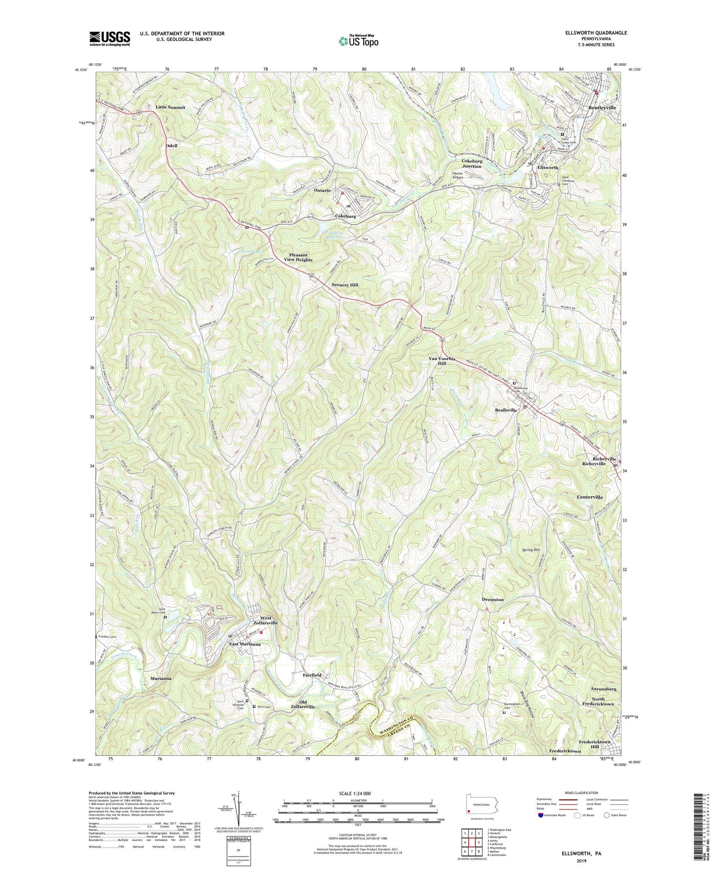
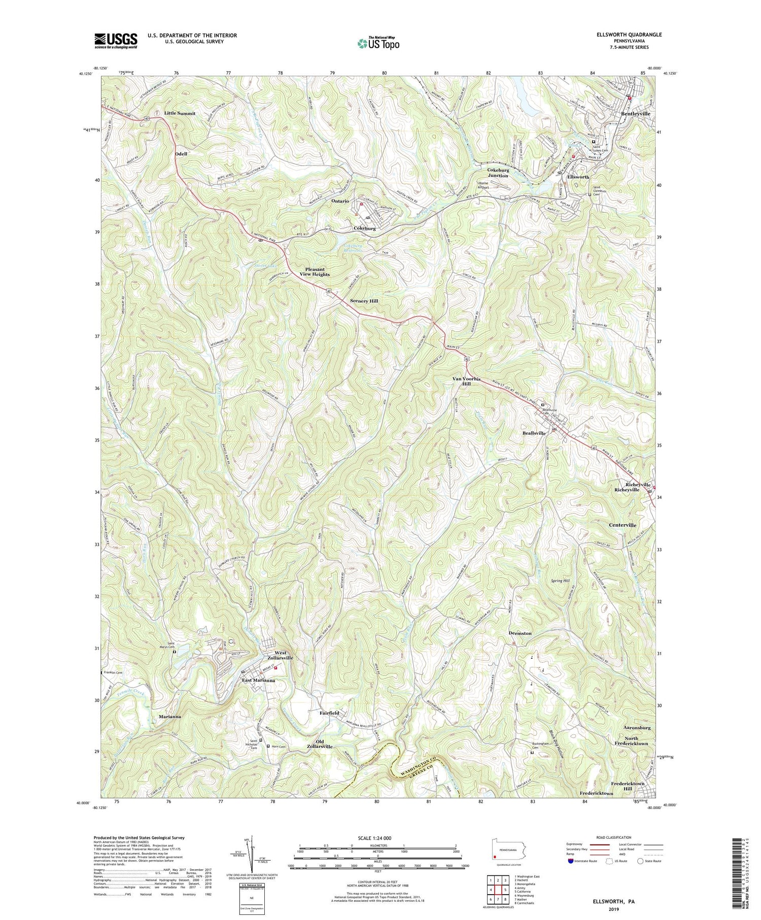
2019 topographic map quadrangle Ellsworth in the state of Pennsylvania. Scale: 1:24000. Based on the newly updated USGS 7.5' US Topo map series, this map is in the following counties: Washington, Greene. The map contains contour data, water features, and other items you are used to seeing on USGS maps, but also has updated roads and other features. This is the next generation of topographic maps. Printed on high-quality waterproof paper with UV fade-resistant inks.
Quads adjacent to this one:
West: Amity
Northwest: Washington East
North: Hackett
Northeast: Monongahela
East: California
Southeast: Carmichaels
South: Mather
Southwest: Waynesburg
Contains the following named places: Aaronsburg Census Designated Place, Active Sludge Pond, Barrs Run, Barrs School, Beallsville, Beallsville Boro Police Department, Beallsville Cemetery, Beallsville Post Office, Bentleyville, Bentleyville Police Department, Bentleyville Post Office, Bentleyville Public Library, Bentleyville Volunteer Fire Department, Bentworth Senior High School, Borough of Beallsville, Borough of Bentleyville, Borough of Cokeburg, Borough of Deemston, Borough of Ellsworth, Borough of Marianna, Buckingham Cemetery, Center Branch Pigeon Creek, Century Inn, Chippewa Golf Course, Cokeburg, Cokeburg Junction, Cokeburg Post Office, Cokeburg Reservoir, Cokeburg Volunteer Fire Company Station 63, Cokeburg Water Supply Dam, Daniels Run, Deemston, Deemston School, East Bethlehem Church, East Marianna, Ellsworth, Ellsworth Borough Building, Ellsworth Number Two Dam, Ellsworth Post Office, Ellsworth Reservoir, Ellsworth Volunteer Fire Company Station 38, Fairfield, Fredericktown Census Designated Place, Fredericktown Hill, Ghent Substation, Highland Church, Hillsboro, Home Base Airport, Horn Cemetery - East, Horn Run, Horne Airport, Little Daniels Run, Little Summit, Marianna, Marianna Community Public Library, Marianna Post Office, Marianna Volunteer Fire Company Station 67, Mine 51 Pond Three Dam, Mount Calvary Church, Nemacolin Golf Course, Nicholls School, North Fredericktown, Odell, Old Zollarsville, Ontario, Passavant Hospital, Patterson Run, Pleasant View Heights, Plum Run, Pond E, Pond F, Radio Park, Richeyville, Richeyville Post Office, Richeyville Volunteer Fire Company Station 27, Saint Clements Cemetery, Saint Lukes Cemetery, Saint Nicholas Cemetery, Saints Mary and Ann Cemetery, Scenery Hill, Scenery Hill Post Office, Somerset Number Sixty Dam, Somerset Number Sixty Pond E Dam, South Branch Pigeon Creek, Spring Hill, State Game Lands Number 297, Steves Lake, Tenmile Church, Township of North Bethlehem, Township of West Bethlehem, Turkeyfoot, Ulery School, Van Voorhis Hill, West Bethlehem High School, West Zollarsville, Zion Church, ZIP Codes: 15313, 15324, 15331, 15333, 15345, 15358, 15360