
MyTopo
Fredericksburg Pennsylvania US Topo Map
Couldn't load pickup availability
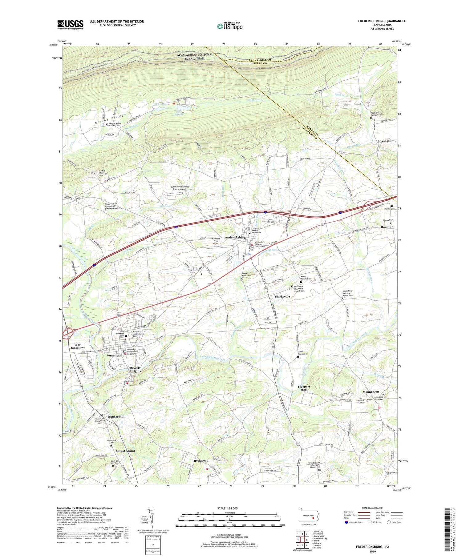
2019 topographic map quadrangle Fredericksburg in the state of Pennsylvania. Scale: 1:24000. Based on the newly updated USGS 7.5' US Topo map series, this map is in the following counties: Lebanon, Berks, Schuylkill. The map contains contour data, water features, and other items you are used to seeing on USGS maps, but also has updated roads and other features. This is the next generation of topographic maps. Printed on high-quality waterproof paper with UV fade-resistant inks.
Quads adjacent to this one:
West: Indiantown Gap
Northwest: Tower City
North: Pine Grove
Northeast: Swatara Hill
East: Bethel
Southeast: Richland
South: Lebanon
Southwest: Palmyra
Contains the following named places: Beach Run, Bethel Church, Bethel Moravian Cemetery, Bethel Township Police Department, Beverly Heights, Black Oak Hill Cemetery, Blue Mountain Christian School, Blue Mountain View Golf Course, Borough of Jonestown, Bunker Hill, Bunker Hill Evangelical Cemetery, Bunker Hill Fire Station, Bunker Hills, Camp Arewa, Camp Carson, Camp Strause, Camp Strause Fire Company Station 45, Cedar Hill Cemetery, Deep Run, Dutch Country Egg Farms Airport, Earlakill Run, Elizabeth Run, Evangelical Meeting House Cemetery, Fairview School, Farmers Pride Airport, Fredericksburg, Fredericksburg Census Designated Place, Fredericksburg Elementary School, Fredericksburg Fire Company Station 41, Fredericksburg Post Office, Freeport Mills, Freeport Mills Golf Course, Glenn Lebanon Fire Company Station 42, Gosherts Church, Groff School, Grove Farm Cemetery, Hamlin, Hamlin Cemetery, Horst Airport, Jonestown, Jonestown Elementary School, Jonestown Fire Company Station 10, Jonestown Post Office, Jonestown Reformed and Old Cemetery, Klopps Cemetery, Lake Dalrymple Dam, Lake Strause, Lake Strauss Dam, Lake Weiss, Light's Graveyard, Little Mountain, Little Swatara Creek, Meck Creek, Meckville, Meckville Church, Meckville Mennonite Cemetery, Meyer Family Cemetery, Monroe Valley Chapel Cemetery, Monroe Valley Golf Course, Monroe Valley School, Mount Ararat, Mount Zion, Mount Zion Community Fire Company Station 40, Mountville Cemetery, Mountville School, North Lebanon Mennonite Church Cemetery, Northern Lebanon High School, Oil Creek, Old Indian Trail, Our Lady of Fatima Chapel, Pennsylvania State Police - Jonestown, Red Run, Rockwood, Saint Elizabeth Church, Saint John's Lutheran Church Cemetery, Sherks School, Shirksville, Shirksville Church, Shirksville Mennonite Church Cemetery, Swope School, Township of Bethel, Township of Swatara, Umberger School, Union - Salem Evangelical Congregational Cemetery, Union Church, Union Salem Church, Wenger Meetinghouse, Wenger Meetinghouse Cemetery, Wenger School, West Jonestown, Wolfe School, Wolfs Union Meeting House Cemetery, Zion Gosherts Union Church Cemetery, Zion Lutheran Cemetery, Zoar Lutheran Cemetery, ZIP Codes: 17026, 17046


