MyTopo
Landisburg Pennsylvania US Topo Map
Couldn't load pickup availability
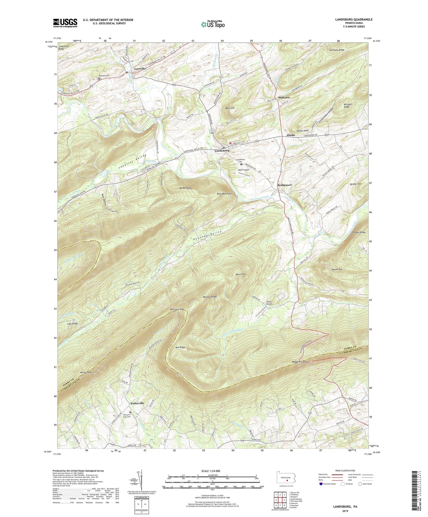
2023 topographic map quadrangle Landisburg in the state of Pennsylvania. Scale: 1:24000. Based on the newly updated USGS 7.5' US Topo map series, this map is in the following counties: Perry, Cumberland. The map contains contour data, water features, and other items you are used to seeing on USGS maps, but also has updated roads and other features. This is the next generation of topographic maps. Printed on high-quality waterproof paper with UV fade-resistant inks.
Quads adjacent to this one:
West: Andersonburg
Northwest: Spruce Hill
North: Ickesburg
Northeast: Newport
East: Shermans Dale
Southeast: Carlisle
South: Plainfield
Southwest: Newville
This map covers the same area as the classic USGS quad with code o40077c3.
Contains the following named places: Alinda, Baken Creek, Barkley Ridge, Bells Hill, Berrys Gap, Bixler Run, Borough of Landisburg, Bridgeport, Egolf Airport, Entlerville, Frankford Airport, Germany Ridge, Green Valley Run, Hidden Valley Boy Scout Camp, Hidden Valley Boy Scouts East Camp, Kennedy Valley, Kennedy Valley Church, Kennedy Valley School, Landisburg, Landisburg Ambulance Association Station 49, Landisburg Cemetery, Landisburg Post Office, Landisburg Volunteer Fire Company Station 4, Laurel Run, Laurel Run Church, Little Indian Hollow, Loysville, Loysville Post Office, McCabe Run, McClures Gap, McClures Gap Cemetery, McClures Gap Church, McClures Gap School, Metz Airport, Middle Ridge, Milltown, Montour Creek, Mount Dempsey, Mount Zion Church, Muddy Run, Oak Grove Church, Oak Grove School, Oakgrove, Pine Hill School, Quaker Hill, Restland Cemetery, Round Top, Sheaffer Valley, Shulls Airport, Spotts Knob, Spring Dale School, Spruce Bank School, Stambaugh Farm Run, Stilhouse Hollow, Township of Spring, Township of Tyrone, Tressler Orphan Home, Trout Run, Waggoners Gap, Welch Hill, Wolf Hollow, ZIP Code: 17040