MyTopo
New Salem Pennsylvania US Topo Map
Couldn't load pickup availability
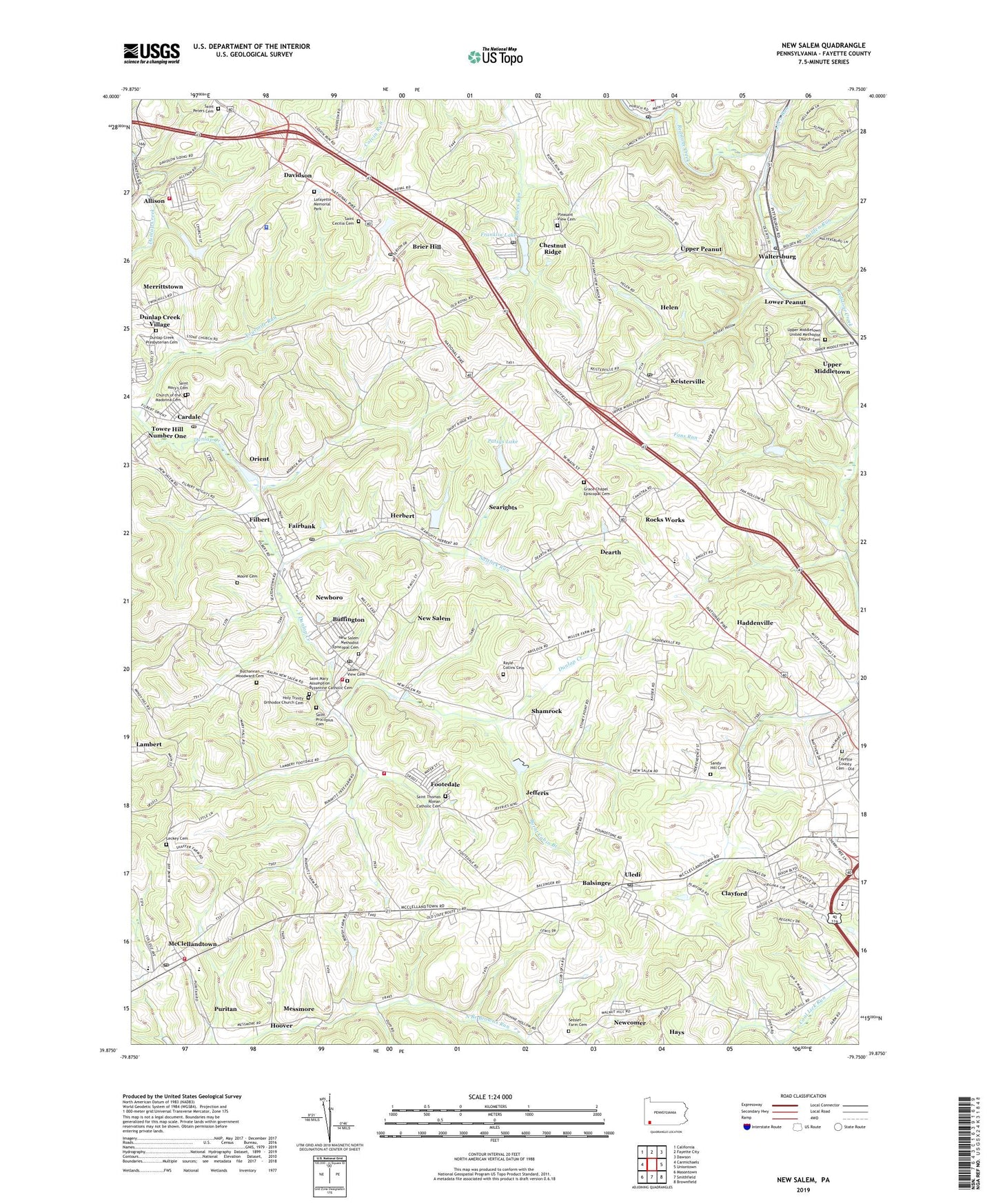
2019 topographic map quadrangle New Salem in the state of Pennsylvania. Scale: 1:24000. Based on the newly updated USGS 7.5' US Topo map series, this map is in the following counties: Fayette. The map contains contour data, water features, and other items you are used to seeing on USGS maps, but also has updated roads and other features. This is the next generation of topographic maps. Printed on high-quality waterproof paper with UV fade-resistant inks.
Quads adjacent to this one:
West: Carmichaels
Northwest: California
North: Fayette City
Northeast: Dawson
East: Uniontown
Southeast: Brownfield
South: Smithfield
Southwest: Masontown
Contains the following named places: Ache, Ache Junction, Allen Run, Allison, Allison Census Designated Place, Allison Dam, Allison Number 1 Volunteer Fire Department Station 2, Allison Reservoir, Balsinger, Bolden Run, Brier Hill, Brier Hill Post Office, Buchannan Woodward Cemetery, Buffington, Buffington Census Designated Place, Burnt Cabin Branch, Cardale, Cardale Elementary School, Cardale Post Office, Chestnut Ridge, Chestnut Ridge Post Office, Church of the Madonna Cemetery, Clayford, Colonial Golf Course, Colonial School, Continental Number 2, Davidson, Dearth, Dunlap Creek Church, Dunlap Creek Presbyterian Cemetery, Dunlap Creek Village, Dunlap Creek Watershed Reservoir, Dunlap Creek Watershed Site Dam, Edna School, Fairbank, Fairbank Post Office, Fayette County Cemetery - Old, Fayette County Home, Fayette Emergency Medical Services Menallen, Filbert, Footedale, Footedale Volunteer Fire Department Station 18, Fourmile Run, Franklin Lake, German Central Elementary School, German Township High School, Grace Chapel Episcopal Cemetery, Grace Church, Haddenville, Hays, Helen, Herbert, Holy Trinity Orthodox Church Cemetery, Hoover, Jefferis, Keister Hollow, Keister Run Dam, Keisterville, Keisterville Post Office, Lafayette Memorial Park, Lambert, Leckey Cemetery, Lower Peanut, Mc Clellandtown Volunteer Fire Company Station 26, McClellandtown, McClellandtown Post Office, Menallen Elementary School, Messmore, Moore Cemetery, New Salem, New Salem Census Designated Place, New Salem Methodist Episcopal Cemetery, New Salem Post Office, New Salem Volunteer Fire Department Station 29, New Salem-Buffington Census Designated Place, Newboro, Newcomer, Old Toll House, Orient, Pa-470 Dam, Pa-470 Reservoir, Patsys Lake, Patsys Lake Dam, Pleasant View Cemetery, Pleasant View Church, Puritan, Rayle - Collins Cemetery, Rocks Works, Rothruck, Royal, Royal Reservoir Dam, Saint Cecilia Cemetery, Saint Mary Assumption Byzantine Catholic Cemetery, Saint Mary's Cemetery, Saint Peters Cemetery, Saint Procopius Cemetery, Saint Thomas Roman Catholic Cemetery, Salem View Cemetery, Saltlick Run, Sandy Hill, Sandy Hill Cemetery, Sandy Hill Church, Sea Right, Searights, Searights Church, Searights Toll House, Sessler Farm Cemetery, Shamrock, Shamrock Station, Smock, Smock Census Designated Place, Smock Post Office, Springdale Golf Course, Stony Point School, Swiss Heights Recreation Area, Township of German, Township of Menallen, Township of Redstone, Tuckertown, Uledi, Uledi Post Office, Upper Middletown, Upper Middletown United Methodist Church Cemetery, Upper Peanut, Waltersburg, Waltersburg Post Office, WPQR-FM (Uniontown), ZIP Codes: 15413, 15420, 15422, 15435, 15449, 15458, 15468, 15480, 15484