MyTopo
Orbisonia Pennsylvania US Topo Map
Couldn't load pickup availability
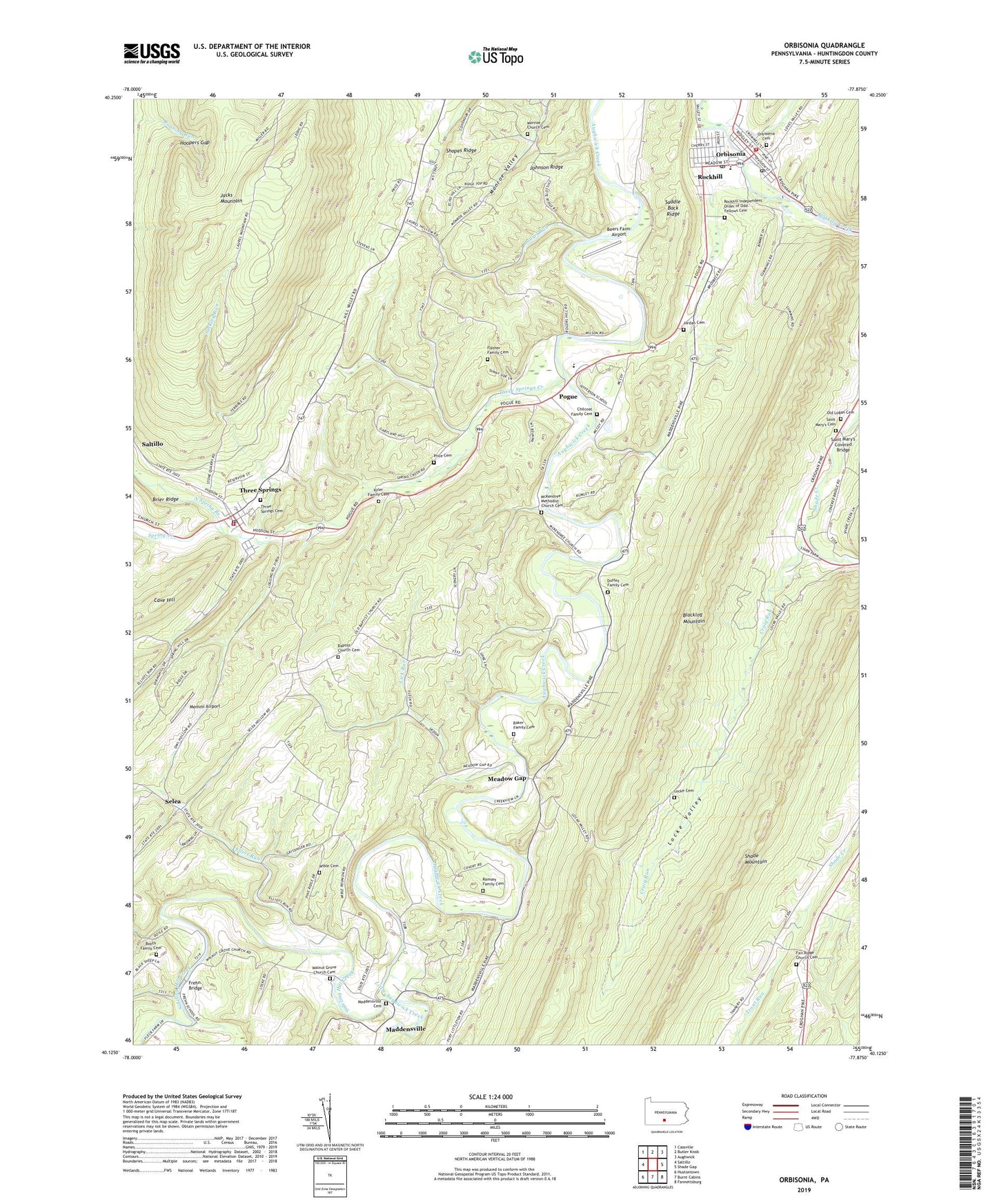
2023 topographic map quadrangle Orbisonia in the state of Pennsylvania. Scale: 1:24000. Based on the newly updated USGS 7.5' US Topo map series, this map is in the following counties: Huntingdon. The map contains contour data, water features, and other items you are used to seeing on USGS maps, but also has updated roads and other features. This is the next generation of topographic maps. Printed on high-quality waterproof paper with UV fade-resistant inks.
Quads adjacent to this one:
West: Saltillo
Northwest: Cassville
North: Butler Knob
Northeast: Aughwick
East: Shade Gap
Southeast: Fannettsburg
South: Burnt Cabins
Southwest: Hustontown
This map covers the same area as the classic USGS quad with code o40077b8.
Contains the following named places: Baker Family Cemetery, Baptist Church Cemetery, Beers Farm Airport, Booth Family Cemetery, Borough of Orbisonia, Borough of Rockhill, Borough of Three Springs, Chilcoat Family Cemetery, Chilcote Corner, Craig Run, Duffey Family Cemetery, Elliot Run, Fair Ridge Church, Fair Ridge Church Cemetery, Flasher Family Cemetery, Frehn Bridge, Hill Valley Church, Hoopers Gap, IBM Distribution Center Heliport, Jefferson School, Johnson Ridge, Jordan Cemetery, Kyler Family Cemetery, Laurel Grove School, Laurel Run, Lick Run, Little Aughwick Creek, Locke Cemetery, Locke Valley, Madden School, Maddensville, Maddensville Cemetery, McKendree Church, McKendree Methodist Church Cemetery, Meadow Gap, Memmi Airport, Mentzer, Monroe Church, Monroe Church Cemetery, Mount Carmel Church, North Spring Branch, Old Baptist Church, Old Logan Cemetery, Orbisonia, Orbisonia / Rockhill Volunteer Fire Company Station 9, Orbisonia Cemetery, Orbisonia Post Office, Pleasant Bank School, Pleasant Hill School, Pogue, Price Cemetery, Ramsey Family Cemetery, Rockhill, Rockhill Furnace Post Office, Rockhill Independent Order of Odd Fellows Cemetery, Saddle Back Ridge, Saint Mary's Cemetery, Saint Marys Church, Saint Mary's Covered Bridge, Selea, Shopes Ridge, Sideling Hill Creek, Sinking Run, Southern Huntingdon County High School, Spring Creek, State Game Lands Number 81, State Game Lands Number 99, Sugar Grove Church, Sugar Grove School, Three Springs, Three Springs Area Ambulance Service 1200, Three Springs Cemetery, Three Springs Creek, Three Springs Post Office, Three Springs Volunteer Fire Company Station 12, Township of Cromwell, Township of Springfield, Walnut Grove Church, Walnut Grove Church Cemetery, Whitsel School, Wible Cemetery, Wible Corner, Wood-Cutting School, ZIP Codes: 17249, 17264