MyTopo
Philipsburg Pennsylvania US Topo Map
Couldn't load pickup availability
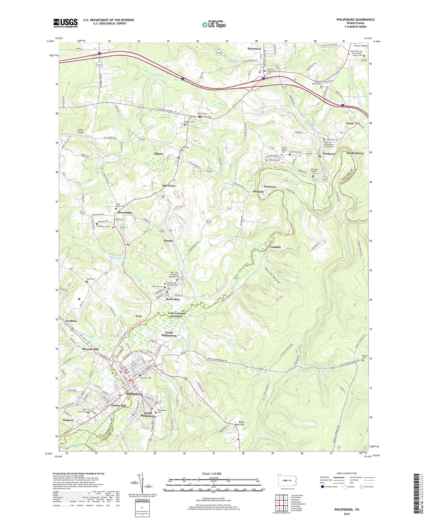
2019 topographic map quadrangle Philipsburg in the state of Pennsylvania. Scale: 1:24000. Based on the newly updated USGS 7.5' US Topo map series, this map is in the following counties: Clearfield, Centre. The map contains contour data, water features, and other items you are used to seeing on USGS maps, but also has updated roads and other features. This is the next generation of topographic maps. Printed on high-quality waterproof paper with UV fade-resistant inks.
Quads adjacent to this one:
West: Wallaceton
Northwest: Lecontes Mills
North: Frenchville
Northeast: Karthaus
East: Black Moshannon
Southeast: Port Matilda
South: Sandy Ridge
Southwest: Houtzdale
Contains the following named places: Albert Airport, Allport, Allport Cemetery, Allport Census Designated Place, Allport Post Office, Ashcroft Cemetery, Barlow Hollow, Black Bear Hill, Black Bear Run, Black Bear Trail, Black Oak School, Borough of Chester Hill, Borough of Philipsburg, Borough of South Philipsburg, Boy Scouts of America Camp, Brown Number 5 Mine Station, Butler Cemetery, Casanova, Casanova Census Designated Place, Chapel of the Good Shepherd, Chester Hill, Chester Hill Borough Police Department, Chester Hill Hose Company Station 14, Coaldale, Cold Stream, Cuba Mine, Cuba Mines, Emigh Lake, Emigh Run, Flat Run, Forest, Forest Baptist Cemetery, Graham, Grandview Cemetery, Hawk Run, Hawk Run Census Designated Place, Hawk Run Post Office, Hope Fire Company 11, Hope School, Huckenberry, Hudson, Hunter Cemetery, Hunter School, Immanuel Cemetery, Kylertown, Kylertown Census Designated Place, Kylertown Post Office, Kylertown Presbyterian Cemetery, Lanse, Lanse Post Office, Laurel Run, Little Laurel Run, Loch Lomond Junction, Messiah Baptist Cemetery, Messiah Church, Morris Township Volunteer Fire Company Station 17, Morrisdale, Morrisdale Census Designated Place, Morrisdale Dam, Morrisdale Post Office, Moshannon Valley Correctional Institution, Moshannon Valley Emergency Medical Services Company 23, Munson, North Lincoln Hill Elementary School, North Philipsburg, North Philipsburg Census Designated Place, Oak Grove, Old Cemetery, Old Union Cemetery, Onemile Run, Pardee, Pardee School, Pennsylvania State Police Troop G Phillipsburg Station, Perks Cemetery, Philipsburg, Philipsburg Cemetery, Philipsburg Elementary School, Philipsburg Junior High School, Philipsburg Post Office, Philipsburg-Osceola High School, Pleasant Hill, Recreation Dam, Reliance Fire Company 12, Rusnak Mine, Saint Agnes Cemetery, Saint John the Baptist Orthodox Cemetery, Saint Johns Cemetery, Saint Johns Church, Saint Peter and Paul Catholic Church Cemetery, Saints Peter and Paul Cemetery, SJA Heliport, Sons of Israel Congregation Hebrew Cemetery, South Philipsburg, South Philipsburg Census Designated Place, State Game Lands Number 78, Sulphur Run, Township of Morris, Troy, Unknown Catholic Cemetery, Unknown Cemetery, West Branch Elementary School, West Branch High School, Wilburne Station, Winburne, Winburne Post Office, Winburne Presbyterian Church Cemetery, Winburne Volunteer Fire Company Station 18, Wolf Run, WPHB-AM (Phillipsburg), ZIP Codes: 16821, 16840, 16847, 16860, 16879