MyTopo
Sharon East Pennsylvania US Topo Map
Couldn't load pickup availability
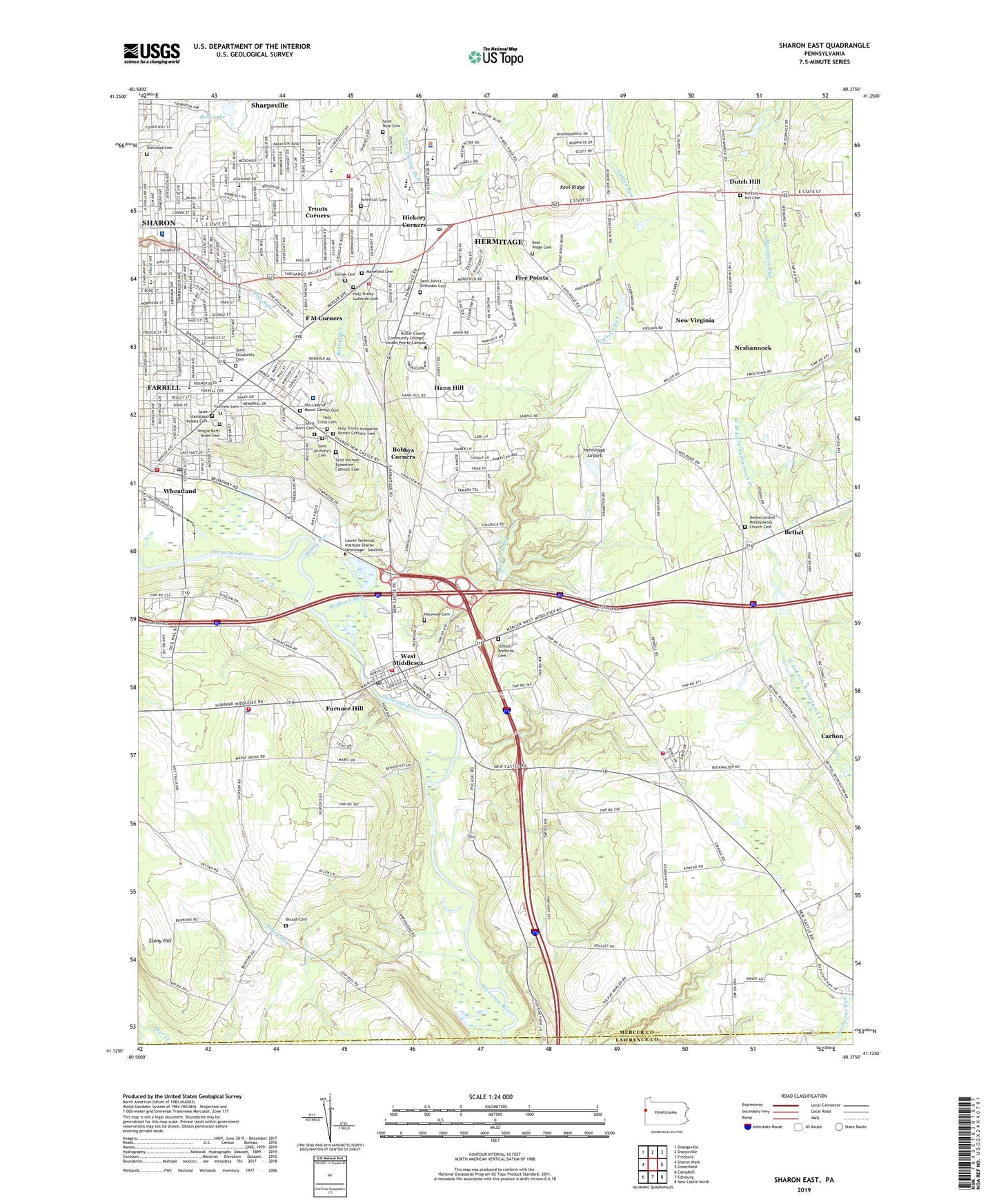
2023 topographic map quadrangle Sharon East in the state of Pennsylvania. Scale: 1:24000. Based on the newly updated USGS 7.5' US Topo map series, this map is in the following counties: Mercer, Lawrence. The map contains contour data, water features, and other items you are used to seeing on USGS maps, but also has updated roads and other features. This is the next generation of topographic maps. Printed on high-quality waterproof paper with UV fade-resistant inks.
Quads adjacent to this one:
West: Sharon West
Northwest: Orangeville
North: Sharpsville
Northeast: Fredonia
East: Greenfield
Southeast: New Castle North
South: Edinburg
Southwest: Campbell
This map covers the same area as the classic USGS quad with code o41080b4.
Contains the following named places: America's Cemetery, Bartman Elementary School, Bethel, Bethel United Presbyterian Church Cemetery, Beulah Cemetery, Bobby Run, Bobbys Corners, Borough of West Middlesex, Borough of Wheatland, Buhl Lake, Buhl Park, Carbon, Central Church, City of Farrell, City of Hermitage, City of Sharon, Dutch Hill, Eckles School, Elite Emergency Medical Services, F M Corners, Fairview Cemetery, Farrell, Farrell Area High School, Five Points, Furnace Hill, Gamble School, Hadley School, Hann Hill, Haywood Cemetery, Hermitage, Hermitage Airport, Hermitage Fire Department Station 93 - 1, Hermitage Fire Department Station 93 - 3, Hermitage Post Office, Hermitage School, Hickory Corners, Hickory High School, Hickory Hill Cemetery, Hogback Run, Holy Cross Cemetery, Holy Trinity Hungarian Roman Catholic Cemetery, Holy Trinity Lutheran Cemetery, Jefferson School, Keel Ridge, Keel Ridge Cemetery, McGonigle Ambulance Service, Morefield Cemetery, Musser Elementary School, Neshannock, New Virginia, Oakland Avenue Church, Oakland Station, Oakwood Cemetery, Our Lady of Mount Carmel Cemetery, Pargney School, Prospect School, Saint Alberts School, Saint Ann's Cemetery, Saint Anthony's Cemetery, Saint Anthonys Church, Saint Elizabeths Cemetery, Saint Johns Church, Saint John's Orthodox Cemetery, Saint Michael Byzantine Catholic Cemetery, Saint Pauls Church, Saint Rose Cemetery, Saint Stanislaus Kostka Cemetery, Sharon, Sharon Airport, Sharon High School, Sharon Regional Medical Center, Shehango Township Volunteer Fire Department Station 79 2, Shenango Township Mercer County Police Department, Shenango Township Volunteer Fire Department Station 79, Slovak Cemetery, Stony Hill, Temple Beth Israel Cemetery, Thornton School, Township of Shenango, Trouts Corners, Turkey Run, United Brethren Cemetery, University of Pennsylvania Medical Center Horizon Shenango Valley, VFW Golf Course, Wengler Avenue School, West Middlesex, West Middlesex Post Office, West Middlesex Volunteer Fire Department Station 74, Wheatland, Wheatland Post Office, Wheatland Volunteer Fire Department Station 72, WPIC-AM (Sharon), WYFM-FM (Sharon), ZIP Codes: 16121, 16146, 16148, 16159, 16161