MyTopo
Williamsport Pennsylvania US Topo Map
Couldn't load pickup availability
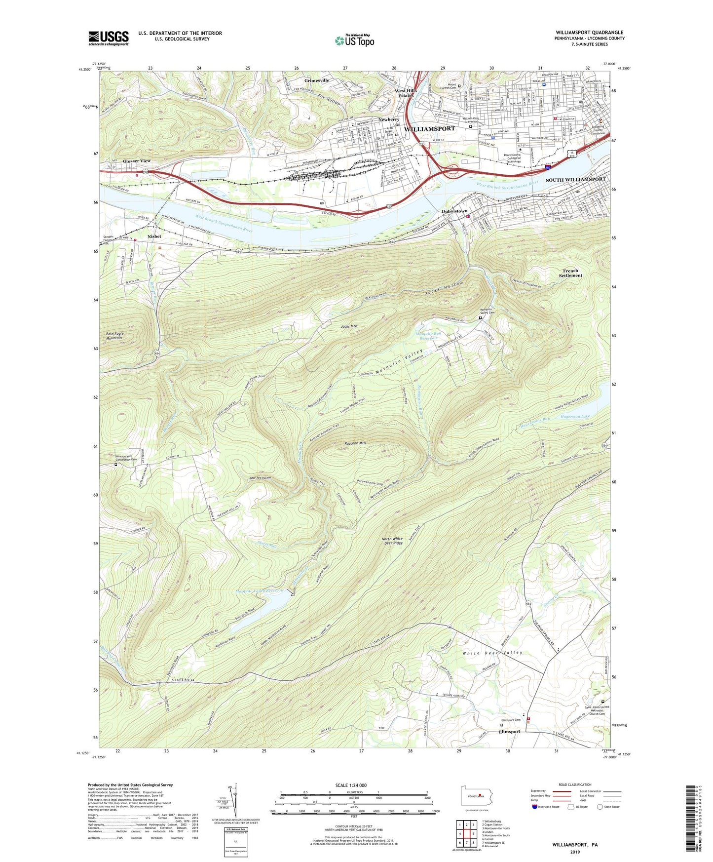
2019 topographic map quadrangle Williamsport in the state of Pennsylvania. Scale: 1:24000. Based on the newly updated USGS 7.5' US Topo map series, this map is in the following counties: Lycoming. The map contains contour data, water features, and other items you are used to seeing on USGS maps, but also has updated roads and other features. This is the next generation of topographic maps. Printed on high-quality waterproof paper with UV fade-resistant inks.
Quads adjacent to this one:
West: Linden
Northwest: Salladasburg
North: Cogan Station
Northeast: Montoursville North
East: Montoursville South
Southeast: Allenwood
South: Williamsport SE
Southwest: Carroll
Contains the following named places: Abraham Lincoln School, Andrew Jackson School, Arch Street Cemetery, Bear Pen Hollow, Bender Run, Borough of Duboistown, Borough of South Williamsport, Bowman Field, Brandon Park, Center City Post Office, City of Williamsport, Culbertson Trail, Daniel Webster School, Daugherty Run, David Person Field, Detwiler Planetarium, Diamond Square, Doctor and Mrs Fletcher Bliss Forrest Hall, Duboistown, Duboistown Fire Department Station 8, Elimsport, Elimsport Cemetery, Fox Hollow, French Settlement, George Washington School, Glosser View, Grimesville, Hagerman Lake, Heim Biology and Chemistry Building, Henry Clay School, Hillside School, Immaculate Conception Cemetery, Immaculate Conception Church, Immaculate Conception School, Independent Fire Company 1 of South Williamsport, Jacks Hollow, Jacks Mountain, Jackson Playground, John G Snowden Memorial Library, Lose School, Lycoming County Sheriff's Office, Lycoming Creek, Mary Ellen Williams Hall, Mary L Welch Theatre, Mosquito Creek, Mosquito Run Dam, Mosquito Run Reservoir, Mosquito Valley, Mosquito Valley Cemetery, Mosquito Valley Reservoir, Mount Carmel Cemetery, Newberry, Newberry Post Office, Nisbet, Nisbet Volunteer Fire Company Station 7, Pennington Lounge, Pennsylvania College of Technology, Raccoon Mountain, Remington Run, Reverend Benjamin H Crever Hall, Rich Hall, Riedy School, Robert L Shangraw Athletic Complex, Saint Johns United Methodist Church Cemetery, Sanders Family Plot, Shires Run, South Williamsport Post Office, Southern Avenue School, State Game Lands Number 126, Stevens School, Stewart School, Streeter College Store, Susquehanna State Park, Theodore Roosevelt Junior High School, Tiadaghton State Forest, Township of Armstrong, Township of Bastress, Transeau School, Valley School, Washington Township Volunteer Fire Company Station 21, Ways Garden Park, Wendle Hall, Wertz Student Center, West Hills Estates, William King Gravesite, Williamsport, Williamsport Bureau of Fire Station 1, Williamsport High School, Williamsport Hospital and Medical Center, Williamsport Hospital Heliport, Williamsport Police Department, Williamsport Post Office, Woodward Township Volunteer Fire Company Station 2, WRAK-AM (Williamsport), WWAS-FM (Williamsport), WWPA-AM (Williamsport), ZIP Code: 17702