MyTopo
Cogan Station Pennsylvania US Topo Map
Couldn't load pickup availability
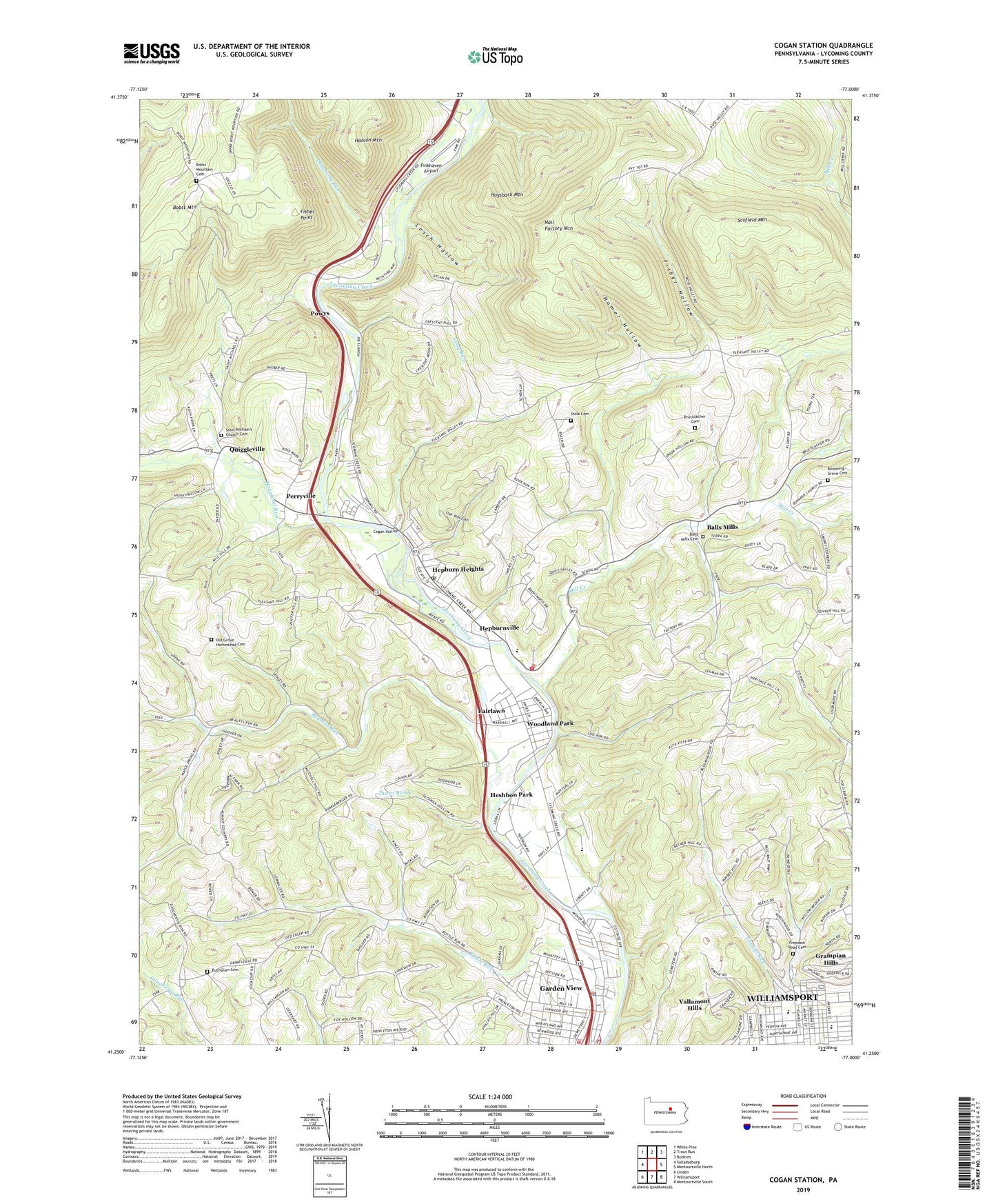
2023 topographic map quadrangle Cogan Station in the state of Pennsylvania. Scale: 1:24000. Based on the newly updated USGS 7.5' US Topo map series, this map is in the following counties: Lycoming. The map contains contour data, water features, and other items you are used to seeing on USGS maps, but also has updated roads and other features. This is the next generation of topographic maps. Printed on high-quality waterproof paper with UV fade-resistant inks.
Quads adjacent to this one:
West: Salladasburg
Northwest: White Pine
North: Trout Run
Northeast: Bodines
East: Montoursville North
Southeast: Montoursville South
South: Williamsport
Southwest: Linden
This map covers the same area as the classic USGS quad with code o41077c1.
Contains the following named places: Balls Mills, Balls Mills Cemetery, Beautys Run, Bethel Church, Blooming Grove Cemetery, Blooming Grove Meetinghouse, Bobst Mountain, Bobst Mountain Cemetery, Bodst Mountain School, Bottle Run, Bottle Run School, Brandon Park, Brucklacher Cemetery, Buchanan Cemetery, Buchanan Church, Cochran School, Cogan Station, Cogan Station Post Office, Consistory Field, Crescent School, Curtin School, Daugherty Run, Eagle Church, Eagle School, Fairlawn, Falls Factory School, Finkhaven Airport, Fisher Hollow, Fisher Point, Forest Glen School, Franklin School, Freedom Road Cemetery, Garden View, Garden View Census Designated Place, Grafius Run, Grampian Hills, Haleeka, Hanlon Mountain, Hepburn Church, Hepburn Heights, Hepburn Lycoming School, Hepburn Township Volunteer Fire Company Station 15, Hepburnville, Hesburn School, Heshbon Park, Hoagland Run, Hogsback Mountain, Homer Hollow, Klumps School, Knight Dam, Long Run, Losch Hollow, Lycoming Centre Church, Lycoming County, Lycoming Valley Middle School, Maple Springs Church, Mill Creek, Nail Factory Mountain, Oak Grove Church, Oak Grove School, Old Grove Homestead Cemetery, Old Lycoming Township Police Department, Old Lycoming Township Volunteer Fire Company Station 14, Perryville, Pleasant Hill School, Pleasant Valley School, Powys, Quiggleville, Round Hills School, Saint Michaels Church, Saint Michael's Church Cemetery, Scofield Mountain, Stolz Cemetery, Thorn Brook, Township of Hepburn, Township of Lycoming, Township of Old Lycoming, Vallamont Hills, Wildwood Cemetery, WLYC-AM (Williamsport), Wolf Run, Woodland Park, ZIP Code: 17728