MyTopo
Saylorsburg Pennsylvania US Topo Map
Couldn't load pickup availability
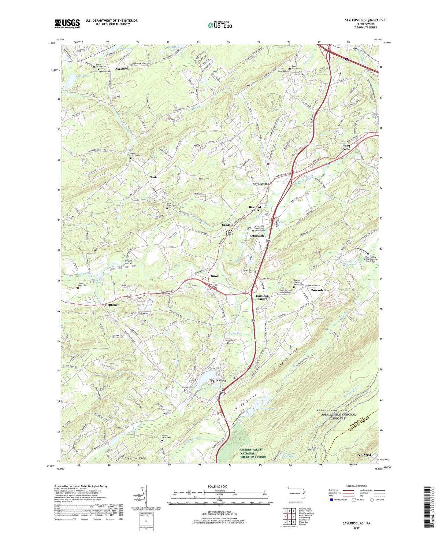
2023 topographic map quadrangle Saylorsburg in the state of Pennsylvania. Scale: 1:24000. Based on the newly updated USGS 7.5' US Topo map series, this map is in the following counties: Monroe, Northampton. The map contains contour data, water features, and other items you are used to seeing on USGS maps, but also has updated roads and other features. This is the next generation of topographic maps. Printed on high-quality waterproof paper with UV fade-resistant inks.
Quads adjacent to this one:
West: Brodheadsville
Northwest: Pocono Pines
North: Mount Pocono
Northeast: East Stroudsburg
East: Stroudsburg
Southeast: Bangor
South: Wind Gap
Southwest: Kunkletown
This map covers the same area as the classic USGS quad with code o40075h3.
Contains the following named places: Appenzell, Appenzell Cemetery, Appenzell Creek, Blue Ridge Hook and Ladder Fire Company Station 23 Saylorsburg, Blue Ridge Hook and Ladder Fire Company Station 23 Snydersville, Bossardsville, Bossert - Heller Family Cemetery, Brainerd Center, Bull Run School, Bushs Golf Course, Camp Akiba, Camp Akiba Dam, Camp Dent, Cherry Ridge, Cherry Valley Airport, Cherry Valley Church, Cherry Valley National Wildlife Refuge, Cherry Valley United Methodist Church Cemetery, Christ Hamilton Lutheran Cemetery, Custards Cemetery, Deer Run Trailer Park, Evergreen Acres, Fawn Valley Mobile Home Park, Frances School, Gower Cemetery, Green Ridge Cemetery, Grubers Lake, Grubers Lake Dam, Hamilton Hills South, Hamilton School, Hamilton Square, Hamilton Township Elementary School, Hiawatha Lake, Indian Spring Run Pond, Jackson, Jackson Church, Kellersville, Kellersville Esker, Kellersville Methodist Church Cemetery, Kettle Creek, Lake Akiba, Lake Creek, Lake View Cemetery, Lake Watawah, McIlhaney, McMichael Dam, Mechanicsville, Monroe County Correctional Facility, Mount Calvary Cemetery, Mount Eaton Cemetery, Mount Zion Cemetery, Nazareth Reservoir, Neola, Pegasus Air Park, Pinemere Camp, Pinemere Lake, Pleasant Valley Manor, Ross Common Creek, Saint Johns Cemetery, Saint John's Cemetery, Saint Johns Church, Saint Lukes Church, Saint Marks Church, Sandhill, Saylors Lake, Saylorsburg, Saylorsburg Census Designated Place, Saylorsburg Post Office, Sciota, Sciota Post Office, Simmons Dam, Snydersville, Spring Run, State Game Lands Number 186, Stone Creek Dam, Stroudsburg Quarry, Township of Hamilton, Township of Ross, Wesley Chapel, Wigwam Run, Witmer Dam, Witmers Lake, ZIP Codes: 18353, 18354, 18360