MyTopo
Stroudsburg Pennsylvania US Topo Map
Couldn't load pickup availability
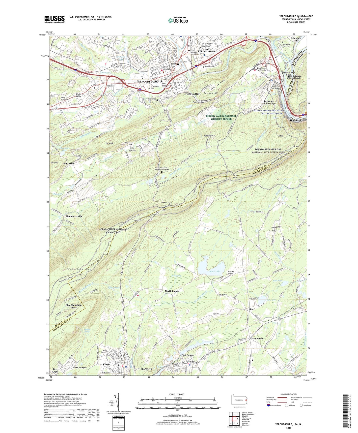
2023 topographic map quadrangle Stroudsburg in the states of Pennsylvania, New Jersey. Scale: 1:24000. Based on the newly updated USGS 7.5' US Topo map series, this map is in the following counties: Northampton, Monroe, Warren. The map contains contour data, water features, and other items you are used to seeing on USGS maps, but also has updated roads and other features. This is the next generation of topographic maps. Printed on high-quality waterproof paper with UV fade-resistant inks.
Quads adjacent to this one:
West: Saylorsburg
Northwest: Mount Pocono
North: East Stroudsburg
Northeast: Bushkill
East: Portland
Southeast: Belvidere
South: Bangor
Southwest: Wind Gap
This map covers the same area as the classic USGS quad with code o40075h2.
Contains the following named places: Abeloff Convocation Center, Ahnert Alumni Center, Arlington Heights, Arlington Lake, Arlington Lake Dam, Bangor Junior-Senior High School, Bear Swamp, Beers Lecture Hall, Big Meadow Run, Blue Mountain Pines, Borough of Delaware Water Gap, Borough of East Bangor, Borough of Roseto, Borough of Stroudsburg, Brodhead Creek, Brodheads Creek Dam, Burial Ground of Friends, Caledonia Creek, Camp Big Pocono, Cherry Creek, Cherry Valley, Cherry Valley Golf Course, Cherry Valley School, Columbia Township Fire Department Station 34, Columbus School, Computing Center, Crystal Hill, D W G Universal Instrument Airport, Dansbury Cemetery, Dansbury Commons, Dave Carllyon Pavilion, Delaware Water Gap, Delaware Water Gap Cemetery, Delaware Water Gap Fire Department Station 26, Delaware Water Gap Police Department, Delaware Water Gap Post Office, Delaware Water Gap Station, Delaware Water Gap Toll Bridge, DeNike Center for Human Resources, Dunnfield Creek, Dutotsburg, East Bangor, East Bangor Borough Police Department, East Bangor Fire Department Station 31, East Fork Martins Creek, East Stroudsburg, East Stroudsburg Post Office, East Stroudsburg University of Pennsylvania, Echo Lake, Echo Lake Dam, Ellen Martin Stadium, Five Points, Five Points Elementary School, Flagler - Metzger Center, Flagler Run, Fox Gap, Foxtown Gap, Foxtown Hill, Gessner Science Hall, Glen Brook Golf Course, Godfrey Ridge, Hallett's Airport, Hawthorn Residence Hall, Hemlock Residence Hall, Ice-Fish Dam, Indian Chair, Jamesway Plaza, Johnsons Swamp, Keller Church, Kellers Cherry Valley Cemetery, Kemmererville, Kemmererville School, Kemp Library, Kittatinny Mountain, Koehler Fieldhouse and Natatorium, Lake Lenape Cave Shelter, Lake Poco, Lake Poco Dam, LaRue Hall Speech and Hearing Center, Laurel Hill, Laurel Residence Hall, Laurel Swamp, Laurelwood Cemetery, Lehigh Valley Hospital - Pocono, Lenape Lake, Lenape Residence, Linden Residence Hall, Little Pocono Creek, Little Sambo Creek, Loder School, Lower Dam, Marshalls Creek, Martins Creek Dam, McGarry Communication Center, McMichael Creek, Millers Egg Ranch, Minisink Hills, Minsi Lake, Minsi Lake Dam, Minsi Residence Hall, Mitterling Athletic Field, Monroe County Sheriff's Office, Monroe Residence Hall, Moore Biology Hall, Morey Elementary School, Mount Minsi, Mountain Run, Muffley Spring, New Catholic Cemetery, North Bangor, North Bangor Station, North Bangor Volunteer Fire Department Station 39, Notre Dame Elementary School, One College Circle, Pahaquarry, Paper Mill Pond, Pine Grove Lake, Pocono Creek, Pocono Plaza, Poplar Valley, Poplar Valley Church, Poplar Valley School, Poplar Valley United Methodist Church Cemetery, Prospect Cemetery, Quaker Plain School, Quarry Junction, Quarry Junction Station, Ramsey Elementary School, Reibman Administration Building, Rosenkrans Hall East, Rosenkrans Hall West, Roseto, Roseto Borough Police Department, Roseto Presbyterian Cemetery, Saint Joseph Church, Saint Marks Church, Saint Marks Church Cemetery, Saint Matthew School, Saint Matthew's Cemetery Number 1, Saint Pauls Church, Schaeffer Church, Schellenbergers Island, Shafer Schoolhouse Cemetery, Shawnee Inn Golf Course, Shawnee Residence Hall, Spoke Factory School, State Teachers College, Stier, Stoefflet Pond, Stormville, Stroud Area Regional Police Department, Stroud Hall, Stroud Mall, Stroud Township Volunteer Fire Department Station 37, Stroudsburg, Stroudsburg Cemetery, Stroudsburg Fire Department Station 38 - Chemical Company 1 - Phoenix Company 2, Stroudsburg High School, Stroudsburg Post Office, Suburban Emergency Medical Services, The Big Offset, The Knob, The Little Offset, Totts Gap, Totts Gap School, Township of Upper Mount Bethel, Upper Hand, Water Gap Golf Course, WESS-FM (East Stroudsburgh), West Bangor, West Fork Martins Creek, Wolbers Tennis Courts, Wolf School Number One, Wolf School Number Two, WVPO-AM (Stroudsburg), WVPO-FM (Stroudsburg), Wyomissing Camp, Zimbar-Liljenstein Hall, Zimbbar Athletic Field, ZIP Code: 18327