MyTopo
Attleboro Massachusetts US Topo Map
Couldn't load pickup availability
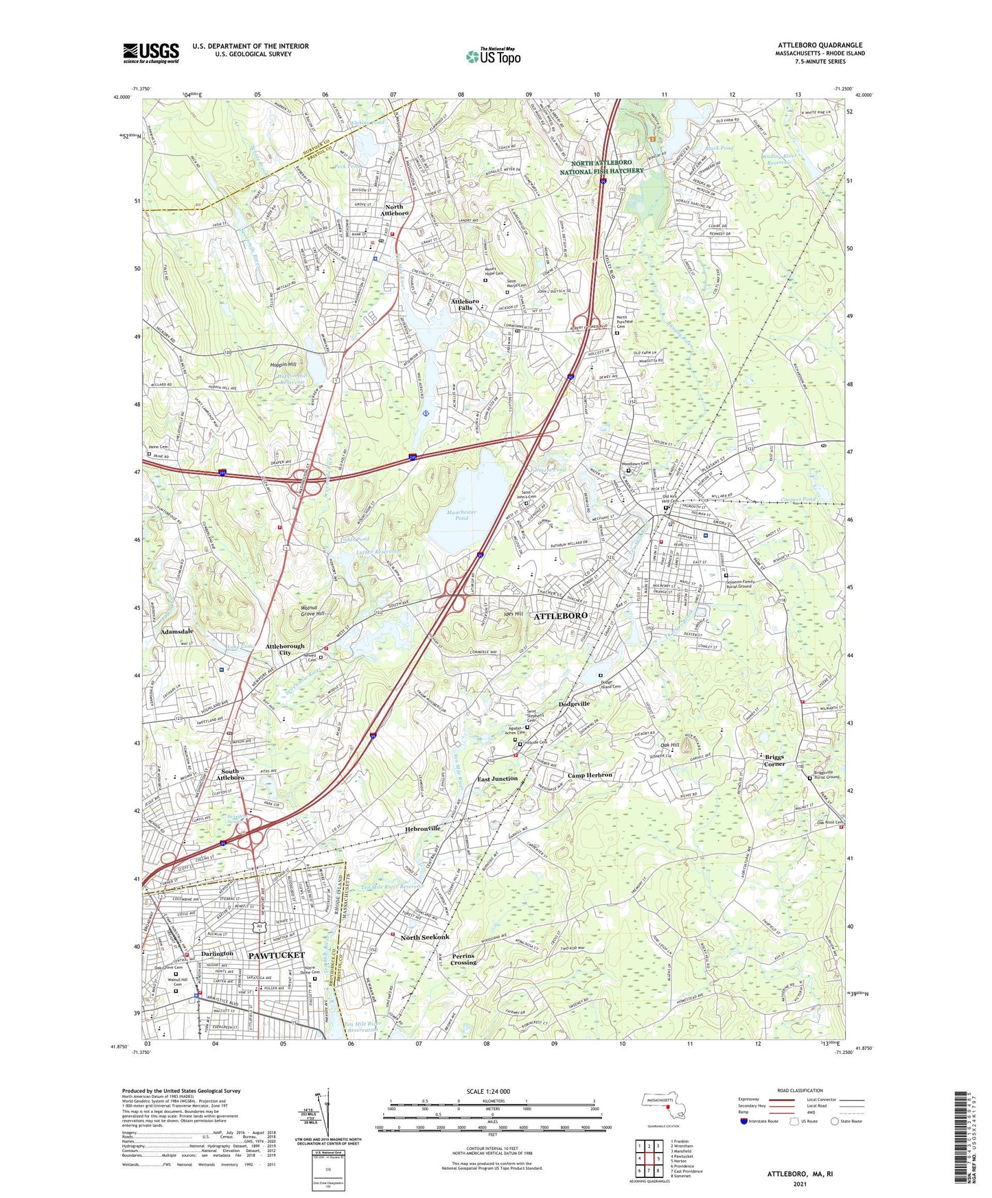
2024 topographic map quadrangle Attleboro in the states of Massachusetts, Rhode Island. Scale: 1:24000. Based on the newly updated USGS 7.5' US Topo map series, this map is in the following counties: Bristol, Providence, Norfolk. The map contains contour data, water features, and other items you are used to seeing on USGS maps, but also has updated roads and other features. This is the next generation of topographic maps. Printed on high-quality waterproof paper with UV fade-resistant inks.
Quads adjacent to this one:
West: Pawtucket
Northwest: Franklin
North: Wrentham
Northeast: Mansfield
East: Norton
Southeast: Somerset
South: East Providence
Southwest: Providence
Contains the following named places: Adamsdale, Agnes E Little School, Allen Avenue School, Arbour - Fuller Hospital, Attleboro, Attleboro City Hall, Attleboro Falls, Attleboro Falls Post Office, Attleboro Fire Department Briggs Corner, Attleboro Fire Department South Attleboro, Attleboro Fire Department Station 1 Headquarters, Attleboro Fire Department Twin Village, Attleboro High School, Attleboro Police Department, Attleboro Post Office, Attleboro Public Library, Attleboro Sewage Disposal, Attleboro Station, Attleborough City, Bishop Feeham High School, Black Pond, Bliss Brook, Bliss School, Boulevard Plaza Shopping Center, Briggs Corner, Bristol Place Shopping Center, Bungay River, Camp Hebron, Camp Herbron, Camp Shady Pines, Capron Park, Central Shopping Center, Child Care Connection, City of Attleboro, Coopers Pond, Curvin McCabe School, Cushman Church, Cyril K Brennan Middle School, Darlington, Darlington Congregational Church, Dayspring Christian School, Dodgeville, Dodgeville Pond, Dodgeville Pond Dam, East Junction, Emerald Square, Emerald Square Shopping Center, Epworth United Methodist Church, Falls Pond, Falls Pond Dam, Falls Pond Seaplane Base, Farmers Pond, Farmers School, Flora S Curtis Memorial School, Fourmile Brook, Fuller Memorial Sanitarium, Goff Junior High School, Grace Baptist Christian Academy, Greenwood Lake, Greenwood Lake Dam, Hamilton Country Day School, Hebron Mill Pond Dam, Hebronville, Highland Country Club, Hill-Roberts Elementary School, Hillside Cemetery, Hoppin Hill, Hoppin Hill Reservoir, Hyman Fine Elementary School, Ides Hill, Joseph Jenks Junior High School, Joseph W Martin Junior Elementary School, Kings Shopping Center, La Salette Seminary, Lake Como, Lincoln School, Locust Valley Country Club, Luther Reservoir, Luther Reservoir Dam, Manchester Pond, Manchester Pond Dam, Manchester Pond East Dike, Manchester Pond Reservoir, Mechanics Pond, Mechanics Pond Dam, MedTech Ambulance Service, Mount Hope Cemetery, Newell Burying Ground Cemetery, North Attleboro, North Attleboro Fire Department Station 1 Headquarters, North Attleboro Fire Department Station 3, North Attleboro High School, North Attleboro Junior High School, North Attleboro National Fish Hatchery, North Attleboro Police Department, North Attleboro Post Office, North Attleborough Center Census Designated Place, North Attleborough Early Learning Center, North Purchase Cemetery, North Seekonk, North Seekonk Census Designated Place, North Seekonk School, Notre Dame Cemetery, Oak Grove Cemetery, Oak Hill, Oldtown School, Orrs Pond, Orrs Pond Dam, Our Lady of Consolation Church, Our Lady of Consolation School, Paine Cemetery, Pawtucket Fire Department Station 4, Peck Pond, Perrins Crossing, Peter Thacher Elementary School, Potter-Burns School, Rehoboth Fire Department Station 2, Richardson School, Robert J Coelho Middle School, Roosevelt Avenue School, Sacred Heart School, Saint Cecilia School, Saint Johns School, Saint Josephs Rectory, Saint Josephs School, Saint Leo Church, Saint Leo School, Saint Martins School, Saint Mary Sacred Heart School, Saint Marys Cemetery, Saint Marys School, Saint Stephen's Cemetery, Sandys Shopping Plaza, Scotts Brook, Seekonk Fire Department Station 2, Sevenmile River, SMARTS Collaborative School, South Attleboro, South Attleboro Junior High School, South Attleboro Post Office, South Attleboro Station, Studley School, Sturdy Memorial Hospital, Sweedens Swamp, Ten Mile River Dam, Ten Mile River Reservation, Ten Mile River Reservoir, Thacher Brook, Tiffany School, Todds Pond, Town of North Attleborough, Wading River Dam, Wading River Reservoir, Walnut Grove Hill, Walnut Hill Cemetery, Wamsutta Middle School, WARA-AM (Attleboro), Washington Plaza, Washington School, Whiting Pond, Whiting Pond Dam, Willett School, Woodcock School, Woodlawn Cemetery, WPRI-TV (Providence), ZIP Codes: 02703, 02760, 02763, 02861