MyTopo
Greenwood South Carolina US Topo Map
Couldn't load pickup availability
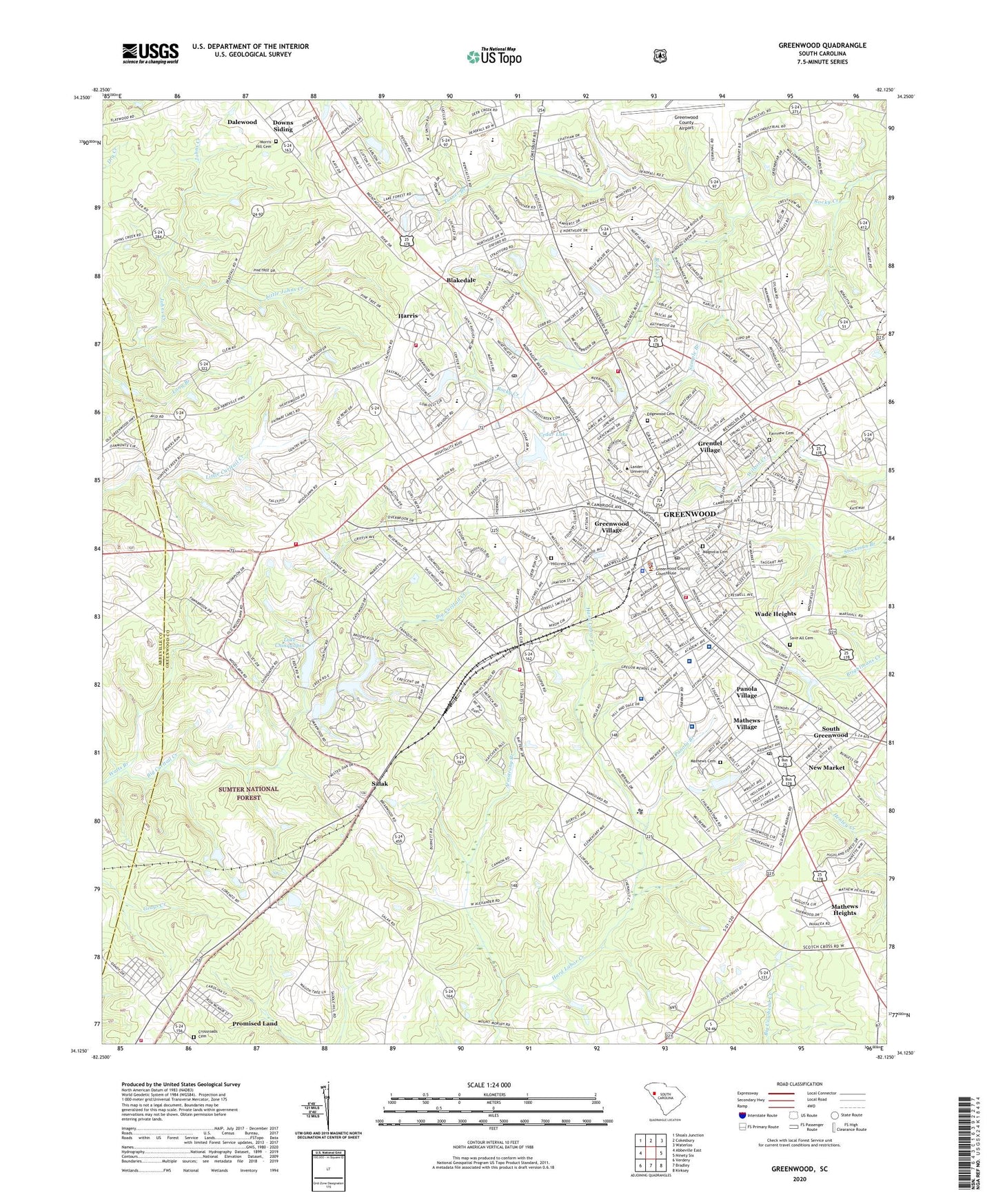
2020 topographic map quadrangle Greenwood in the state of South Carolina. Scale: 1:24000. Based on the newly updated USGS 7.5' US Topo map series, this map is in the following counties: Greenwood, Abbeville. The map contains contour data, water features, and other items you are used to seeing on USGS maps, but also has updated roads and other features. This is the next generation of topographic maps. Printed on high-quality waterproof paper with UV fade-resistant inks.
Quads adjacent to this one:
West: Abbeville East
Northwest: Shoals Junction
North: Cokesbury
Northeast: Waterloo
East: Ninety Six
Southeast: Kirksey
South: Bradley
Southwest: Verdery
Contains the following named places: Abbeville-Greenwood Regional Library, Abney Missionary Baptist Church, Alderman Sanitarium, Anderson Plaza Shopping Center, Armstrong Branch, Augusta Fields, Avondale, Belle Meade, Beulah Church, Blake School, Blakedale, Breckridge, Brewer Hospital, Brewer Intermediate School, Briarcliff, Brookside, Bullock, Callie Self Memorial Baptist Church, Calvary Church, Cambridge Academy, Canterbury, Cedar Lake, Central School, Cherokee Hills, Chinquapin, Church of Christ, City of Greenwood, Connie Maxwell Baptist Church, Coronaca Army Air Field, Cothran, Crestview, Cross Roads Church, Cross Roads School, Crosscreek Mall Shopping Center, Crossroads Cemetery, Crossroads Church, Dalewood, Davis School, Downs Siding, Druid Hills, Dunham Temple Christian Methodist Episcopal Church, Durst Avenue Church of God, Dykes School, East End Graded School, East End School, East Side Church, Edgemere, Edgewood Cemetery, Ellenwood Acres, Emanuel Church, Emerald Junior High School, Episcopal Church of the Resurrection, Fairview Cemetery, Fawn Brook, First Assembly of God Church, First Associate Reformed Presbyterian Church, First Baptist Church, First Mount Moriah Church, First Presbyterian Church, Flatwood School, Forest Hills, Forest Lake, Galloway Memorial United Methodist Church, Glendale, Good Hope School, Greenwood, Greenwood City Fire Department Station 3, Greenwood Country Club, Greenwood County, Greenwood County Airport, Greenwood County Courthouse, Greenwood County Emergency Medical Services, Greenwood County Jail, Greenwood Division, Greenwood Endoscopy Center, Greenwood Fire Department Station 1, Greenwood Fire Department Station 2, Greenwood Golf Club, Greenwood High School, Greenwood High Vocational Center, Greenwood Hospital, Greenwood Nursing Center, Greenwood Plaza Shopping Center, Greenwood Police Department, Greenwood Professional Park, Greenwood Recreation Center, Greenwood Regional Rehabilitation Hospital, Greenwood Village, Grendel Village, Grenole School, Hampton Place Shopping Center, Harris, Harris Baptist Church, Harris United Methodist Church, Highland Forest, Hill and Dale, Hillcrest Cemetery, Holiness Church, Holy Redeemer Pentecostal Holiness Church, Hyde Park, Hype Park Baptist Church, Idlewood, Immanuel Lutheran Church, Jacobs Chapel, Johns Creek Baptist Church, Jordan Street Church, Kimbrook, Lake Chinquapin, Lakeview School, Lakewood Heights, Lander University, Laurel Church, Leslie Primary School, Little Johns Creek, Little Zion Church, Locksley Hall, Lodge Grounds, Long Cane Ranger District Office, Lorenzo, Lowell Street United Methodist Church, Lupo Memorial United Methodist Church, Macedonia Baptist Church, Magnolia Cemetery, Magnolia Post Office, Magnolia Street Graded School, Main Street United Methodist Church, Mars Hill Church, Mathews Cemetery, Mathews Heights, Mathews Primary School, Mathews United Methodist Church, Mathews Village, Maxwell Childrens Home, McCombs, McKissick Memorial Library, Merrywood School, Morris Chapel Baptist Church, Morris Hill Cemetery, Mount Moriah Church, Mount Pisgah African Methodist Episcopal Church, Mount Zion Church, New Jerusalem Deliverance Temple, New Market, New Market Baptist Church, North Creek Shopping Center, North Side Baptist Church, Northfall Acres, Northside Junior High School, Northwest Volunteer Fire Department Station 31, Our Lady of Lourdes Catholic Church, Page Place, Panola Branch, Panola Methodist Church, Panola Village, Pine Grove Hills, Pine Grove School, Pinecrest School, Ponderosa Heights, Promised Land, Promised Land Census Designated Place, Promised Land Fire Department Station 20, Promised Land School, Rice Memorial Church, Rock Creek, Saint Mark United Methodist Church, Saint Marys Roman Catholic Church, Saint Paul Pentescostal Holiness Church, Salak, Sample Branch, Save All Cemetery, Self Regional Healthcare, Sheffield, Smithfield, South Carolina Highway Patrol Troop 2 Post B, South Carolina Noname 24004 D-1260 Dam, South Carolina Noname 24012 D-1267 Dam, South Carolina Noname 24014 D-1268 Dam, South Carolina Noname 24018 D-1272 Dam, South Greenwood, South Greenwood Church of God, South Greenwood Pentecostal Holiness Church, South Main Street Baptist Church, Southside Junior High School, Sproles Recreational Center, Stalnaker Heights, Stockman Park, Surgery Center of the Lakelands, Tabernacle Baptist Church, Taylors Store, The Willows, Timberlake, Tranquil Church, Trinity United Methodist Church, Turner Branch, United House of Prayer, Utopia School, Wade Heights, Watts Branch, WCRS-AM (Greenwood), Wellington Green, Wesleyan Methodist Church, West Side Baptist Church, West Side School, Westgate, Weston Chapel African Methodist Episcopal Church, Westover, WGSW-AM (Greenwood), Windtree, Wisewood, WMTY-AM (Greenwood), WMTY-FM (Greenwood), Woodfields School, Woodlawn, Woodlawn Church, Woodlawn School, WSCZ-FM (Greenwood), ZIP Codes: 29646, 29649