MyTopo
Hartsville North South Carolina US Topo Map
Couldn't load pickup availability
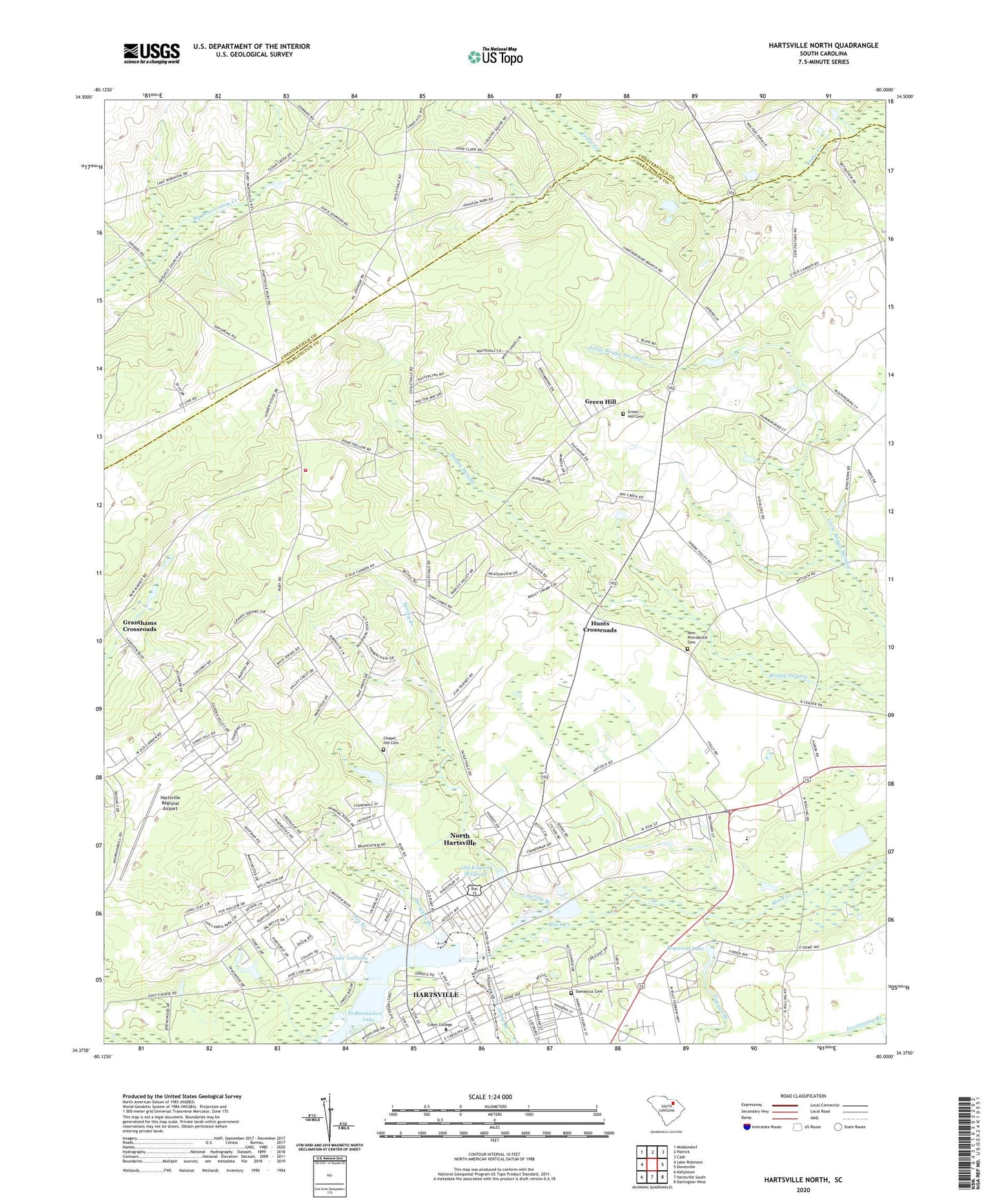
2020 topographic map quadrangle Hartsville North in the state of South Carolina. Scale: 1:24000. Based on the newly updated USGS 7.5' US Topo map series, this map is in the following counties: Darlington, Chesterfield. The map contains contour data, water features, and other items you are used to seeing on USGS maps, but also has updated roads and other features. This is the next generation of topographic maps. Printed on high-quality waterproof paper with UV fade-resistant inks.
Quads adjacent to this one:
West: Lake Robinson
Northwest: Middendorf
North: Patrick
Northeast: Cash
East: Dovesville
Southeast: Darlington West
South: Hartsville South
Southwest: Kellytown
Contains the following named places: Antioch School, Beaver Creek School, Belair Estates, Byerly Hospital, Calvary Church, Chapel Hill Cemetery, Chapel Hill Church, Church of God, Church of the Nazarene, City Sewage Disposal Pond Number One, Club Colony, Cogdell Branch, Coker College, College Heights, Curry Airport, Damascus Cemetery, Darlington County Fire Department Pond Hollow, Dogwood Acres, Dogwood Lake, Dogwood Lake Dam D-3520, Dry Branch, Dunlap Terrace, East Home Avenue Historic District, Emmanuel Baptist Church, Emmanuel School, First Assembly of God Church, First Baptist Church, Fox Hollow, Free Will Church, Glendale, Glendale Acres, Granthams Crossroads, Green Hill, Green Hill Cemetery, Green Hill Church, Hartsville Country Club, Hartsville Lookout Tower, Hartsville Memorial Library, Hartsville Regional Airport, Highland Pond Dam D-3517, Hillcrest, Holiness Church, Hollandia Park, Horsepen Branch, Hunts Crossroads, Kay Branch Church, Kay Branch School, Lake Anthony, Lakeside Church, Lakeview Baptist Church, Lakewood, Lawton Park, Morton Church, New Hope Church, New Market School, New Providence Cemetery, New Providence Church, North Hartsville, North Hartsville Baptist Church, North Hartsville Census Designated Place, North Hartsville Division, North Hartsville Elementary School, Northwood, Old Kilgore Millpond, Piney Plain Church, Pond Hollow Church, Pond Hollow School, Prestwood Country Club, Prestwood Lake, Prestwood Village, Prospect Church, Prospect Church Cemetery, Saint Bartholomews Episcopal Church, Saint Mary the Virgin Mother Catholic Church, Saint Marys School, Sherwood Forest, Snake Branch, Sonavista Elementary School, Sonoco Industrial Waste Dam D-3521, Sonovista Park, South Carolina Noname 16005 Dam, South Carolina Noname 16030 D-3519 Dam, Spring Branch, Sunbar School, Tanglewood, The Church of Jesus Christ of Latter Day Saints, Thornwell School, Town and Country Estates, Wesley United Methodist Church, Whispering Pines Church, Woodbridge, ZIP Code: 29550