MyTopo
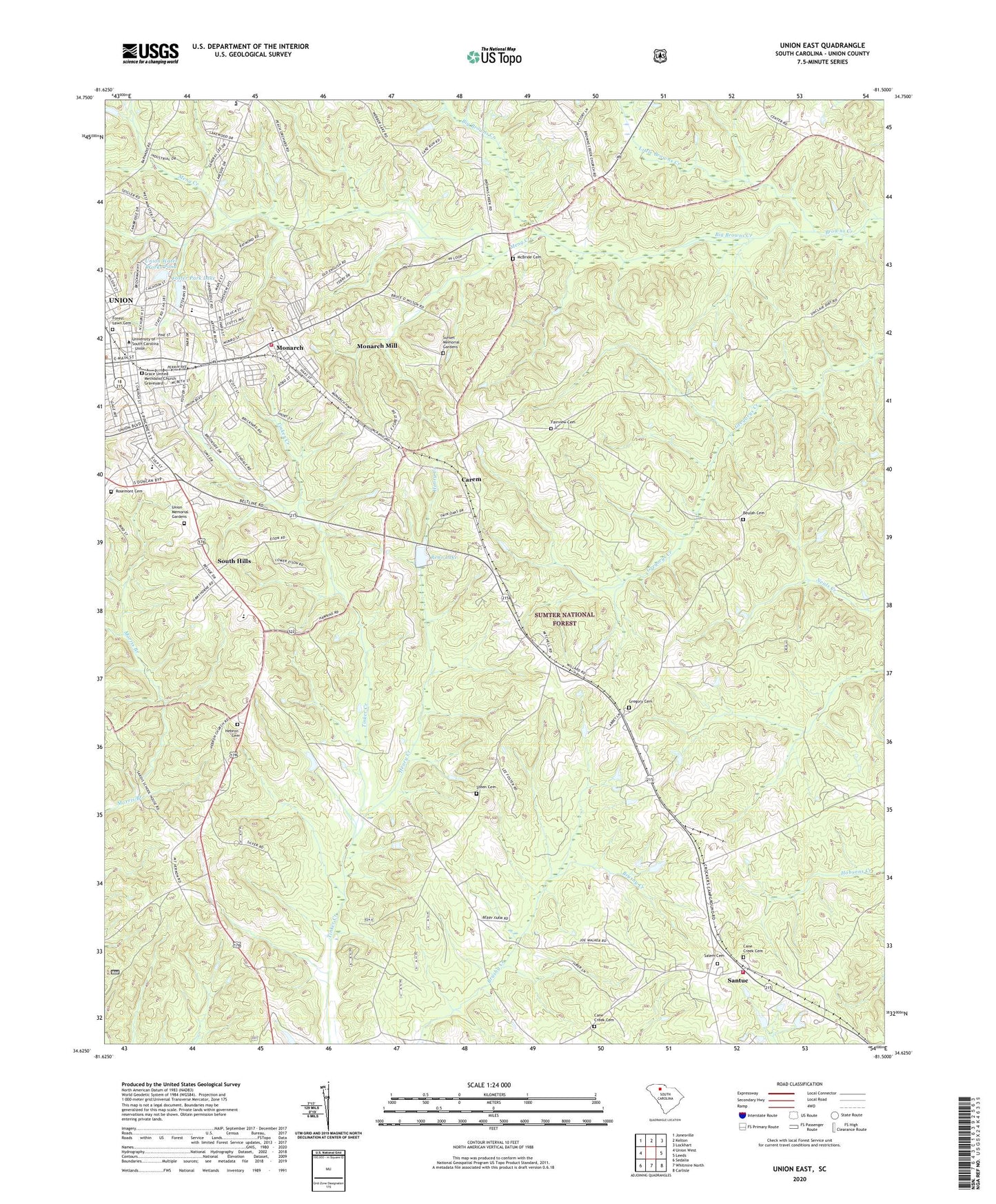
Union East South Carolina US Topo Map
Couldn't load pickup availability
Also explore the Union East Forest Service Topo of this same quad for updated USFS data
2024 topographic map quadrangle Union East in the state of South Carolina. Scale: 1:24000. Based on the newly updated USGS 7.5' US Topo map series, this map is in the following counties: Union. The map contains contour data, water features, and other items you are used to seeing on USGS maps, but also has updated roads and other features. This is the next generation of topographic maps. Printed on high-quality waterproof paper with UV fade-resistant inks.
Quads adjacent to this one:
West: Union West
Northwest: Jonesville
North: Kelton
Northeast: Lockhart
East: Leeds
Southeast: Carlisle
South: Whitmire North
Southwest: Sedalia
This map covers the same area as the classic USGS quad with code o34081f5.
Contains the following named places: Augsburg Evangelical Lutheran Church, Beattys Chapel, Bethel African Methodist Episcopal Church, Bethel United Methodist Church, Bethesda Church, Bethseda Church, Beulah Baptist Church, Beulah Cemetery, Big Browns Creek, Browns Creek Baptist Church, Cane Creek Cemetery, Cane Creek Presbyterian Church, Carem, Carem School, Central Junior High School, Church of Christ, Church of God, City of Union, Clifford Female Seminary, Cohen Street School, East Main Street-Douglass Heights Historic District, Episcopal Church of the Nativity, Excelsior Elementary School, Fairview Baptist Church, Fairview Cemetery, First Baptist Church of Union, First Presbyterian Church, Forest Lawn Cemetery, Foster Park Elementary School, Foster Park Lake, Foster Park Lake Dam D-2155, Grace United Methodist Church, Grace United Methodist Church Graveyard, Gregory, Gregory Cemetery, Hebron Baptist Church, Hebron Cemetery, Henry Creek, James Hope School, Little Browns Creek, Main Street Grammar School, Maple Ridge Baptist Church, Maple Ridge School, McBeth Grammar School, McBride Cemetery, McCutchen Memorial Presbyterian Church, Meador, Meng Creek, Mon Aetna Baptist Church, Monarch, Monarch Elementary School, Monarch Fire Department, Monarch Mill Census Designated Place, Morningside Baptist Church, Mount Vernon Church, New Chapel, New Hill, New Primary School, Oattaray School, Poplar Grove School, Reno Lake, Renumber Lake Dam D-2156, Rosemont Cemetery, Saint Augustine Catholic CHurch, Saint Paul Baptist Church, Salem Baptist Church, Salem Cemetery, Santuc, Santuc Fire Department, Santuck School, Sims High School, South Hills, Steen Cemetery, Sunset Memorial Gardens, Tabernacle Baptist Church, Thomas Chapel African Methodist Episcopal Church, Tinker Creek Church, Tinker Creek School, Tyger Work Center, Union, Union Academy, Union Carnegie Library, Union Church, Union County, Union County Emergency Medical Services, Union Division, Union Downtown Historic District, Union High School, Union Memorial Gardens, Union Plaza Shopping Center, Union Seventh Day Adventist Church, Union Water Works Pond, Union Water Works Pond Dam D-2154, Unionville Female Academy, Unionville Male Academy, Unity Methodist Church, University of South Carolina Regional Campus, Veterans Memorial park, ZIP Code: 29379