MyTopo
Rainy Mountain Georgia US Topo Map
Couldn't load pickup availability
Also explore the Rainy Mountain Forest Service Topo of this same quad for updated USFS data
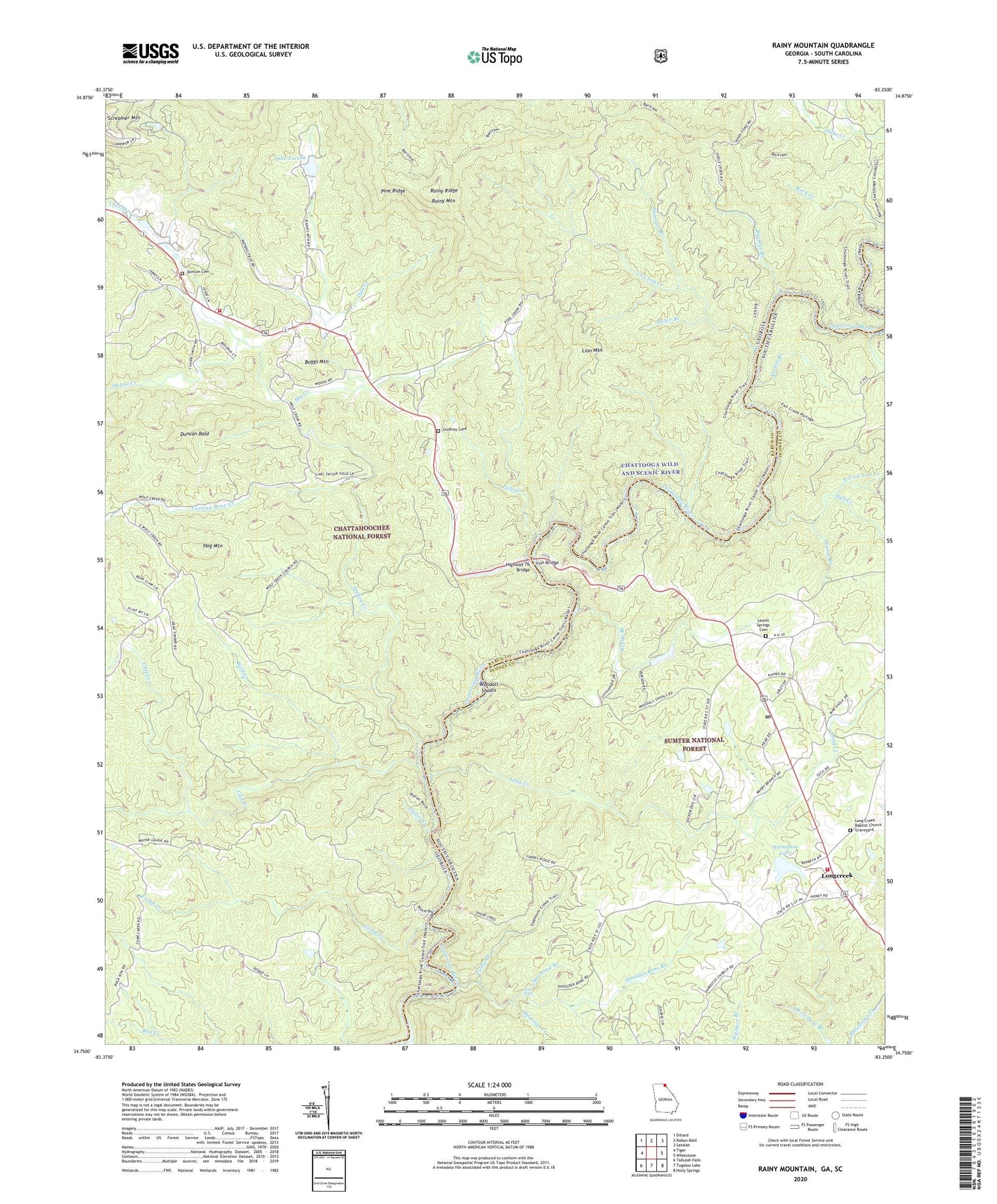
2024 topographic map quadrangle Rainy Mountain in the states of Georgia, South Carolina. Scale: 1:24000. Based on the newly updated USGS 7.5' US Topo map series, this map is in the following counties: Rabun, Oconee. The map contains contour data, water features, and other items you are used to seeing on USGS maps, but also has updated roads and other features. This is the next generation of topographic maps. Printed on high-quality waterproof paper with UV fade-resistant inks.
Quads adjacent to this one:
West: Tiger
Northwest: Dillard
North: Rabun Bald
Northeast: Satolah
East: Whetstone
Southeast: Holly Springs
Southwest: Tallulah Falls
Contains the following named places: Bartram Trail, Boggs Mountain, Brasstown School, Brysons Apple Orchard, Buckeye Branch, Camp Branch, Camp Creek, Camp Creek Church, Chattooga Belle Farm, Chattooga River Information Center, Chattooga Trail, Chechero Church, Chechero Creek, Chechero School, Chechero Volunteer Fire Station, Cliff Creek, Cutting Bone Creek, Daniel Creek, Dud Creek, Duncan Bald, Duncan Cemetery, Fall Creek, Fishtrap Branch, Godfrey Cemetery, Highway 76 Bridge, Hog Mountain, Horseshoe Lake, Horseshoe Lake Dam D-1650, Iron Bridge, Lake Toccoa, Lake Toccoa Dam, Laurel Spring Church, Laurel Springs Cemetery, Lick Log Creek, Lion Mountain, Long Creek, Long Creek Baptist Church Graveyard, Long Creek Post Office, Long Creek Volunteer Fire Department Oconee County Station 9, Long Mountain Church, Longcreek, Longcreek Census Designated Place, New Hope Church, North Fork Fall Creek, Opossum Creek, Persimmon Branch, Pinckney Branch, Pine Ridge, Pole Creek, Rainy Mountain, Rainy Mountain Camp, Rainy Ridge, Razor Branch, Reedy Branch, Rock Spring Branch, Rouges Ford, Round Mountain Apple Orchard, Sawhead Branch, She Creek, Shoulder Bone Branch, Sids Falls, Squirrel Branch, Stekoa Creek, Stump Branch, Tilly Branch, Turpin Branch, Wolf Creek, Wolf Creek Church, Woodall Shoals, Woodall Shoals Recreation Site, ZIP Code: 29658