MyTopo
Rapid City East South Dakota US Topo Map
Couldn't load pickup availability
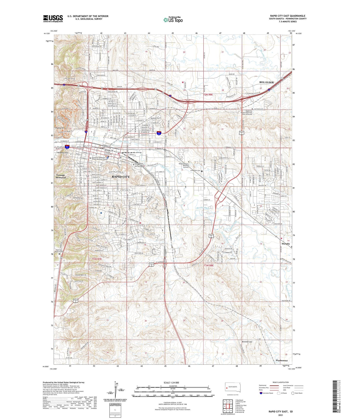
2021 topographic map quadrangle Rapid City East in the state of South Dakota. Scale: 1:24000. Based on the newly updated USGS 7.5' US Topo map series, this map is in the following counties: Pennington. The map contains contour data, water features, and other items you are used to seeing on USGS maps, but also has updated roads and other features. This is the next generation of topographic maps. Printed on high-quality waterproof paper with UV fade-resistant inks.
Quads adjacent to this one:
West: Rapid City West
Northwest: Blackhawk
North: Rapid City NW
Northeast: Bend
East: Box Elder
Southeast: Hermosa NE
South: Hermosa NW
Southwest: Rockerville
This map covers the same area as the classic USGS quad with code o44103a2.
Contains the following named places: Bergquist School, Berry Patch Campground, Black Hills Lutheran Middle School, Black Hills Maze, Black Hills Rehabilitation Hospital, Black Hills Surgery Center, Black Hills Visitor Information Center, Bump-Macdonald Paleontology Library, Calvary Christian Elementary School, Central High School, Chemistry/Chemical Engineering Building, City of Rapid City, Civil/Mechanical Engineering Building, College Park, Connolly Hall, Cowboy Hill, Cyclone Ditch, Dahl Fine Arts Center, Dakota Middle School, Devereaux Library, Dinosaur Park, Dunham Field, Electrical Engineering/Physics Building, Emmanuel Episcopal Church Memorial Garden, Evergreen Cemetery, Executive Golf Course, Garfield School, General Beadle Elementary School, Grandview Elementary School, Haines Station Shopping Center, Halley Park, Hangman Hill, Hawthorne Ditch, He Sapa College Center, He Sapa College Center Library, Howard Peterson Hall, Iowa Ditch, James E Martin Paleontology Research Laboratory, Jefferson Academy, Journey Museum, KIMM-AM (Rapid City), King Center, KKHJ-FM (Rapid City), KKLS-AM (Rapid City), Knollwood Heights Elementary School, KOTA-AM (Rapid City), KTEQ-FM (Rapid City), KTOQ-AM (Rapid City), KVSR-FM (Rapid City), LaCroix Links Golf Course, Lakota Homes, Lazy J RV Park and Campground, Lincoln School, Mann School, McLaury Building, Mineral Industries Building, Murphy, Museum of Geology, National American University - Rapid City, North Middle School, North Rapid Shopping Center, Northgate Shopping Center, O'Hara Building, O'Harra Stadium, Palmerton Hall, Pennington County Courthouse, Pennington County Jail, Pennington County Sheriff's Office, Pine Lawn Memorial Park, Pioneer Museum, Rapid City, Rapid City Fairgrounds, Rapid City Fire Department - Station 1, Rapid City Fire Department - Station 4, Rapid City Fire Department - Station 7, Rapid City Hall, Rapid City KOA, Rapid City Lutheran Elementary School, Rapid City Police Department, Rapid City Post Office, Rapid City Public Library, Rapid City Public Library North, Rapid City Regional Hospital, Rapid City Regional Hospital Heliport, Rapid City Visitor Information Center, Rapid Valley, Rapid Valley Elementary School, Rapid Valley Volunteer Fire Department, Robbinsdale Elementary School, Robbinsdale Park, Robbinsdale Shopping Center, Roosevelt Park, Roosevelt School, Rushmore Mall, Rushmore Plaza Civic Center, Saint Paul's Elementary School, Saint Thomas More High School, Same Day Surgery Center, Seton Elementary School, Seton Middle School, Seton Pre-Kindergarten School, Sioux Indian Museum, Sioux Village, South Dakota Highway Patrol District 3 - Headquarters, South Dakota School of Mines and Technology, South Dakota School of Mines and Technology Geology Museum, South Middle School, South Park Elementary School, South Town Mall, Surbeck Center, The Ranch Amusement Park, Thomas Jefferson Library, Township of Rapid, Twilight Hills Addition, Valley View Elementary School, Western Dakota Technical Institute, Wilson Park, Woodrow Wilson Elementary School