MyTopo
Sioux Falls East South Dakota US Topo Map
Couldn't load pickup availability
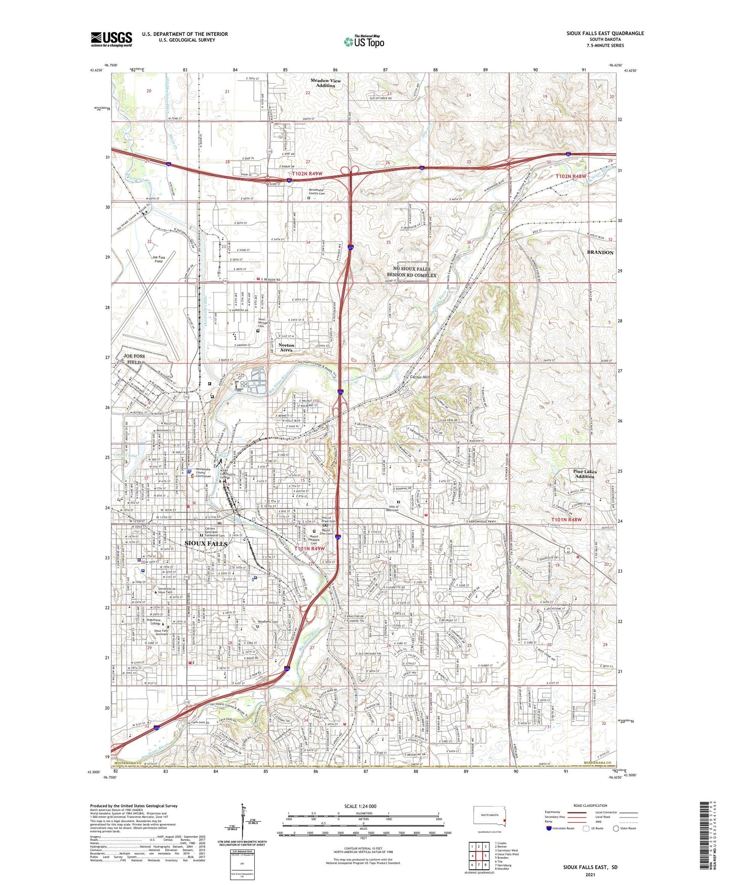
2021 topographic map quadrangle Sioux Falls East in the state of South Dakota. Scale: 1:24000. Based on the newly updated USGS 7.5' US Topo map series, this map is in the following counties: Minnehaha, Lincoln. The map contains contour data, water features, and other items you are used to seeing on USGS maps, but also has updated roads and other features. This is the next generation of topographic maps. Printed on high-quality waterproof paper with UV fade-resistant inks.
Quads adjacent to this one:
West: Sioux Falls West
Northwest: Crooks
North: Renner
Northeast: Garretson West
East: Brandon
Southeast: Klondike
South: Harrisburg
Southwest: Tea
This map covers the same area as the classic USGS quad with code o43096e6.
Contains the following named places: Administration Building, All Saints School, Anderson Subdivision, Anne Sullivan Elementary School, Archeology Laboratory, Augustana College, Avera McKennan Hospital, Axtell Park Middle School, Bancroft School, Beadle Park, Beadle School, Bergsaker Hall, Bishop Hare Statue, Bowden Softball Field, Bryant Park, Burgess Hall, Cactus Heights, Cactus Hills, Cactus Hills Country Club, Calvary Episcopal Cathedral Cemetery, Calvin School, Center for Visual Arts, Chapel of Reconciliation, Christ the King Elementary School, City of Sioux Falls, Cleveland Elementary School, Cleveland Professional Development Center, Collier Baker Hall, Costello Hall, Covells Lake, Diversion Canal, Dugan Park, East Hall, Eastside Plaza, Edison Middle School, Edith Mortenson Center, Elmen Center, Emerson School, Eugene Field Elementary School, Evergreen School, Falls Park, Fantle Building, First Convenant Church, Franklin School, Fred Assam Elementary School, Froelich Addition, Gilbert Science Center, Glidden Hall, Good Shepherd Elementary School, Grand Island Hall, Granksou Hall, Harriet L J Ronning Branch Library, Harvey Dunn Elementary School, Hawthorne Elementary School, Hill Ridge Development, Hills of Rest Cemetery, Hollister School, Holy Spirit Elementary School, Hope School, Horace Mann Elementary School, Huether Tennis Centre, Humanities Center, Ingberg Tracts, Irving School, Jefferson Elementary School, Jeschke Fine Arts Center, Joe Foss Alternative School, Joe Foss Field, John Harris Elementary School, Jorden Hall, KAUR-FM (Sioux Falls), KCFS-FM (Sioux Falls), Kilian Community College, Kirkeby-Over Stadium, KPAT-FM (Sioux Falls), Kresge Recital Hall, Kroske Hall, Ladders Park, Larson Track and Field Complex, Laura B Anderson Elementary School, Lien Park, Lincoln High School, Lincoln School, Linwood School, Longfellow Elementary School, Lowell Elementary School, Lyon Park, Madsen Social Science Center, Mark Twain Elementary School, McDonald Center, McKennan Park, Meadow View Addition, Meadow View Addition Census Designated Place, Meldrum Park, Messiah Church, Mikkelsen Library, Minnehaha County Cemetery, Minnehaha County Courthouse, Minnehaha County Poor Farm, Minnehaha County Sheriff's Office, Morrison Commons, Morstad Field, Mount Pleasant Cemetery, Mount Zion Cemetery, Nelson Service Center, Norman B Mears Library, Norse Inn Apartments, North Parkway, Norton Acres, Oak View Branch Library, Old Courthouse Museum, Old Main Building, Old Yankton Trail Stone Marker, Olson Park, Orpheum Theater, Our Saviors Lutheran Church, Patrick Henry Middle School, Patterson Hall, Pettigrew Home and Museum, Pettigrew Museum Library, Picasso Park, Pine Lakes Addition, Pine Lakes Addition Census Designated Place, Pioneers of Minnehaha County Monument, Riverdale Park, Robert Frost Elementary School, Ronken Baseball Field, Rosa Parks Elementary School, Saint Joseph School, Saint Lambert Elementary School, Saint Mary Elementary School, Saint Michael's Cemetery, Saint Therese School, Salsbury Science Center, Sanford Medical Center Intensive Air, Sanford University of South Dakota Medical Center, Schoeneman Apartments, Select Specialty Hospital, Silver Creek, Sioux Falls, Sioux Falls Arena, Sioux Falls Army Air Field, Sioux Falls City Hall, Sioux Falls Diversion Channel, Sioux Falls Diversion Dam and Weir, Sioux Falls Fire Rescue Station 1, Sioux Falls Fire Rescue Station 2, Sioux Falls Fire Rescue Station 3 Headquarters, Sioux Falls Fire Rescue Station 7, Sioux Falls Fire Rescue Station 9, Sioux Falls Fire Training Center, Sioux Falls Ice and Recreation Center, Sioux Falls Lutheran Elementary School, Sioux Falls Lutheran Pre-Kindergarten East School, Sioux Falls Main Library, Sioux Falls Police Law Enforcement Center, Sioux Falls Post Office, Sioux Falls Seminary, Sioux Falls Stadium, Sioux Falls Surgical Center, Sioux Valley Hospital, Slip-up Creek, Solberg Hall, Sons of Israel Cemetery, South Dakota Air National Guard 114th Fighter Wing, South Dakota State Penitentiary, South Dakota State Penitentiary Jameson Annex, South Sioux Falls, South Sioux Falls City Hall, South Sioux School, Split Rock Heights, Split Rock Township Volunteer Fire Department, Stavig Hall, Stewart Center, Sullivan Faith and Living Center, Terrace Park, Terry Redlin Elementary School, Township of Sioux Falls, Tuthill Park, Tuve Hall, University of Sioux Falls, Van Eps Park, Washington High School, Whipple School, Whittier Middle School, Willow Creek Shopping Plaza, Woodlawn Cemetery, ZIP Codes: 57103, 57104, 57105, 57110, 57197