MyTopo
Bearden Tennessee US Topo Map
Couldn't load pickup availability
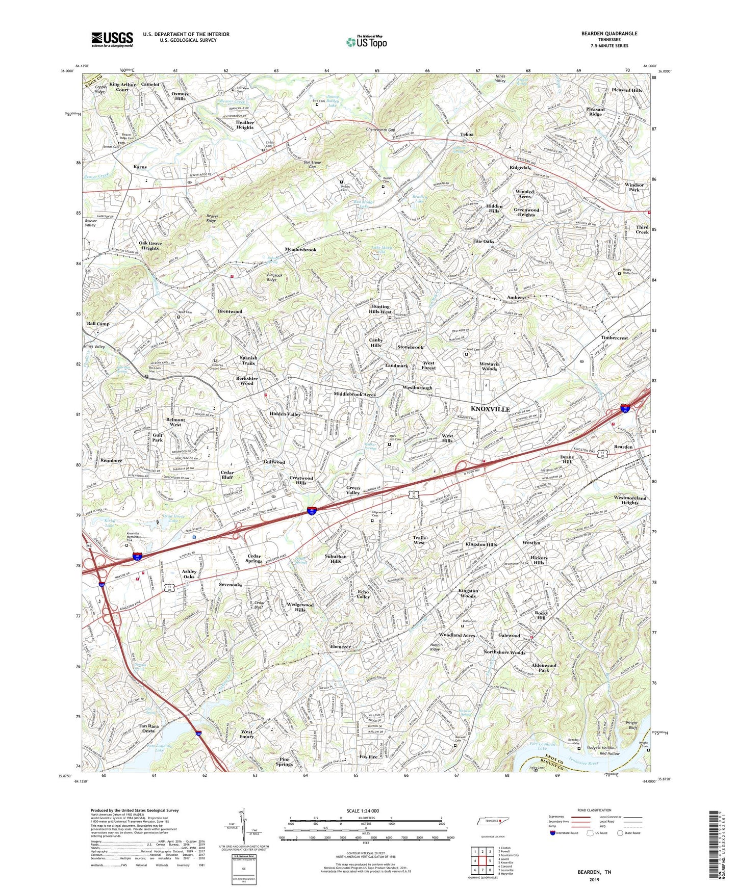
2019 topographic map quadrangle Bearden in the state of Tennessee. Scale: 1:24000. Based on the newly updated USGS 7.5' US Topo map series, this map is in the following counties: Knox, Blount, Anderson. The map contains contour data, water features, and other items you are used to seeing on USGS maps, but also has updated roads and other features. This is the next generation of topographic maps. Printed on high-quality waterproof paper with UV fade-resistant inks.
Quads adjacent to this one:
West: Lovell
Northwest: Clinton
North: Powell
Northeast: Fountain City
East: Knoxville
Southeast: Maryville
South: Louisville
Southwest: Concord
Contains the following named places: Aldenwood Park, Amherst, Amherst School, Appalachian Child Development Center, Arnstein Community Center, Ashley Oaks, Badgett Hollow, Ball Camp, Ball Camp Elementary School, Ball Camp Park, Ball Road Church, Bearden, Bearden Cemetery, Bearden High School, Bearden Junior High School, Bearden Shopping Centery, Beardens Creek, Beaver Ridge, Beeler Cemetery, Belmont West, Berkshire Wood, Bird Cemetery, Blackoak Ridge, Blue Grass Elementary School, Bonneville Estates, Bradley Lake, Brentwood, Brimer Cemetery, Bud Hodge Lake, Byington, Camelot, Campground Chapel, Canby Hills, Cedar Bluff, Cedar Bluff Church, Cedar Bluff Intermediate School, Cedar Bluff Middle School, Cedar Bluff Post Office, Cedar Bluff Primary School, Cedar Bluff Quarry, Cedar Bluff Schools, Cedar Bluff Shopping Center, Cedar Grove School, Cedar Springs, Cedar Springs Shopping Center, Chandler Lake, Cheneworth Gap, Childs Cemetery, Commissioner District 3, Commissioner District 4, Concord Trailer Park, Country Estates Mobile Home Park, Countryside, Cox View Cemetery, Crestwood Hills, Cumberland Estates, Cumberland Estates Shopping Center, Dead Horse Lake, Dead Horse Lake Golf Course, Deane Hill, Deane Hill Golf and Country Club, Duncan Spring, Dunn Cemetery, Dye Stone Gap, Eagles Landing Mobile Home Park, Ebenezer, Ebenezer Branch, Ebenezer Church, Echo Valley, Edgewood Cemetery, Edington, Eldridge Spring, Eubanks Chapel Cemetery, Everhard Mission Church, Fair Oaks, Faith Church, Farrington, Fox Fire, Fox Road Dock, Fox Spring, Galewood, Glen Arden, Golden Meadows, Good Samaritan Church, Grace Church, Green Valley, Greenwood Heights, Grove Hill Church, Gulf Park, Gulfwood, Happy Home Cemetery, Happy Home School, Heather Heights, Helen Ross McNabb Center, Hickory Hills, Hidden Hills, Hidden Valley, Holiday Hills, Holloway Cemetery, Hospital School, Hunting Hills West, Imperial Estates, Jimmy Baisley Lake, Jimmy Baisley Lake Dam, Johnson Spring, Jones Cemetery, Karns, Karns Census Designated Place, Karns Church, Karns Community Park, Karns Fire Department Station 1, Karns High School, Karns Intermediate School, Karns Middle School, Karns Mobile Home Kort, Karns Post Office, Karns Primary School, Karns Volunteer Fire Department Station 4, Kensington, King Arthur Court, Kingston Hills, Kingston Woods, Kinkaid, Kirby Lake, Knox County Prison Farm, Knoxville Boat Club Dock, Knoxville Fire Department John J Duncan Station 21, Knoxville Fire Department Northwest Station 17, Knoxville Fire Department Station 18, Knoxville Fire Department Station 20, Knoxville Memorial Park, Knoxville Post Office, Lake Mary Ella, Lakeview Church, Landmark, Lillian A Pedigo School, Little Creek Airpark, Mars Hill Cemetery, Mars Hill Church, Maxwell Cemetery, Maxwell Spring, Meadowbrook, Methodist Cemetery, Middlebrook Acres, Middlebrook Industrial Park, Middlebrook Pike Church, Middlebrook Pike United Methodist Church, Montvue, Montvue Shopping Center, Montwood Church, New Covenant Church, Northshore Church, Northshore Woods, Northwest General Hospital, Nubbin Ridge, Oak Grove Heights, Oehler Springs, Oxmore Hills, Parkwest Medical Center, Phibbs Cemetery, Pine Springs, Piney Grove Church, Piney Grove Mobile Home Park, Pleasant Hills, Pleasant Ridge, Pleasant Ridge Elementary School, Red Hollow, Reed Cemetery, Rennbore, Ridgedale, Ridgedale Community Park, Ridgedale Elementary School, Roberts Spring, Rocky Hill, Rocky Hill Elementary School, Rocky Hill Park, Rocky Hill Shopping Center, Rothwood, Rural - Metro Fire Department Station 10, Rural - Metro Fire Department Station 17, Rural - Metro Fire Department Station15, Sacred Heart Church and School, Saint Marks United Methodist Church, Scenic View Farm, Schaad Spring, Sevenoaks, Shannondale Homes, Spanish Trails, Statesview, Stonebrook, Suburban Hills, Suburban Shopping Center, Tan Rara Airport, Tan Rara oesta, Tates School, Tekoa, Tekoa Church, Ten Mile, Ten Mile Creek, Tennessee Highway Patrol District One Headquarters, Third Creek, Timbercrest, Trails End, Trails West, Valley Grove Church, Van Loon Cemetery, Walker Springs, Walker Springs Plaza Shopping Center, Webb School, Wedgewood Hills, West Emory, West End Academy, West Forest, West Hills, West Hills Elementary School, West Hills Park, West Knoxville Mobile Park, West Side YMCA, West Town Mall, Westavia Woods, Westborough, Westlyn, Westmoreland Heights, Willowbrook Mill, Windsor Park, Wooded Acres, Woodland Acres, Wright Bluff, Wright Cemetery, Wrights Ferry Church, Zion Childrens Home, ZIP Codes: 37909, 37919, 37921, 37923