MyTopo
Louisville Tennessee US Topo Map
Couldn't load pickup availability
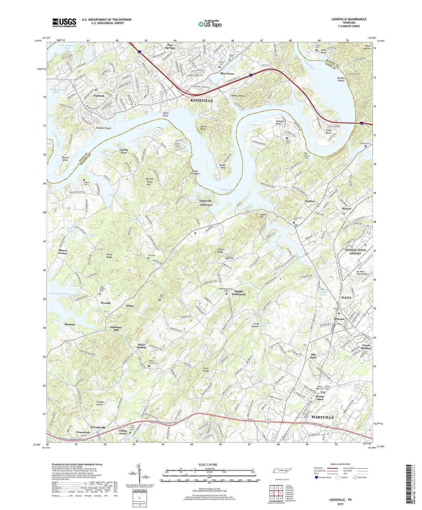
2022 topographic map quadrangle Louisville in the state of Tennessee. Scale: 1:24000. Based on the newly updated USGS 7.5' US Topo map series, this map is in the following counties: Blount, Knox. The map contains contour data, water features, and other items you are used to seeing on USGS maps, but also has updated roads and other features. This is the next generation of topographic maps. Printed on high-quality waterproof paper with UV fade-resistant inks.
Quads adjacent to this one:
West: Concord
Northwest: Lovell
North: Bearden
Northeast: Knoxville
East: Maryville
Southeast: Blockhouse
South: Binfield
Southwest: Meadow
This map covers the same area as the classic USGS quad with code o35084g1.
Contains the following named places: 134th CES / CEF Tennessee Air National Guard, 37737, 37777, 37922, Admiral Farragut Park, Arline, Armona, Armona Baptist Church, Armona Cemetery, Armona School, Bear Hollow, Beech Grove Church, Bent Tree, Blount County Fire Protection District Station 6, Blount County Industrial Park, Blue Grass, Blue Grass Dock, Bond Quarry, Brown Quarry, Byerly Cemetery, Cactus Cove, Caney Branch, Carl Cowan Park, Carlton, Castaway Cove, City of Louisville, Commissioner District 10, Commissioner District 2, Cox Cemetery, Cox Creek, Craig Cemetery, Craig Quarry, Davis Cemetery, Dug Gap, East Emory Church, East Emory School, Emanuel Church, Evans Quarry, Ewing, Farmington, Fort Loudoun Yacht Club Dock, Friendsville Division, Funk Quarry, Garland, Garland School, George Cemetery, George Creek, Gillespies Landing, Gooseneck, Grace Cemetery, Grace Church, Green Meadow, Grey Ridge, Henrys Ferry, Henson Island, Hillview Church, Hitch Pond, Holston Cemetery, Holston College, Holston Cumberland Presbyterian Church, Hunter Valley Farm, Immanuel Church, Interdenominational Holiness Association Campground, Jackson Bend, Jenkins Ridge, Jones Bend, Jones Bend Blount County Park, Jones Cemetery, Jones Chapel, Keller Bend, Keller Bend Park, Keller Bluff, Kellys Fort, Kidds Schoolhouse, Lackey Creek, Lakeview, Lakewood, Laurel Bank Branch, Lewis Cemetery, Light Pink Church, Light Pink Quarry, Little Creek Sanitarium, Logan Hill, Long Hollow, Louisville, Louisville Cemetery, Louisville Church, Louisville Dock, Louisville Junior High School, Louisville Point Park, Louisville Post Office, Lovingwood Spring, Lowe Ferry, Mahoney Mill, Marmor, Mentor, Mentor Community Park, Mentor Post Office, Mentor School, Middle Settlement, Middle Settlement Community Center, Middle Settlement Elementary School, Middle Settlement School, Middlesettlements Cemetery, Middlesettlements Methodist Church, Midway Church, Miser School, Miser Station, Moralfa, Mount Tabor, Mount Tabor Cemetery, Mount Tabor Presbyterian Church, Mount Vernon, Mount Vernon School, Mount Zion Church, Mountain Hill, Neeley Hollow, Old Glory, Peninsula Hospital, Peninsular Estates, Poland Creek, Poland Creek Recreation Area, Post Oak Island, Proffitt Spring, Pumpkin Center, Reed Quarry, Rocky Hill, Rural - Metro Fire Department Station 16, Russell Bend, Russells Cemetery, Russells Shoals, Saint Marks Church, Sapple Ferry, Seven Springs, Shady Grove Cemetery, Shady Grove Church, Sheep Pen Bluff, Sinking Creek, Smoky View Estates, Stone Field, Stony Point, Taylor Branch, Thompson Chapel, Tomb Ridge, Toole Bend, Union Grove, Union Grove Cemetery, Vertiflite Airport, Weatherspoon Island, Wells Fort, Wrights Shoals, Zions Chapel Baptist Church, Zions Chapel Cemetery