MyTopo
Crawford Tennessee US Topo Map
Couldn't load pickup availability
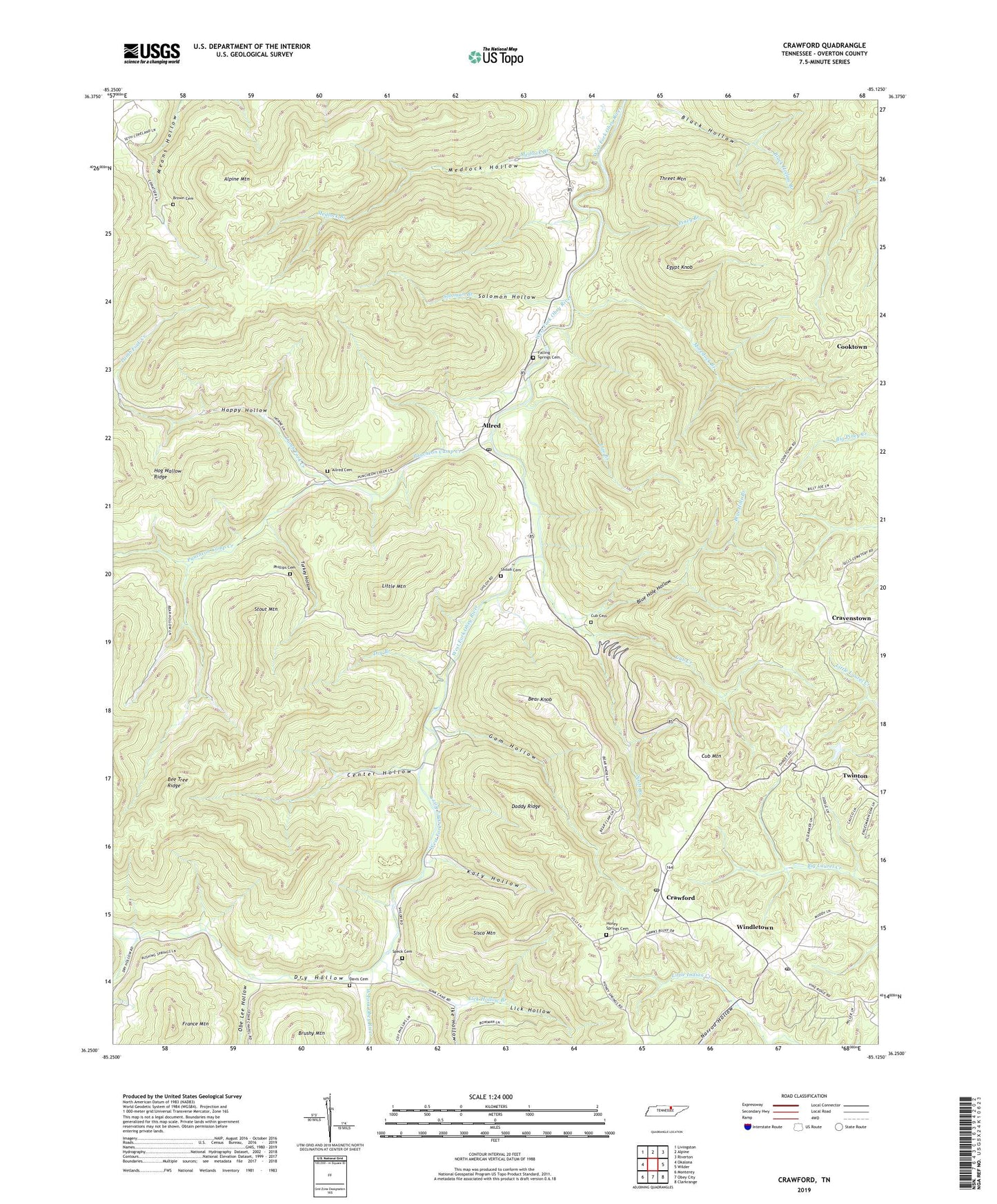
2022 topographic map quadrangle Crawford in the state of Tennessee. Scale: 1:24000. Based on the newly updated USGS 7.5' US Topo map series, this map is in the following counties: Overton. The map contains contour data, water features, and other items you are used to seeing on USGS maps, but also has updated roads and other features. This is the next generation of topographic maps. Printed on high-quality waterproof paper with UV fade-resistant inks.
Quads adjacent to this one:
West: Okalona
Northwest: Livingston
North: Alpine
Northeast: Riverton
East: Wilder
Southeast: Clarkrange
South: Obey City
Southwest: Monterey
This map covers the same area as the classic USGS quad with code o36085c2.
Contains the following named places: Allred, Allred Cemetery, Allred Post Office, Alpine Mountain, Bear Knob, Bee Tree Ridge, Blue Hole Branch, Blue Hole Hollow, Brown Cemetery, Center Hollow, Commissioner District 3, Cravenstown, Cravenstown School, Crawford, Crawford Grade School, Crawford Post Office, Crawford School, Cub Cemetery, Cub Creek, Cub Mountain, Daddy Ridge, Davis Cemetery, Dry Branch, Dry Hollow, Egypt Knob, Falling Springs Cemetery, Falling Springs Church, Gam Hollow, Happy Hollow, Hickory Flat School, Hog Wallow Ridge, Honey Springs Cemetery, Ike Hollow, Katy Hollow, Lamb Fork Creek, LBJ & C Headstart Center, Lick Hollow, Lick Hollow Branch, Little Mountain, Lize Branch, Medlock Branch, Medlock Hollow, Moredock Branch, Norrod Hollow, Obe Lee Hollow, Phillips Cemetery, Pines, Piney Branch, Poteet, Puncheon Camp Creek, Qualls, Scott Branch, Shiloh, Shiloh Cemetery, Shiloh School, Sisco Mountain, Soloman Branch, Solomon Hollow, Speck Cemetery, Stout Mountain, Three Forks Church, Threet Mountain, Tin Top School, Turkey Hollow, Twinton, Twinton School, Windletown, ZIP Codes: 38542, 38543