MyTopo
Dale Hollow Dam Tennessee US Topo Map
Couldn't load pickup availability
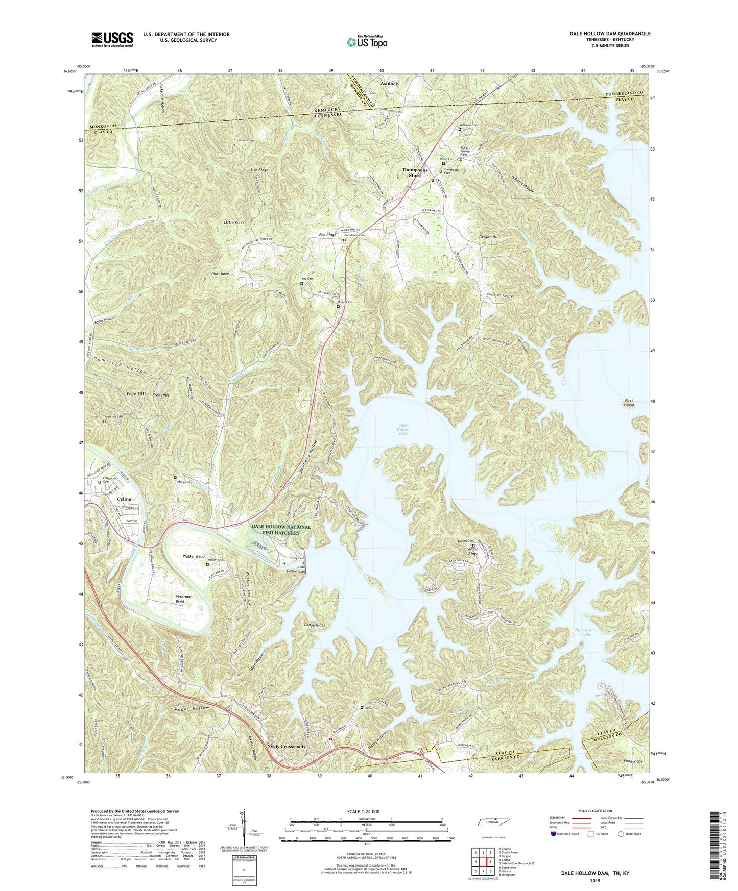
2022 topographic map quadrangle Dale Hollow Dam in the states of Tennessee, Kentucky. Scale: 1:24000. Based on the newly updated USGS 7.5' US Topo map series, this map is in the following counties: Clay, Monroe, Cumberland, Overton. The map contains contour data, water features, and other items you are used to seeing on USGS maps, but also has updated roads and other features. This is the next generation of topographic maps. Printed on high-quality waterproof paper with UV fade-resistant inks.
Quads adjacent to this one:
West: Celina
Northwest: Vernon
North: Blacks Ferry
Northeast: Frogue
East: Dale Hollow Reservoir SE
Southeast: Livingston
South: Hilham
Southwest: Burristown
This map covers the same area as the classic USGS quad with code o36085e4.
Contains the following named places: Ashlock, Barksdale Bend, Barksdale Hollow, Barksdales Ferry, Boone Hollow, Bowe Cemetery, Buford Cemetery, Bufords Store, Canoe Ridge, Carter Creek, Cave Springs, Cave Springs Church, Cave Springs School, Cedar Hill Boat Dock, Commissioner District 3, Commissioner District 4, Commissioner District 5, Cordell Hull Reservoir, Craig Cemetery, Crossroads Cemetery, Dale Bend, Dale Hollow, Dale Hollow Boat Dock, Dale Hollow Dam, Dale Hollow Dam Recreation Area, Dale Hollow Lake, Dale Hollow National Fish Hatchery, Dewberry Hollow, Donaldson Cemetery, Dry Branch, East 52 Volunteer Fire Department, East Fork Lick Run, First Island, Fitzgerald Cemetery, Fox Springs, Fox Springs School, Free Hill, Free Hill Cemetery, Free Hills, Free Hills Church of Christ, Free Hills Community Center, Free Hills School, Galton Hollow, Gap Branch, Goodpasture Bend, Grogan Hill, Hamilton Hollow, Holly Creek, Holly Creek Boat Dock, Holly Creek School, Hongkong School, Horse Creek, Horse Creek Boat Dock, Indian Creek, Jennings Hollow, Johnson Hollow, Keen Cemetery, Keene Bend, Keislings Store, Key Cemetery, Kyle Branch, Lick Run, Little Knob, Livingston Boat Dock, Long Branch, Martins Branch, Mitchell Creek, Mitchell Creek School, Modoc Bottom, Natty Branch, Neely Creek, Neely Crossroads, Neely Crossroads Church of Christ, Neelys Cross Roads School, New Salem Church, Pea Ridge, Pea Ridge Volunteer Fire Department, Peterman Bend, Pilot Knob, Pine Branch Church, Pine Branch School, Plainview School, Pleasant Grove Church of Christ, Pleasant Grove Recreation Area, Pleasant Grove School, Pond Ridge, Poor Branch, Riley Kerr Branch, Roberts Hollow, Rock Springs Cemetery, Rock Springs Church, Sewell Bend, Shanky Branch, Shanky Branch Church of God, Smith Creek, Standing Stone Dam, Standing Stone Lake, Star Ridge, Swann Ridge, Talley Hollow, Thompson - Webb Cemetery, Thompson Cemetery, Thompsons Store, Tinsley Branch, Tinsley Cemetery, Walker Bend, Walker Cemetery, Walker Hollow, Williams Cemetery, ZIP Code: 38551