MyTopo
Dutch Valley Tennessee US Topo Map
Couldn't load pickup availability
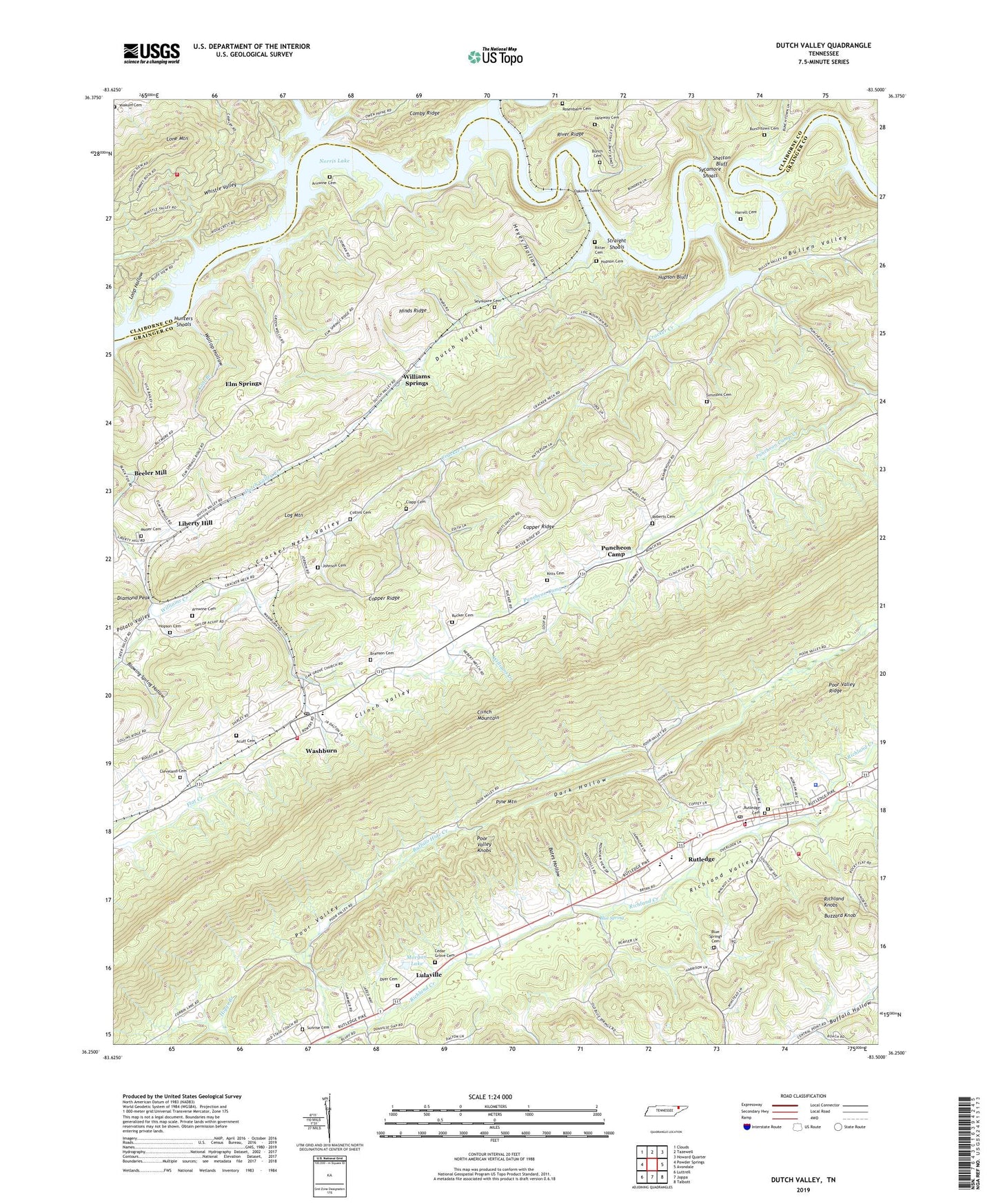
2022 topographic map quadrangle Dutch Valley in the state of Tennessee. Scale: 1:24000. Based on the newly updated USGS 7.5' US Topo map series, this map is in the following counties: Grainger, Claiborne. The map contains contour data, water features, and other items you are used to seeing on USGS maps, but also has updated roads and other features. This is the next generation of topographic maps. Printed on high-quality waterproof paper with UV fade-resistant inks.
Quads adjacent to this one:
West: Powder Springs
Northwest: Clouds
North: Tazewell
Northeast: Howard Quarter
East: Avondale
Southeast: Talbott
South: Joppa
Southwest: Luttrell
This map covers the same area as the classic USGS quad with code o36083c5.
Contains the following named places: Acuff Cemetery, Arnwine Cemetery, Arwine Ford, Ball Creek, Bates Hollow, Beeler Chapel, Beeler Mill, Blaine Division, Blowing Spring Hollow, Blue Spring, Blue Spring Church, Blue Springs Cemetery, Branson Cemetery, Bridgeport Church, Buffalo Hide Creek, Bullen Valley, Bunch Cemetery, Bunches Trace, Bunchtown Cemetery, Buzzard Knob, Cedar Grove Cemetery, Cedar Grove Church, Center View School, Clapp Cemetery, Clear Springs, Cleveland Cemetery, Clinch River, Coffman Camp, Collins Cemetery, Commissioner District 4, Cool Branch, Corbin Dam, Corbin Lake, Cracker Creek, Cracker Neck Valley, Dark Hollow, Diamond Peak, Dotson Creek, Dutch, Dutch Valley, Dutch Valley Church, Dutch Valley Creek, Dutch Valley School, Dyer Cemetery, Eadie Ford, Edderson Branch, Ellis Bridge, Elm Springs, Elm Springs School, Elm Springs United Baptist Church of Jesus Christ, Grainger County, Grainger County Rescue Squad, Grainger County Sheriff's Department, Harrell Cemetery, Henry Crossing, Heyes Hollow, Hopson Bluff, Hopson Cemetery, Hunters Shoals, Janeway Cemetery, Johnson Cemetery, Kitts Cemetery, Liberty Hill, Liberty Hill School, Locust Grove Church, Lone Mountain Creek, Loop Hollow, Lulaville, Morgan Lake, Morgan Lake Dam, Moyer Cemetery, Noe Chapel, Oak Grove Baptist Church, Oakman, Oakman Tunnel, Pine Mountain, Puncheon Camp, Puncheon Camp Baptist Church, Puncheon Camp Creek, Puncheon Camp School, Richland Knobs, Ritter Cemetery, Roberts Cemetery, Rosenbalm Cemetery, Rucker Cemetery, Rutledge, Rutledge Cemetery, Rutledge Elementary School, Rutledge High School, Rutledge Methodist Church, Rutledge Middle School, Rutledge Post Office, Rutledge Presbyterian Church, Rutledge Recreational Park, Rutledge Volunteer Fire Department, Salem Church, Seymoure Cemetery, Shelton Bluff, Sheltons Ford, Shirley Crossing, Simmons Cemetery, South Claiborne Volunteer Fire Department Station 43, Straight Shoals, Sunrise Cemetery, Sunrise Church, Sunset, Sycamore Island, Sycamore Shoals, Town of Rutledge, Wallop Hollow, Washburn, Washburn Baptist Church, Washburn Division, Washburn Post Office, Washburn School, Washburn Volunteer Fire Department, Whistle Valley, Williams Springs, Yoakum Cemetery, ZIP Code: 37888