MyTopo
La Vergne Tennessee US Topo Map
Couldn't load pickup availability
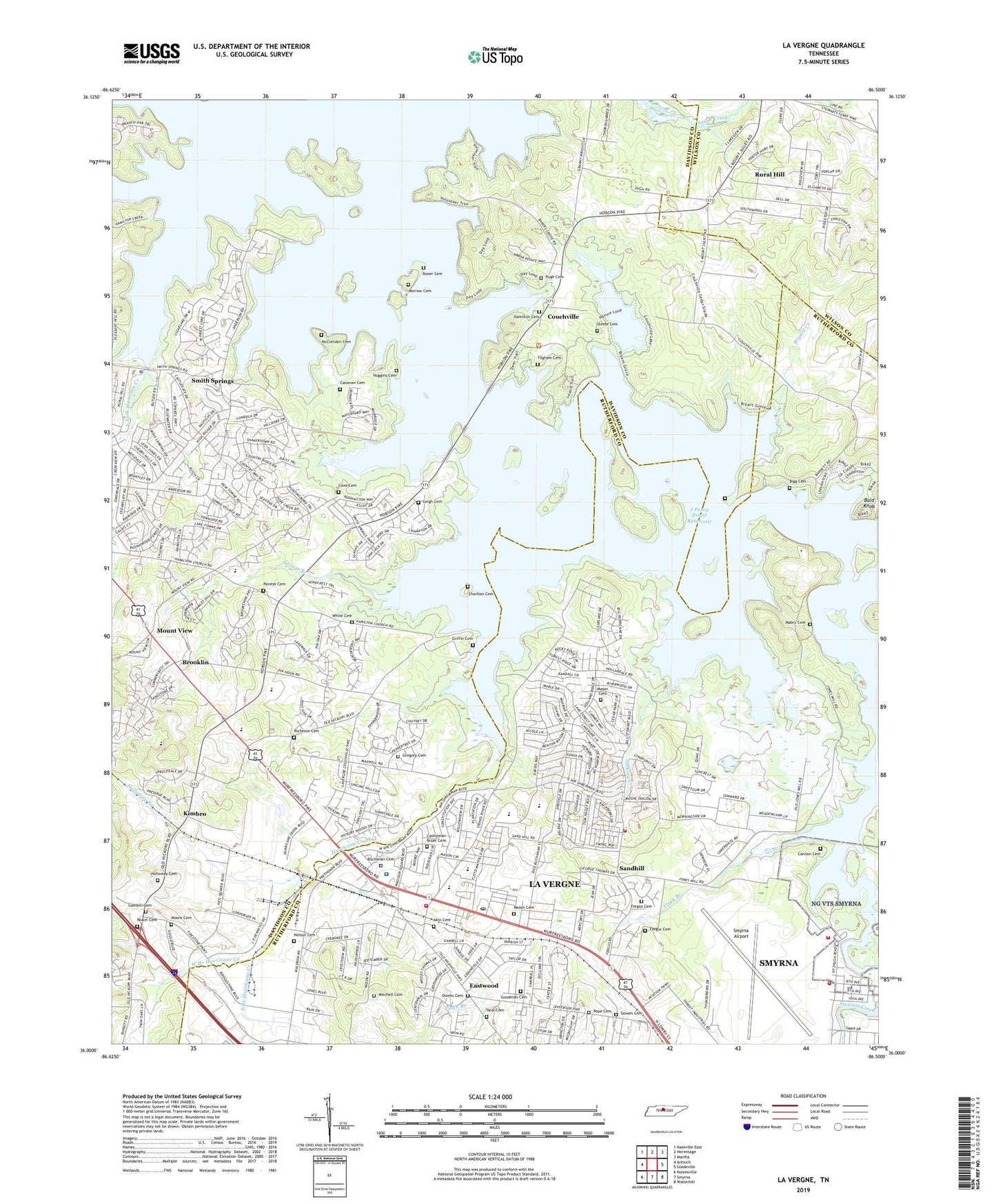
2022 topographic map quadrangle La Vergne in the state of Tennessee. Scale: 1:24000. Based on the newly updated USGS 7.5' US Topo map series, this map is in the following counties: Davidson, Rutherford, Wilson. The map contains contour data, water features, and other items you are used to seeing on USGS maps, but also has updated roads and other features. This is the next generation of topographic maps. Printed on high-quality waterproof paper with UV fade-resistant inks.
Quads adjacent to this one:
West: Antioch
Northwest: Nashville East
North: Hermitage
Northeast: Martha
East: Gladeville
Southeast: Walterhill
South: Smyrna
Southwest: Nolensville
This map covers the same area as the classic USGS quad with code o36086a5.
Contains the following named places: Akin Cemetery, Anderson Road Public Use Area, Arnold Cemetery, Bald Knob, Bannister Mine, Bethel Church, Bigg Cemetery, Boner Cemetery, Brooklin, Bryant Creek, Bryant Grove Church, Buchanan Cemetery, Buchanans Mill, Burnett Cemetery, Burnette Chapel, Cannon Cemetery, Cassman Cemetery, Castlegate Estates, Castleman - Bruer Cemetery, Castleman Cemetery, Charletons Mill, Charlton Cemetery, Cherry Hills, City of La Vergne, Commissioner District 1, Commissioner District 12, Commissioner District 33, Commissioner District 5, Cone Cemetery, Corinth Church, Couchville, Dobson Cemetery, Duncan Lake, East Branch Hurricane Creek, East Fork Hamilton Creek, Eastwood, Edge-O-Lake Estates, Ellis Cemetery, Eskridge Cemetery, Fergus Cemetery, Finch Branch, First Baptist Church, First Call Ambulance Service, Foster Corners, Four Corners, Four Corners Recreation Area, Four Corners School, Gambill Cemetery, Gambill Forrester Cemetery, Gilroy Church, Goodman Cemetery, Gowen Cemetery, Gowens Mission, Gregory Cemetery, Griffin Cemetery, Hall Chapel, Hamilton Cemetery, Hamilton Creek, Hamilton Creek Metropolitan Park, Hollandale School, Holloway Branch, Holloway Cemetery, Huggins Cemetery, Hurricane Creek, Hurricane Creek Recreation Area, J F Kennedy Middle School, J Percy Priest Reservoir, Jefferson Pike, Jefferson Pike Church, Jones Mill, Jones Mill Public Use Area, Kimbro, La Vergne, La Vergne City Hall, La Vergne Elementary School, La Vergne Fire Department Station 1 Headquarters, La Vergne Fire Department Station 43, La Vergne Middle School, La Vergne Post Office, La Vergne Primary School, LaVergne Police Department, Lavergne Rescue Unit Number 1, Leigh Cemetery, Long Hunter State Park, Long Island Beach, Lovell Church, Mabry Cemetery, Mann Cemetery, Mason Cemetery, McClendon Cemetery, Miller Cemetery, Mitchell Cemetery, Morningside Acres, Morrow, Morrow Cemetery, Morrow-Headden School, Mount View, Mount View Church, Mount View School, Neal Cemetery, Neil Bend, Nelson Cemetery, Owens Cemetery, Painter Cemetery, Perry Cemetery, Perrys Ford, Philippi Church, Pointed Side Acres, Ponderosa, Poole Knobs Recreation Area, Pope Cemetery, Priest Lake Park, Priest Lake Presbyterian Church, Pugh Cemetery, Rescue Squad: La Vergne Rescue Unit, Richeson Cemetery, Roach Cemetery, Rock Springs Elementary School, Roy Waldron Junior High School, Rural Hill Census Designated Place, Sandhill, Savage Branch, Scruggs Chapel, Scruggs Chapel School, Sebring Cemetery, Sewart Air Force Base, Sinking Creek, Slave Cemetery, Smith Springs, Smith Springs Church of Christ, Smith Springs Creek, Smith Springs Public Use Area, Smyrna Airport, Smyrna Airport Department of Public Safety, Smyrna Church, Smyrna Fire Department Station 2, Smyrna Golf Course, Solomon Chapel, Steele Cemetery, Stewart Creek Public Use Area, Suggs Creek, Thomas A Edison Elementary School, Tilgham Cemetery, Union School, West Branch Hurricane Creek, West Fork Hamilton Creek, White Cemetery, Willow Beach, ZIP Code: 37086