MyTopo
Lebanon Tennessee US Topo Map
Couldn't load pickup availability
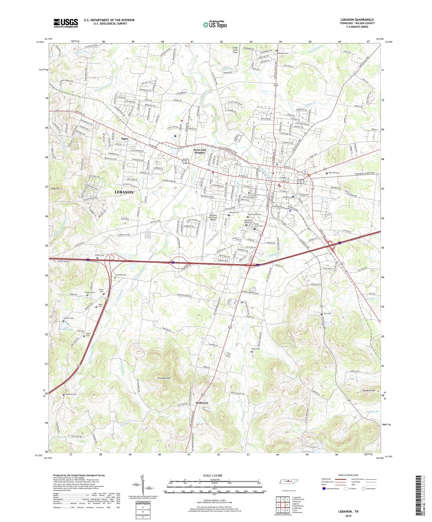
2022 topographic map quadrangle Lebanon in the state of Tennessee. Scale: 1:24000. Based on the newly updated USGS 7.5' US Topo map series, this map is in the following counties: Wilson. The map contains contour data, water features, and other items you are used to seeing on USGS maps, but also has updated roads and other features. This is the next generation of topographic maps. Printed on high-quality waterproof paper with UV fade-resistant inks.
Quads adjacent to this one:
West: Martha
Northwest: Laguardo
North: Hunters Point
Northeast: Bellwood
East: Shop Springs
Southeast: Watertown
South: Vine
Southwest: Gladeville
This map covers the same area as the classic USGS quad with code o36086b3.
Contains the following named places: Baird Municipal Park, Bartons Creek Church, Bethlehem Church, Byers Dowdy Elementary School, Campbell Academy, Camper Cemetery, Castle Heights Military Academy, Cedar Crest Field, Cedar Grove Cemetery, Chapman Cemetery, City of Lebanon, College Street Church of Christ, Commissioner District 17, Commissioner District 19, Commissioner District 20, Commissioner District 21, Commissioner District 24, Cumberland University, Eddins Cemetery, Egan, Fairview Baptist Church, First Baptist Church, Fite Cemetery, Flat Rock, Flat Rock Baptist Church, Flat Rock School, Floyd Cemetery, Forktown, Fourmile Hill, Greenwood Cemetery, Hankins Hill, Hebron Church, Herron Church, Herron School, Hickory Ridge Church of Christ, Highland Heights Elementary School, Holloway, Horn Springs, Hudson Cemetery, Hunters Point Golf Course, James E Ward Agricultural and Community Center, Johnson Cemetery, Laine Cemetery, Lebanon, Lebanon Country Club, Lebanon Division, Lebanon Female Institute, Lebanon Fire Department Station 1, Lebanon Fire Department Station 2, Lebanon High School, Lebanon Municipal Airport, Lebanon Police Department, Lebanon Post Office, Leemans Corner School, Ligon Cemetery, Maple Hill, Maple Hill Church, Maple Hill Seminary, Market Street Church of Christ, Market Street School, McCarmel Branch, McClean School, McFarland Hospital, Memorial Park Cemetery, Mount Olive Church, Mount Zion Baptist Church, Pennville, Professional Medical Transportation Wilson County, Putnam Lake, Putnam Lake Dam, Reed Cemetery, Rest Hill Cemetery, Rocky Valley Church, Rowland Cemetery, Sam Houston Elementary School, Seay Hill, Seay School, Seays Church, Second Baptist Church, Sinking Creek, Southside Annex Post Office, Southside Elementary School, Tarver Branch, Tennova Healthcare - Lebanon, Tennova Rehab Center at McFarland, Union Church, Van Hook Cemetery, Walter J Baird Middle School, WCOR-AM (Lebanon), West End Heights, West Fork Bartons Creek, WFMQ-FM (Lebanon), Wilson County, Wilson County Courthouse, Wilson County Farm, Wilson County Sheriff's Office, Wilson County Training School, Wilson County Vocational Center, Wilson Emergency Management Agency Station 1 Lebanon, Winters Chapel African Methodist Episcopal Church, WQDQ-AM (Lebanon)