MyTopo
Belvidere Tennessee US Topo Map
Couldn't load pickup availability
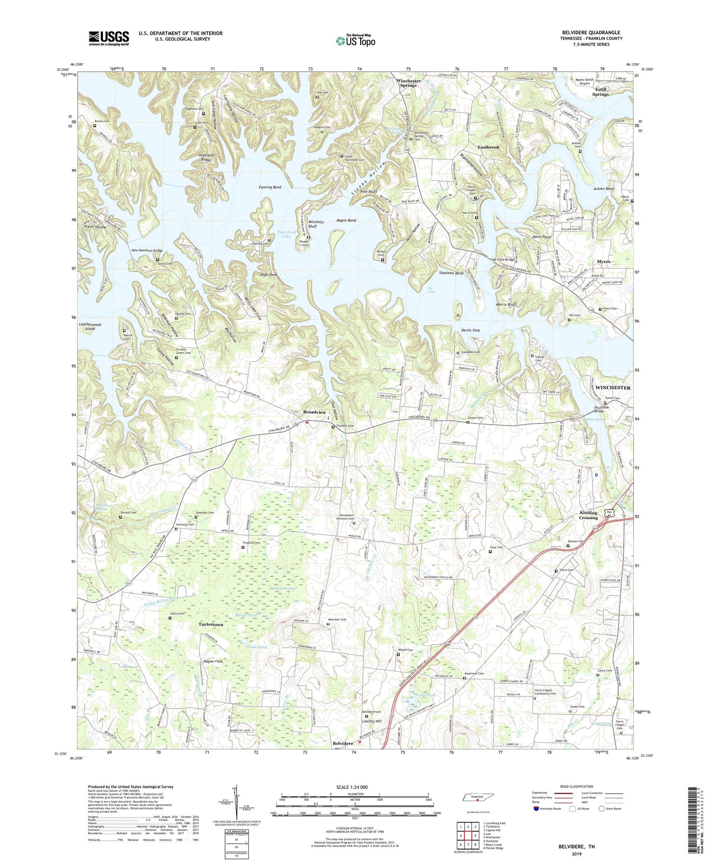
2022 topographic map quadrangle Belvidere in the state of Tennessee. Scale: 1:24000. Based on the newly updated USGS 7.5' US Topo map series, this map is in the following counties: Franklin. The map contains contour data, water features, and other items you are used to seeing on USGS maps, but also has updated roads and other features. This is the next generation of topographic maps. Printed on high-quality waterproof paper with UV fade-resistant inks.
Quads adjacent to this one:
West: Lois
Northwest: Lynchburg East
North: Tullahoma
Northeast: Capitol Hill
East: Winchester
Southeast: Pitcher Ridge
South: Beans Creek
Southwest: Huntland
This map covers the same area as the classic USGS quad with code o35086b2.
Contains the following named places: Acklen Bend, Acklen Cemetery, Anderson Branch, Ash Camp Hollow, Bear Branch, Belvidere, Belvidere Cemetery, Belvidere Census Designated Place, Belvidere Community Center, Belvidere Post Office, Belvidere Rural Volunteer Fire Department, Belvidere School, Belvidere United Church of Christ, Bethel United Methodist Church, Big Eddy, Big Hollow, Blackwood Hollow, Boiling Fork Creek, Broadview, Broadview Church, Broadview Elementary School, Broadview Volunteer Fire Department, Brown Cemetery, Burning Bush Church, Camp Elklore, Campbell Cemetery, Caney Hollow, Carson Cemetery, Carter Branch, Carvers Branch, Coles Branch, Commissioner District 1, Cook Cemetery, Coutta Cemetery, Cross Roads Baptist Church, Davis Point, Denson Cemetery, Devils Step, Donaldson-Simmons Cemetery, Dry Creek, Dry Creek Bridge, Dry Creek Estates, Eastbrook, Eastbrook Ford, Eastbrook Hollow, Elklore Cabin Site, Fairview School, Fairview/Devils Step Campground, Fanning Bend, Fanning Cemetery, Farris Cemetery, Farris Chapel, Farris Chapel Cemetery, Farris Chapel Community Cemetery, Farris Chapel United Methodist Church, Farris Spring, Finch Cemetery, Franklin Cemetery, Franklin County Sheriff's Office, Friendship Church, Glaus Pond, Graves Branch, Gray Cemetery, Green Cemetery, Harmony Division, Harris Cemetery, Harris Chapel, Harris Chapel Cemetery, Hessey Branch, High View, Highland Cemetery, Highland Ridge, Highland Ridge CAbin Site, Hill Cemetery Two, Hintons Mill, Holts Hollow, Hudgins Cemetery, Hurricane Creek, Johns Cemetery, Jones Ford, Kaserman Cemetery, Kaserman Switch, Kissling Crossing, Kitchen Hollow, Kitchens Cemetery, Kitchens Creek, Lance Cemetery, Leatherwood Cabin Site, Leatherwood Island, Lee Ford Bridge, Lee Spring, Lee Spring Hollow, Lees Ford, Liechty Hill, Little Hurricane Church, Little Hurricane Church Cemetery, Little Hurricane Creek, Little Hurricane School, Lockmiller Bridge, Long Branch, Long Pond, Loop Cabin Site, Macon Cemetery, Manns Ford, Mansford, Maple Bend, Matthew Branch, Miescher Cemetery, Mingo Pond, Mingo School, Mingo Swamp, Mitchells Bluff, Morris Bluff, Mount Carmel Church, Mount Zion, Mount Zion School, Murray Lake, Murray Lake Estates, Myers, Myers-Smith Airport, New Mansford Bridge, Oak Grove School, Old Mansford Bridge, Owl Hollow, Owl Hollow Bridge, Owl Hollow Church, Owl Hollow Creek, Owl Hollow Mill, Owl Hollow School, Pauper Cemetery, Phillips Cemetery, Pine Bluff, Pine Bluff Cabin Site, Poe Cemetery, Push Creek, Red Mill Bridge, Riva Lake Camp, Riva Lake Church, Robinson Hollow, Rocky Branch, Scivally-Green Cemetery, Shadow Spring, Shasteen Bend, Shasteen Cemetery, Shasteens Mill, Simmons Cemetery, Simmons Mill, Sleepy Hollow, Tarrant Cemetery, Taylortown, The Loop, Tims Ford Lake, Tims Ford State Rustic Park, Travis Hollow, Turner Cemetery, Union Hill School, Wagner Field, Water Cure Springs, Willis Lake Bridge, Willis Lake Cove, Winchester City Park, Winchester Springs, Winchester Springs Branch, Winchester Springs Cemetery, Winchester Springs School, Woods Cemetery, Young Cemetery, ZIP Code: 37398