MyTopo
Maryville Tennessee US Topo Map
Couldn't load pickup availability
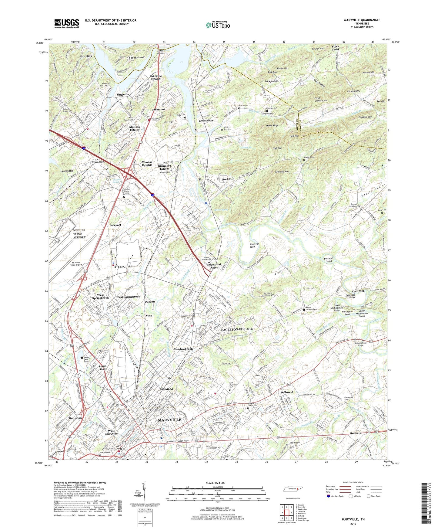
2019 topographic map quadrangle Maryville in the state of Tennessee. Scale: 1:24000. Based on the newly updated USGS 7.5' US Topo map series, this map is in the following counties: Blount, Knox. The map contains contour data, water features, and other items you are used to seeing on USGS maps, but also has updated roads and other features. This is the next generation of topographic maps. Printed on high-quality waterproof paper with UV fade-resistant inks.
Quads adjacent to this one:
West: Louisville
Northwest: Bearden
North: Knoxville
Northeast: Shooks Gap
East: Wildwood
Southeast: Kinzel Springs
South: Blockhouse
Southwest: Binfield
Contains the following named places: Airport Plaza, Alcoa, Alcoa Elementary School, Alcoa Fire Department Station 1, Alcoa Fire Department Station 2, Alcoa Fire Department Station 3, Alcoa High School, Alcoa Little League Park, Alcoa Municipal Building, Alcoa Police Department, Alcoa Post Office, Amerene, Amerine Park, Asbury Acres, Asbury Estates, Ballards Chapel Cemetery, Bank, Bassel Addition, Bassel School, Beech Grove Church, Beechwood, Belmont Addition, Benford Heights Addition, Bicentennial Park, Bittle Heights, Blount Beach, Blount County Access Area, Blount County Courthouse, Blount County Fire Protection District Station 2, Blount County Fire Protection District Station 6, Blount County Health Department, Blount County Library, Blount County Sheriff's Office, Blount Memorial Hospital, Brabson Ford Bridge, Brakebill Island, Brickyard Mountain, Broadway Tower, Brown Creek, Brown School, Bungalow, Bungalow Elementary School, Caney Branch, Casteel Branch, Cates Bridge, Cave Mill, Cedar Cliffs, Cedar Lawn Cemetery, Centennial Cemetery, Central Park, Central Point Cemetery, Chandler, Chandler Spring, Charles Hall School - Isabela, Cherokee Park, Church Hill, City of Alcoa, City of Rockford, Clarks Grove Cemetery, Commissioner District 1, Commissioner District 3, Commissioner District 9, Culton Creek, Dellwood, Doctors Hospital, Duncan, Duncan Branch, Duncan Creek, Dunlap Branch, Eagleton Elementary School, Eagleton Middle School, Eagleton Village, Eagleton Village Census Designated Place, East Maryville Cemetery, East Springbrook, Edgewood Acres, Edington Cemetery, Eggers Addition, Everett Football Field, Everett Heights, Everett High School, Everett Park, Farrport, Flag Branch, Ford Addition, Fort Craig Elementary School, Fort Craig Hospital, Fox Hills, Friends Cemetery, Gillespys Fort, Glenmore Estates, Goddard Mountain, Godddard Field, Grandview Cemetery, Grandview Heights, Gravelly Creek, Gravelly Mountain, Green Meadow Country Club, Gunn Hollow, Hall Mountain, Hall Park, Hannum Addition, Harris Cemetery, Harth Addition, High Top, Hillsdale, Hollybrook Branch, Horseshoe Bend, Hubbard, Hubbard Elementary School, Hunt Field, Iris Acres, Jackson Hills, John Sevier Elementary School, John Sevier Park, Johnson Mountain, Kirby Cemetery, Kit Carson School, Knoxville Council Girl Scout Camp, Lakemont, Lakeview Estates, Langley Hollow, Little River, Littlebrook, Littlebrook Industrial Park, Lower McCammon Island, Magnolia Cemetery, Maryville, Maryville City Hall, Maryville College, Maryville Fire Department, Maryville Fire Department Station 2, Maryville Police Department, Maryville Post Office, Maryville Sewage Treatment Plant, Maryville-Alcoa Division, Maxie Ridge, Mc Ghee Tyson Airport, McCullocks Fort, McTeer Spring, Meadowbrook, Meadowood, Metro-Aire Industrial Park, Midland Shopping Center, Mimosa Estates, Mimosa Heights, Mount Lebanon Cemetery, Mount Moriah Cemetery, Mount Zion Cemetery, Mountain Trace, Murphy Commerical Park, Nails Creek, New Lincoln School, New Providence Cemetery, Notime, Oakhurst, Old Mount Lebanon Cemetery, Oldfield Addition, Oldfield Park, Peach Orchard Mountain, Peppermint Branch, Peppermint Hills, Pine Lakes Golf and Country Club, Pistol Creek, Plainfield, Plainfield addition, Pleasant Grove Cemetery, Polecat Branch, Rambo Mountain, Red Hill, Rivertrace, Rock Garden Park, Rockford, Rockford Community Park, Rockford Elementary School, Rockford Police Department, Rockford Post Office, Rockford Station, Rockgardens, Rocky Waters, Roddy Branch, Rule Gap, Rural / Metro Ambulance Blount County, Russell Branch, Russell Cemetery, Sam Houston School, Scenic Terrace, Self Hollow, Sevier Heights, Sherwood Memorial Gardens, Singleton, Singleton Bend, Singleton Terminal, Slave Cemetery, South Hall, Springbrook, Springbrook Elementary School, Springbrook Park, Springfield, Springfield Branch, Stock Creek, Stock Creek Marina, Summit Hills, Tara Estates, Tarkiln Valley, Taylor Cemetery, Tedford Branch, Thomas Fort, Tipton Station, Trinity Church, Twelve Oaks, Twin Oak Estates, Union Elementary School, Union Planters Building, University of Tennessee Animal Science Field Laboratory, Upper McCammon Island, Veach-May-Wilson Industrial Park, Vineyard Cemetery, Volunteer Yacht Basin, Vose, W J Hale School, Washington School, WEAG-AM (Alcoa), Wesley Ann Cemetery, West Maryville, West Side School, West Springbrook, Westfields, WGAP-AM (Maryville), Wilders Chapel Cemetery, Wildwood Bridge, Woodmont Addition, ZIP Codes: 37701, 37804, 37853