MyTopo
Shady Valley Tennessee US Topo Map
Couldn't load pickup availability
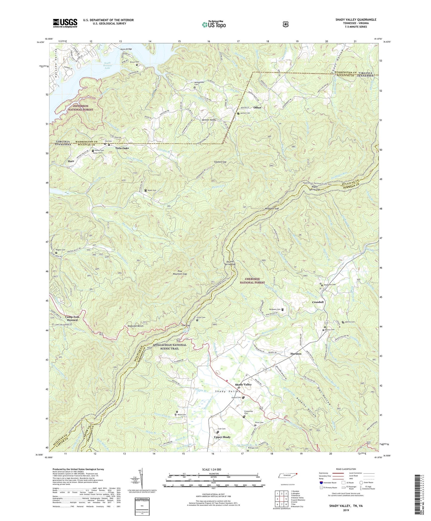
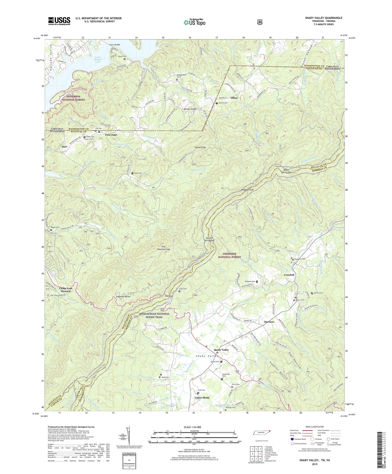
2019 topographic map quadrangle Shady Valley in the states of Tennessee, Virginia. Scale: 1:24000. Based on the newly updated USGS 7.5' US Topo map series, this map is in the following counties: Sullivan, Johnson, Washington, Carter. The map contains contour data, water features, and other items you are used to seeing on USGS maps, but also has updated roads and other features. This is the next generation of topographic maps. Printed on high-quality waterproof paper with UV fade-resistant inks.
Quads adjacent to this one:
West: Holston Valley
Northwest: Wyndale
North: Abingdon
Northeast: Damascus
East: Laurel Bloomery
Southeast: Mountain City
South: Doe
Southwest: Carter
Contains the following named places: Abingdon Gap Appalachian Trail Shelter, Arnold Branch, Avens Bridge, Avens Island, Bear Wallow Trail, Bee Suck Branch, Bentley Mine, Birch Branch, Blevins Cemetery, Brickyard Branch, Brinkley Branch, Brown Cemetery, Buck Ridge, Buck Ridge Branch, Camp Tom Howard, Camp Tom Howard Dam, Camp Tom Howard Lake, Central Church, Civilian Conservation Corps Camp Shelby, Cole Cemetery, Cole Prospect, Commissioner District 6, Cox Cemetery, Cox Mill Creek, Crandull, Crandull School, Cress Prospect, Cross Mountain, Crosswhite Cemetery, David Blevins Branch, Davis Mine, Delaney Mountain, Denton Cemetery, Denton School, Denton Valley, Denton Valley Church, Denton Valley School, Dogwood Bench, Double Spring Gap, Double Spring Shelter, Dry Run, Dyestone Branch, East Fork Beaverdam Creek, Falls Mill, Flat Spring Branch, Garland Prospect, Gentry Branch, Gentry Cemetery, Grable Branch, Graveyard Ridge, Green Mountain Branch, Grindstone Branch, Grindstone Knob, Ham Greer Mine, Harmon, Harp Mountain, Harpers Creek, Harr, Heaberlin Branch, Heaberlin Cemetery, Hignite Branch, Hotter Cemetery, Jacob, Jacobs Creek Job Corps, Jim Wright Branch, Jinkerson Branch, Johnson Blevins Branch, Keller Island, Kettlefoot Wildlife Management Area, King Mine, Lewis Ridge, Lipford Prospect, Little Mountain, Little Pine Mountain, Locust Knob, Locust Knob Branch, Locust Pole Knob, Low Gap, Low Gap Branch, Low Gap Spring, Maple Spring Fire Trail, Maple Spring Gap, Marriage Ground Ridge, Marshall Branch, Maxwell Mine, McQueen Branch, McQueen Branch Prospect, McQueen Cemetery, McQueen Gap, McQueen Knob, Middle Fork Beaverdam Creek, Milam Branch, Montgomery Cemetery, Neil Mine, New School, Offset, Offset School, Old Road Branch, Owl Branch, Owl Hollow, Parks Branch, Phillipps Cemetery, Pine Mountain, Pine Mountain Gap, Pleasantview Church, Potter Cemetery, Price Cemetery, Reece School, Rich Knob, River Bluff Church, Robbins Hollow, Robbins Hollow Prospect, Rock Church, Rogers Cemetery, Rush School, Rutter Branch, Rutter Ridge, Ryefield Ridge, Scott Branch, Scott Cemetery, Scott Prospect, Shady Valley, Shady Valley Church, Shady Valley Elementary School, Shady Valley Post Office, Shady Valley School, Shady Valley Volunteer Fire Department, Snake Spur, South Chapel, Sowbed Gap, Swanagan Mountain, Thomas Branch, Thorn Prospect, Twin Oaks, Upper Shady, Walker Mine, Wallace Prospect, Watson Branch, Wheeler Spur, Winchester, Winchester School, Wolf Creek, Wolf Creek Boat Dock, Wood Cemetery, Wright Mine, Wyatt Cemetery, Wyatt Fire Trail, Wyatt School, ZIP Code: 37688