MyTopo
Shelbyville Tennessee US Topo Map
Couldn't load pickup availability
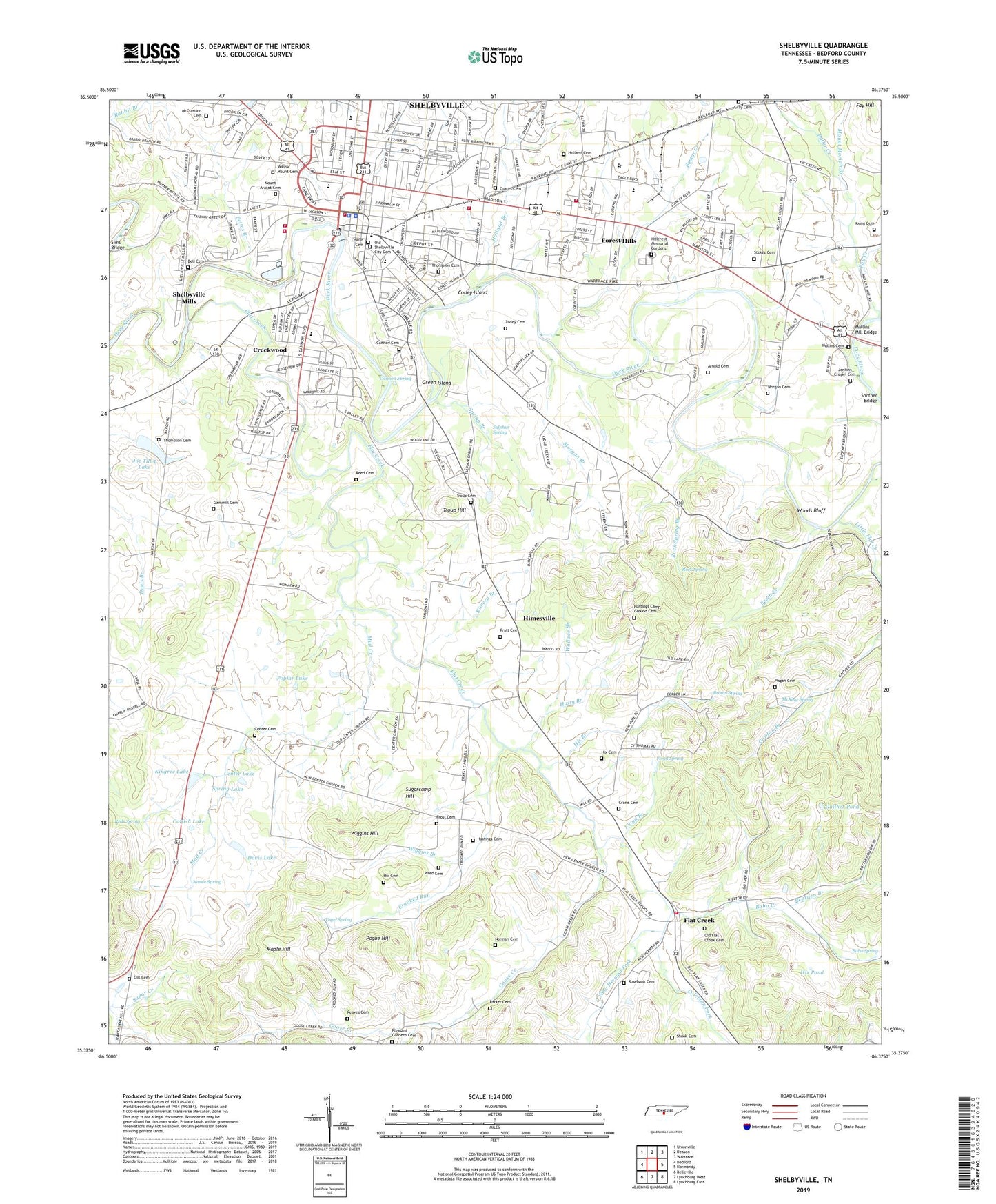
2022 topographic map quadrangle Shelbyville in the state of Tennessee. Scale: 1:24000. Based on the newly updated USGS 7.5' US Topo map series, this map is in the following counties: Bedford. The map contains contour data, water features, and other items you are used to seeing on USGS maps, but also has updated roads and other features. This is the next generation of topographic maps. Printed on high-quality waterproof paper with UV fade-resistant inks.
Quads adjacent to this one:
West: Bedford
Northwest: Unionville
North: Deason
Northeast: Wartrace
East: Normandy
Southeast: Lynchburg East
South: Lynchburg West
Southwest: Belleville
This map covers the same area as the classic USGS quad with code o35086d4.
Contains the following named places: Arnold Cemetery, Bearden Branch, Bedford County Courthouse, Bedford County Fire and Rescue, Bedford County Hospital, Bedford County Jail, Bedford County Sheriff's Department, Bedford-Moore Vocational Center, Beech Creek, Bell Cemetery, Bethany Baptist Church, Bible Presbyterian Church, Big Springs Shopping Center, Bobo Creek, Bobo Spring, Bomar Creek, Brown Spring, Butler Creek, Butler Creek School, Calvary Baptist Church, Cannon Baptist Church, Cannon Cemetery, Cannon Spring, Cannon United Methodist Church, Catfish Lake, Center Cemetery, Center Church, Center Lake, Central High School, City of Shelbyville, Clearview Horse Farm, Coates Cemetery, Coleman Fork, Commissioner District 5, Commissioner District 6, Commissioner District 7, Commissioner District 9, Coney Island, Cow Ford, Cowan Cemetery, Crane Cemetery, Creekwood, Crooked Run, Cross Roads School, Davis Lake, Davis Lake Dam, East Shelbyville Historic District, East Side Elementary School, Edgemon Baptist Church, Episcopal Church of the Redeemer, Faith Baptist Church, Fay Creek, Fay Hill, First Assembly of God Church, First Christian Church, First Church of the Nazarene, First Presbyterian Church, First United Methodist Church, Flat Creek, Flat Creek Mill, Flat Creek School, Floyd Branch, Floyd Spring, Forest Hills, Frost Cemetery, Gaither Pond, Gammill Cemetery, Gill Cemetery, Goose Creek, Gray Cemetery, Grays Crossing, Green Island, Hammonds Mill, Harris Middle School, Hastings Camp Ground Cemetery, Hastings Cemetery, Hasty Branch, Hillcrest Memorial Gardens, Himesville, Himesville Church, Hix Branch, Hix Cemetery, Hix Mill Ford, Hix Pond, Holland Branch, Holland Cemetery, Holly Grove School, Holts Mill, Jenkins Chapel, Jenkins Chapel Cemetery, Joe Tillet Dam, Joe Tillet Lake, Kimery Branch, Kingree Lake, Kizer Ford, Little Flat Creek, Locust Grove School, Maple Hill, Mc Cuistion Cemetery, McKing Spring, Moore Ford, Morgan Branch, Morgan Cemetery, Mount Ararat Cemetery, Mount Moriah Branch, Mount Zion Church, Mount Zion School, Mud Creek, Mullins Cemetery, Mullins Chapel, Mullins Chapel African Methodist Episcopal Church, Mullins Chapel School, Mullins Mill, Mullins Mill Bridge, Nance Spring, New Hermon Fork, New Hope Church, Norman Cemetery, Old Flat Creek Cemetery, Old Shelbyville City Cemetery, Parker Cemetery, Pettus Branch, Pisgah Cemetery, Pisgah Church, Pleasant Gardens Cemetery, Pogue Hill, Poplar Lake, Pratt Cemetery, Reaves Cemetery, Reds Spring, Reed Cemetery, River Bend Estates Golf and Country Club, Rock Spring, Rock Spring Branch, Rosebank Cemetery, Saint Marks Church, Saint Marks School, Saint Williams Catholic Church, Sanford Fire Brigade Station 2 Shelbyville Manufacturing Center, Sanford Fire Brigade Station 4 Liquid Manufacturing Technical Center, Scullcamps Bridge, Shamrock Farms, Shelbourne Farms, Shelbyville, Shelbyville Church of God, Shelbyville Courthouse Square Historic District, Shelbyville Dam, Shelbyville Division, Shelbyville Fire Department Station 1, Shelbyville Fire Department Station 2, Shelbyville First Baptist Church, Shelbyville Hydroelectric Station, Shelbyville Mills, Shelbyville Mills Baptist Church, Shelbyville Mills Church of Christ, Shelbyville Mills School, Shelbyville Police Department, Shelbyville Post Office, Shook Cemetery, Sims Bridge, Skull Camp Ford, Southside Baptist Church, Southside Church, Southside School, Spring Branch, Spring Lake, Stokes Cemetery, Sugarcamp Hill, Sulphur Spring, Sulphur Spring Branch, Tennessee Walking Horse National Showgrounds, Thomas Elementary School, Thompson Cemetery, Troup Cemetery, Troup Hill, Vogel Spring, Volunteer Fire Services Station 5 / Flat Creek Volunteer Fire Department, Wallace Branch, Walnut Valley Farms, Waterfall Farms, West End United Methodist Church, WHAL-AM (Shelbyville), Wiggins Branch, Wiggins Hill, Willow Mount Cemetery, Wiser Farm, WLIJ-AM (Shelbyville), Woodfork African Methodist Episcopal Church, Woods Bluff, Word Cemetery, Young Cemetery, Zivley Cemetery, ZIP Code: 37160