MyTopo
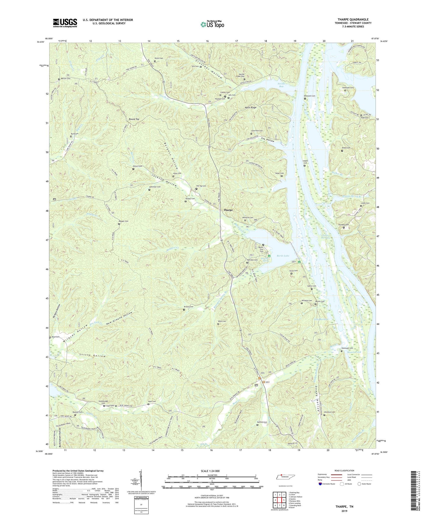
Tharpe Tennessee US Topo Map
Couldn't load pickup availability
Also explore the Tharpe Forest Service Topo of this same quad for updated USFS data
2022 topographic map quadrangle Tharpe in the state of Tennessee. Scale: 1:24000. Based on the newly updated USGS 7.5' US Topo map series, this map is in the following counties: Stewart. The map contains contour data, water features, and other items you are used to seeing on USGS maps, but also has updated roads and other features. This is the next generation of topographic maps. Printed on high-quality waterproof paper with UV fade-resistant inks.
Quads adjacent to this one:
West: Hamlin
Northwest: Rushing Bay
North: Linton
Northeast: Johnson Hollow
East: Bumpus Mills
Southeast: Dover
South: Standing Rock
Southwest: Paris Landing
This map covers the same area as the classic USGS quad with code o36087e8.
Contains the following named places: Andersons Landing, Bards Creek, Bards Dam, Bards Lake, Barrett Creek, Barrow Cemetery, Bear Creek, Bear Creek Waterfowl Management Unit, Bee Branch, Beech Fork Creek, Blue Creek, Boswell Cemetery, Boyd Cemetery, Brandon Cemetery, Brandon Spring, Brandon Spring Branch, Brandon Spring Group Camp, Brandons Landing, Brown Cemetery, Bruton Cemetery, Bruton Spring Branch, Buckingham Hollow, Bufford Cemetery, Bumpus Mills Recreation Area, Burgess Hollow, Byrd Cemetery, Cathey Cemetery, Commissioner District 4, Cow Creek, Crutcher Hollow, Dennis Cemetery, Dry Branch, Dunlap Cemetery, Elliots Landing, Fox Hollow, Gatlin Cemetery, Gatlin Point Lake Access, Happy Hollow, Happy Hollow Branch, Harris Branch, Herndon Cemetery, Hickory Grove Church, Hickory Hollow, Hicks Cemetery, Hicks Landing, Hill Top Cemetery, Hopewell Church, Horton Chapel, Houston Cemetery, Jackson Hollow, Jackson Landing, Keel Cemetery, Knott Cemetery, Legate Cemetery, Lone Pine Cemetery, Luton Cemetery, Mannings Landing, Miles Cemetery, Model Division, Morgan Cemetery, Mount Zion Cemetery, Neville Bay, Neville Bay Lake Access, Neville Creek, Neville Creek Cemetery, Neville Creek Church, New Ground Hollow, Nolan Cemetery, Nolin Ridge, Nolins Landing, Oak Grove Church, Pea Ridge School, Pettit Cemetery, Popular Springs School, Rawles Landing, Rawls Pond, Rayburn Creek, Ross Cemetery, Round Top, Saline Creek Access Point, Saline Creek Public Use Area, Scarborough Cemetery, Shammels Mound Landing, Shemwell Cemetery, Sills Cemetery, Snider, South Fork Panther Creek, Stalls Cemetery, Stewarts Landing, Stilly Hollow, Stone Cemetery, Tharpe, Tharpe Church, Tharpe School, Tip Top, Tiptop Church, Walker Branch, Walkers Landing, Whitford Cemetery, Wildcat Hollow, Wilkinson Cemetery, Williams Cemetery, Williams Landing