
MyTopo
Unionville Tennessee US Topo Map
Couldn't load pickup availability
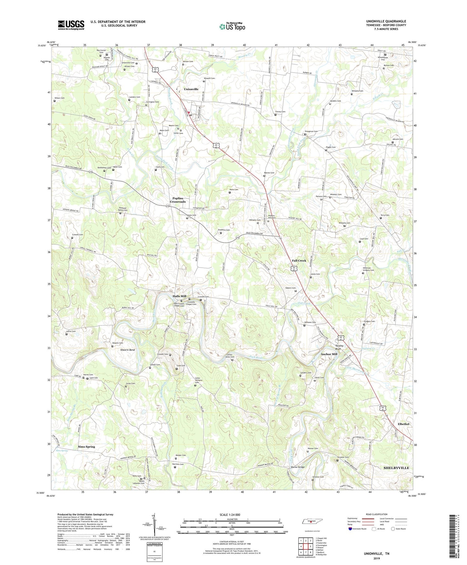
2019 topographic map quadrangle Unionville in the state of Tennessee. Scale: 1:24000. Based on the newly updated USGS 7.5' US Topo map series, this map is in the following counties: Bedford. The map contains contour data, water features, and other items you are used to seeing on USGS maps, but also has updated roads and other features. This is the next generation of topographic maps. Printed on high-quality waterproof paper with UV fade-resistant inks.
Quads adjacent to this one:
West: Farmington
Northwest: Chapel Hill
North: Rover
Northeast: Fosterville
East: Deason
Southeast: Shelbyville
South: Bedford
Southwest: Belfast
Contains the following named places: Adcock Cemetery, Alexander Creek, Allison Cemetery, Anchor Mill, Bellview Church, Bellview School, Bethlehem Cemetery, Blackburns Mill, Bounds Cemetery, Britton Ford, Burton Cemetery, Card Cemetery, Clark Cemetery, Clem Creek, Collier-Jones Cemetery, Commissioner District 3, Cook Cemetery, Covington Cemetery, Crowell Cemetery, Crowells Chapel Cemetery, Crowells Chapel Lutheran Church, Dryland Creek, El Bethel Baptist Church, Elbethel, Fall Creek, Finney Cemetery, Friendship Church, Green Hill Church, Green Hill School, Gregory Cemetery, Halls Mill, Harems Store, Harms Cemetery, Harrison Cemetery, Hickory Hill Cemetery, Hickory Hill Methodist Church, Hurricane Creek, Jones Cemetery, Landers Cemetery, Lebanon Church, Lentz Cemetery, Lentz Chapel, Lentz-Williams Cemetery, Lily Hill Church, Little Hurricane Creek, Locke Cemetery, Lowell Cemetery, Loyd Cemetery, Lucas Cemetery, Maxwell Chapel United Methodist Church, Molder Cemetery, Moon Cemetery, Moore Cemetery, Moulder School, Mount Lebanon Cemetery, North Fork Church, Old Crowell Chapel Cemetery, Osborn Cemetery, Parch Corn Creek, Parsons Cemetery, Pisgah Cemetery, Pisgah School, Pleasant Valley Cemetery, Pleasant Valley Church, Poplins Crossroads, Poplins Crossroads Census Designated Place, Potts Cemetery, Presgrove Cemetery, Ray Corner Cemetery, Reeves Cemetery, Sanders Cemetery, Sawmill Spring Branch, Shearin Bend, Shearin Cemetery, Sims Spring, Sims Spring Branch, Sinking Creek, Stephens Cemetery, Story Cemetery, Streater Cemetery, Streeter Cemetery, Tarpley Bluff, Terry Cemetery, Union Grove Church, Union School, Unionville, Unionville Cemetery, Unionville Census Designated Place, Unionville Division, Unionville First Baptist Church, Unionville Methodist Church, Unionville Post Office, Unionville School, Unionville Volunteer Fire Department, Warner Bridge, Warner Cemetery, Weakly Creek, Wheeler Cemetery, Wheelhouse Cemetery, Whites Chapel School, Whitman - Gregory Cemetery, Williams Cemetery, Wilson Cemetery, Winsett Cemetery, Wrights Store, Zion Hill United Methodist Church, ZIP Code: 37180


