MyTopo
Rockvale Tennessee US Topo Map
Couldn't load pickup availability
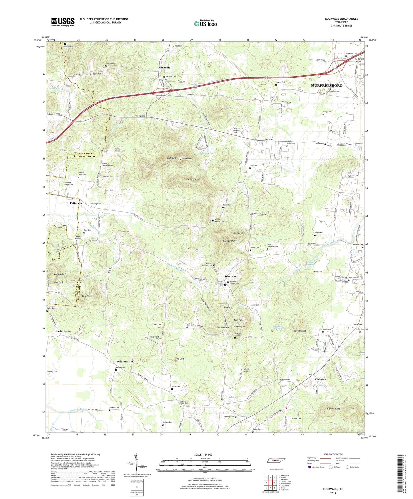
2022 topographic map quadrangle Rockvale in the state of Tennessee. Scale: 1:24000. Based on the newly updated USGS 7.5' US Topo map series, this map is in the following counties: Rutherford, Williamson. The map contains contour data, water features, and other items you are used to seeing on USGS maps, but also has updated roads and other features. This is the next generation of topographic maps. Printed on high-quality waterproof paper with UV fade-resistant inks.
Quads adjacent to this one:
West: College Grove
Northwest: Nolensville
North: Smyrna
Northeast: Walterhill
East: Murfreesboro
Southeast: Fosterville
South: Rover
Southwest: Chapel Hill
This map covers the same area as the classic USGS quad with code o35086g5.
Contains the following named places: Almaville, Almaville Fire Department Station 1, Almaville School, Baskin Cemetery, Batey Cemetery, Blackman Cemetery, Blue Sink, Bowen-Snell Cemetery, Brothers Cemetery, Burns Cemetery, Carlton Cemetery, Cedar Grove, Cedar Grove Church, Cedar Grove School, Cocke Cemetery, Cole Knob, Comer Cemetery, Commissioner District 20, Concord Creek, Crestwood, Downing Cemetery, Dyer Cemetery, Eagleville Division, Ellis Field, Fain Hill, Foxridge, Freeman Cemetery, Garrett Knob, Gibson Airport, Glen Cemetery, Glenn-Windrow Cemetery, Haley Cemetery, Harris Cemetery, Haynes Cemetery, Hill Cemetery, Indian Mountain, Jackson Cemetery, Jackson Ridge, Jackson Ridge Camp Ground, Jackson Ridge Cemetery, Jackson Ridge Church, Jarratt Cemetery, Jarrett Knob, Kelly Creek, Kingwood School, Lawrence Chapel School, Lawrence-Yeargin Cemetery, Leathers Hill, Lock School, Lockwood Lake, Love Cemetery, Lytlel-Banks Cemetery, Manire Cemetery, Manning Cemetery, McClaren-Marable Cemetery, McCord Knob, McNeil Farms, Oakwood, Overall Springs, Palmore Cemetery, Pate Cemetery, Patterson, Patterson Baptist Church, Patterson School, Pleasant Hill, Primm Cemetery, Raney Cemetery, Ransom Cemetery, Red Hill, Rehobeth Church, Rockvale, Rockvale Census Designated Place, Rockvale Church, Rockvale Elementary School, Rockvale Post Office, Rockvale Volunteer Fire Department Station 1, Rowland Hill Cemetery, Rowling Hill, Rutledge Hollow, Scales Mountain, Snail Shell Cave Spring, Snell, Snell Cemetery, Snell-Newman Cemetery, Sophie Hill, Spann Cemetery, The Gulf, Toombs Cemetery, Townsel Hill, Triune Airfield, Tucker Cemetery, Vaughan Cemetery, Wade Cemetery, Watson-Rowland Cemetery, Watson-Vaughn Cemetery, West Cemetery, Windrow, Windrow Branch, Windrow Church Cemetery, Windrow Community Cemetery, Windrows Camp Ground, Wood Cemetery, Wray-Covington Cemetery, ZIP Code: 37153