MyTopo
West Sandy Dike Tennessee US Topo Map
Couldn't load pickup availability
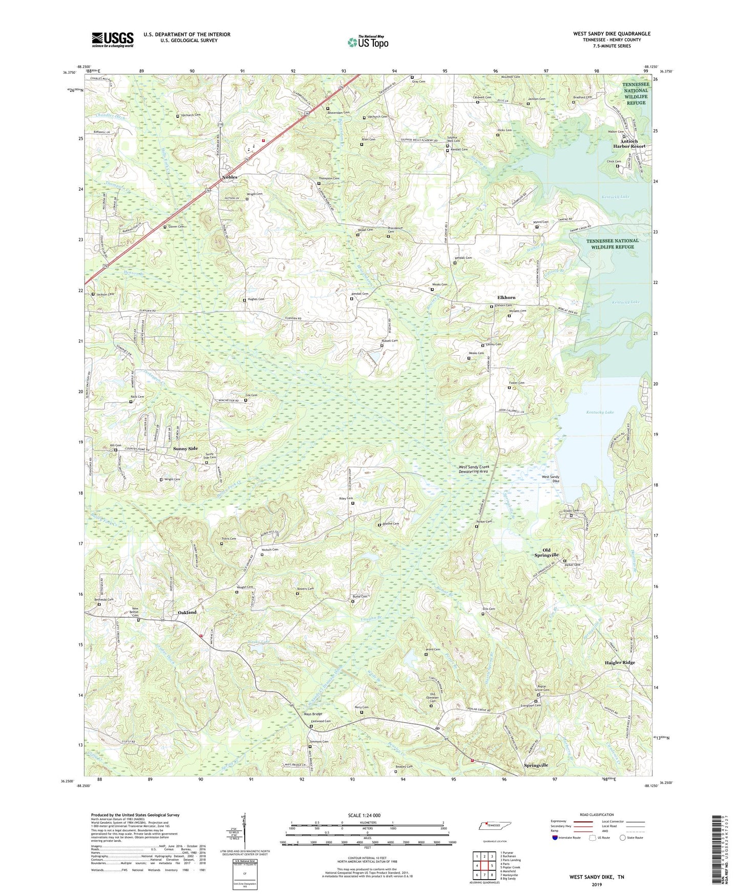
2022 topographic map quadrangle West Sandy Dike in the state of Tennessee. Scale: 1:24000. Based on the newly updated USGS 7.5' US Topo map series, this map is in the following counties: Henry. The map contains contour data, water features, and other items you are used to seeing on USGS maps, but also has updated roads and other features. This is the next generation of topographic maps. Printed on high-quality waterproof paper with UV fade-resistant inks.
Quads adjacent to this one:
West: Paris
Northwest: Puryear
North: Buchanan
Northeast: Paris Landing
East: Poplar Creek
Southeast: Big Sandy
South: Manleyville
Southwest: Mansfield
This map covers the same area as the classic USGS quad with code o36088c2.
Contains the following named places: Allen Cemetery, Antioch Harbor Resort, Bailey Fork Creek, Beasley Cemetery, Beasley Creek, Beaverdam Cemetery, Beaverdam Creek, Bethesda Cemetery, Bethesda Church, Big Sandy Unit Tennessee National Wildlife Refuge, Bomar Branch, Booth School, Boothe Cemetery, Bowers Cemetery, Bowles Branch, Bradford Cemetery, Britton Ford Campground, Burke Cemetery, Caldwell Cemetery, Camp Running Deer, Chandler Ditch, Chick Cemetery, Commissioner District 3, Conyers Branch, Cox Branch, Cox Cemetery, Easley Cemetery, Eastwood Cemetery, Elkhorn, Elkhorn Cemetery, Elkhorn Park Community Center, Elliott Cemetery, Ellis Cemetery, Evergreen Cemetery, Evergreen Church, Evergreen School, Foster Cemetery, Friendship Church, Gillooly Branch, Glover Cemetery, Gray Cemetery, Greenhead Recreation Area, Grovers Mill, Grudge Ditch, Haigler Ridge, Harris Spring Branch, Hastings Branch, Henson Branch, Hicks Cemetery, Hill Cemetery, Holly Fork Creek, Hughes Cemetery, Jackson Cemetery, John R Miller School for Retarded, Kendall Cemetery, Lebanon Church, Mays Bridge, Mays Hill Church, Mays School, New Bethel Cemetery, New Bethel Church, Nichols Cemetery, Nobles, Nobles Census Designated Place, Oakland, Oakland School, Oakland Volunteer Fire Department, Old Ebenezer Cemetery, Old Springville, Paris Golf and Country Club, Paris Landing Fire Department Station 4, Parker Bridge, Parker Cemetery, Perry Cemetery, Pleasant View Dock, Pleasant View Resort, Poplar Grove Cemetery, Poplar Grove Church, Porter Branch, Porters, Providence Cemetery, Providence School, Provo Cemetery, Ralls Cemetery, Riley Cemetery, Russell Cemetery, Simmons Cemetery, Spring Creek, Springville Branch, Springville Church, Springville Elementary School, Springville Post Office, Springville Volunteer Fire Department Station 2, Sulphur Well Academy, Sulphur Well Academy Church, Sulphur Well Cemetery, Sulphur Well Swamp, Sunny Side, Sunny Side Cemetery, Sunnyside School, Swamp Creek, Thompson Cemetery, Thompson Creek, Travis Cemetery, Turkeypen Creek, Union Church, Upchurch Cemetery, Vaughn Branch, Vaughn Cemetery, Wade Branch, Walker Branch, Walker Cemetery, Weaks Cemetery, Weaks Lake, Weaks Lake Dam, West Sandy Creek Dewatering Area, West Sandy Creek Drainage Ditch, West Sandy Dike, West Sandy Wildlife Management Area, Winsett Cemetery, Wright Cemetery, Wynns Cemetery, ZIP Code: 38256