MyTopo
Buchanan Tennessee US Topo Map
Couldn't load pickup availability
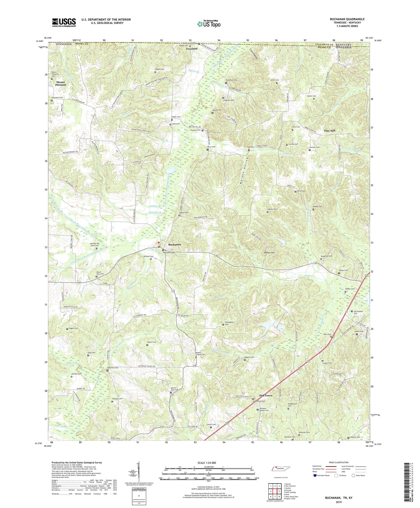
2022 topographic map quadrangle Buchanan in the state of Tennessee. Scale: 1:24000. Based on the newly updated USGS 7.5' US Topo map series, this map is in the following counties: Henry, Calloway. The map contains contour data, water features, and other items you are used to seeing on USGS maps, but also has updated roads and other features. This is the next generation of topographic maps. Printed on high-quality waterproof paper with UV fade-resistant inks.
Quads adjacent to this one:
West: Puryear
Northwest: Murray
North: New Concord
Northeast: Hamlin
East: Paris Landing
Southeast: Poplar Creek
South: West Sandy Dike
Southwest: Paris
This map covers the same area as the classic USGS quad with code o36088d2.
Contains the following named places: Beaver Dam Cemetery, Beaverdam Church, Bethel Cemetery, Big Eagle Creek Church, Blood River Church, Blood River Drainage Ditch, Blood River School, Bowden Cemetery, Bradshaw Cemetery, Brooks Cemetery, Brushy Branch, Bryant Branch, Bryant Cemetery, Buchanan, Buchanan Baptist Church, Buchanan Cemetery, Buchanan Census Designated Place, Buchanan Elementary School, Buchanan Post Office, Buchanan-Elkhorn Division, Bucy Cemetery, Chumley Cemetery, Clayton Branch, Clayton Hollow, Cooper Cemetery, Crass Hollow, Crouch Cemetery, Cullage Branch, Dale Branch, Dale Cemetery, Delno School, Edmunds Cemetery, Ferguson Branch, Ferguson Cemetery, Fisher Cemetery, Freeland, Freeland Cemetery, Heglar Chapel Cemetery, Hopkins Cemetery, Huddleston Cemetery, Hutson School, Jackson Cemetery, King Cemetery, Lax Cemetery, Linville Cemetery, Martin Cemetery, McGehee Branch, McGhee Old Slave Cemetery, McLester Cemetery, Merrill Branch, Moody Cemetery, Morgan Hollow, Mount Pleasant, Mount Pleasant Cemetery, Mount Pleasant Church, Mount Sinai Church, Mount Sinai School, Mount Vista, Mount Zion Cemetery, Mount Zion Church, Neece Cemetery, Nelson Creek, North Fork Blood River, North Fork Blood River Drainage Ditch, North Fork Eagle Creek, Oak Grove, Oak Grove Cemetery, Oak Grove Gravel Pit, Oak Grove School, Old Soldiers Cemetery, Oliver Cemetery, Owens Cemetery, Owens Hill, Paris Landing Fire Department Station 2, Patterson Cemetery, Perry Cemetery, Pine Hill, Pine Hill School, Point Pleasant School, Rabbit Creek, Redtop School, Roberts Cemetery, Rocky Branch, Rogers Cemetery, Salmon Cemetery, South Fork Blood River, South Fork Blood River Drainage Ditch, South Fork Eagle Creek, Townley Cemetery, Valentine Cemetery, Williams Cemetery, Williams-Nathan Cemetery, Willoughby Cemetery, Wilson Cemetery, ZIP Code: 38222