MyTopo
Stephenville Texas US Topo Map
Couldn't load pickup availability
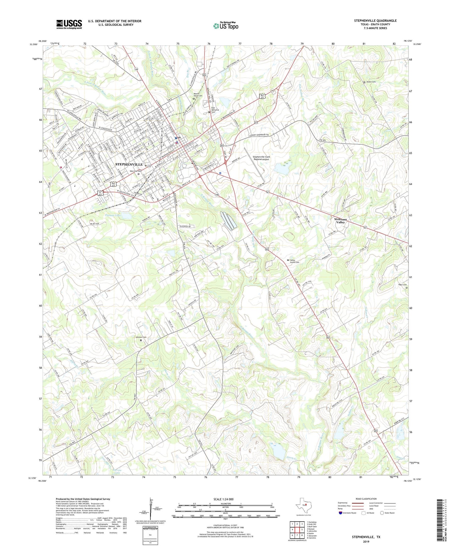
2022 topographic map quadrangle Stephenville in the state of Texas. Scale: 1:24000. Based on the newly updated USGS 7.5' US Topo map series, this map is in the following counties: Erath. The map contains contour data, water features, and other items you are used to seeing on USGS maps, but also has updated roads and other features. This is the next generation of topographic maps. Printed on high-quality waterproof paper with UV fade-resistant inks.
Quads adjacent to this one:
West: Bunyan
Northwest: Huckabay
North: Knob Hill
Northeast: Bluff Dale
East: Johnsville
Southeast: Clairette
South: Alexander
Southwest: Dublin
This map covers the same area as the classic USGS quad with code o32098b2.
Contains the following named places: Alive in Christ Fellowship Church, Allard Cemetery, Berry House, Central Elementary School, Central Ward School, Chamberlain Ward School, Chamberlin Elementary School, Church of Christ, Church of Christ Bible Chair, City of Stephenville, Cross Timbers Baptist Church, Cross Timbers Church of Christ, Dry Branch, East Memorial Cemetery, Erath County, Erath County Constable's Office Precinct 1, Erath County Constable's Office Precinct 2, Erath County Constable's Office Precinct 3, Erath County Constable's Office Precinct 4, Erath County Courthouse, Erath County Emergency Medical Services, Erath County Jail, Erath County Sheriff's Office, First Baptist Church, First Presbyterian Church, Grace Fellowship Church, Indian Creek, Indian Creek Cemetery, Johnson Cemetery, KSTV-AM (Stephenville), Kyle Dam, Kyle Lake, Memorial Stadium, Mount Olive Cemetery, North Fork North Bosque River, Oakdale United Methodist Church, Ogan Cemetery, Pittman Lake, Pittman Lake Dam, Pleasant Hill Church, Pole Hollow Branch, Provident Church, Rocky Point Church, Saint Brendans Catholic Church, Saint Lukes Episcopal Church, Seventh Day Adventist Church, Soil Conservation Service Site 15 Dam, Soil Conservation Service Site 15 Reservoir, Soil Conservation Service Site 17 Dam, Soil Conservation Service Site 17 Reservoir, Soil Conservation Service Site 18 Dam, Soil Conservation Service Site 18 Reservoir, Soil Conservation Service Site 7 Dam, Soil Conservation Service Site 7 Reservoir, South Fork North Bosque River, Stephenville, Stephenville City Hall, Stephenville City Park, Stephenville Clark Regional Airport, Stephenville Division, Stephenville Fire Department Station 1, Stephenville Fire Department Station 2, Stephenville High School, Stephenville Historical House Museum, Stephenville Intermediate School, Stephenville Junior High School, Stephenville Police Department, Stephenville Post Office, Summer Sky - Chemical Dependency Treatment Center, Summer Sky Alternative School, Tarleton State College Farm, Texas Health Harris Methodist Hospital Stephenville, Valley Grove Cemetery, Valley Grove Church, Victory Baptist Church, Washington Street Baptist Church, Welcome Valley, West End Cemetery, Wyatt-Hickie Ranch Complex, ZIP Code: 76402