MyTopo
Van Alstyne Texas US Topo Map
Couldn't load pickup availability
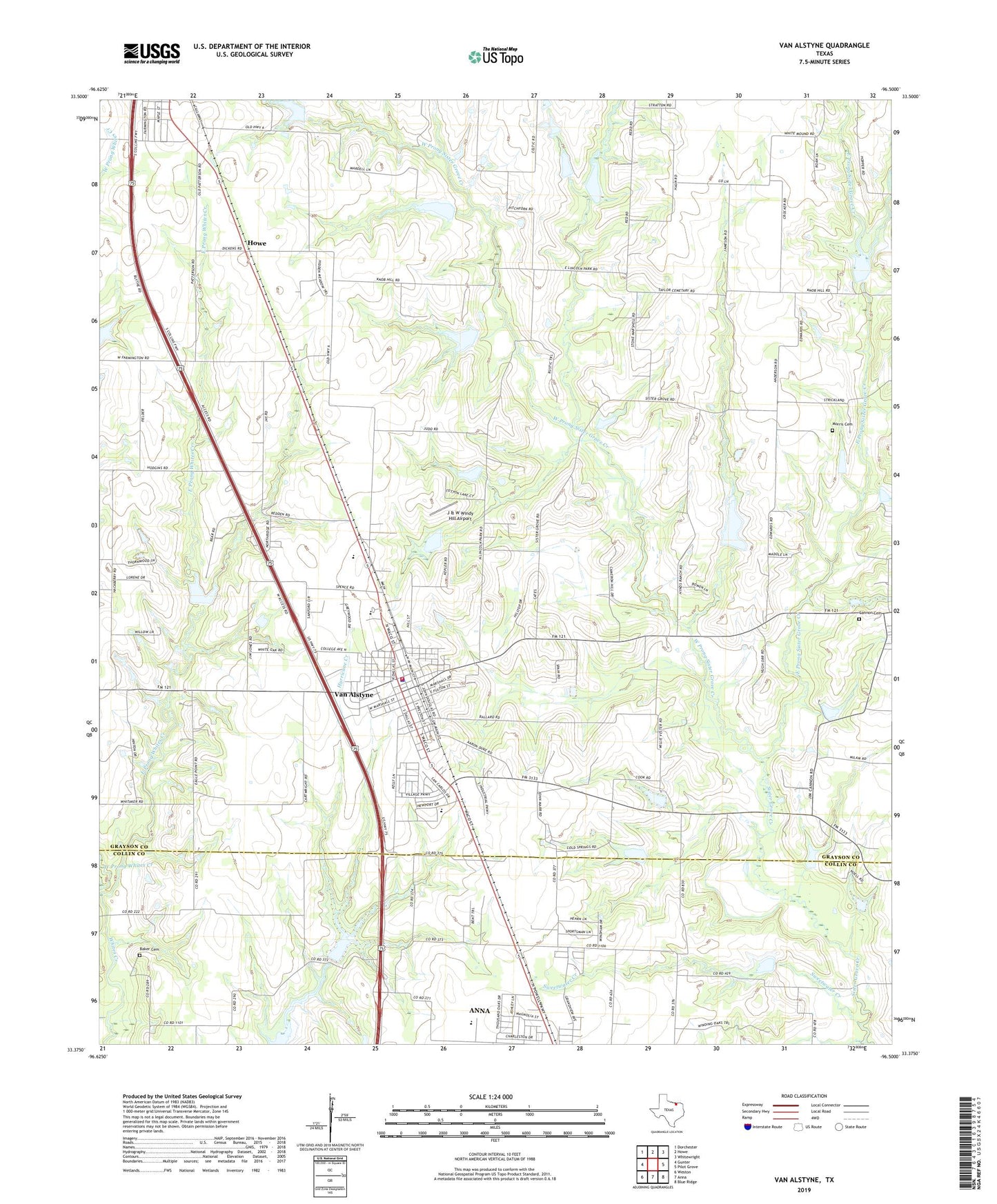
2022 topographic map quadrangle Van Alstyne in the state of Texas. Scale: 1:24000. Based on the newly updated USGS 7.5' US Topo map series, this map is in the following counties: Grayson, Collin. The map contains contour data, water features, and other items you are used to seeing on USGS maps, but also has updated roads and other features. This is the next generation of topographic maps. Printed on high-quality waterproof paper with UV fade-resistant inks.
Quads adjacent to this one:
West: Gunter
Northwest: Dorchester
North: Howe
Northeast: Whitewright
East: Pilot Grove
Southeast: Blue Ridge
South: Anna
Southwest: Weston
This map covers the same area as the classic USGS quad with code o33096d5.
Contains the following named places: Baker Cemetery, Cannon Cemetery, City of Van Alstyne, East Prong Sister Grove Creek, East Prong Whites Creek, Grayson County Constable's Office Precinct 4, J & W Windy Hill Airport, Mantua Cemetery, Morris Cemetery, Sister Grove Church, Soil Conservation Service Site 1 Dam, Soil Conservation Service Site 1 Reservoir, Soil Conservation Service Site 19 Dam, Soil Conservation Service Site 19 Reservoir, Soil Conservation Service Site 2 Dam, Soil Conservation Service Site 2 Reservoir, Soil Conservation Service Site 20 Dam, Soil Conservation Service Site 20 Reservoir, Soil Conservation Service Site 21 Dam, Soil Conservation Service Site 21 Reservoir, Soil Conservation Service Site 22 Dam, Soil Conservation Service Site 22 Reservoir, Soil Conservation Service Site 23 Dam, Soil Conservation Service Site 23 Reservoir, Soil Conservation Service Site 24 Dam, Soil Conservation Service Site 24 Reservoir, Soil Conservation Service Site 25 Dam, Soil Conservation Service Site 25 Reservoir, Soil Conservation Service Site 28 Dam, Soil Conservation Service Site 28 Reservoir, Soil Conservation Service Site 29 Dam, Soil Conservation Service Site 29 Reservoir, Soil Conservation Service Site 30 Dam, Soil Conservation Service Site 30 Reservoir, Soil Conservation Service Site 31 Dam, Soil Conservation Service Site 31 Reservoir, Soil Conservation Service Site 32 Dam, Soil Conservation Service Site 32 Reservoir, Soil Conservation Service Site 34 Dam, Soil Conservation Service Site 34 Reservoir, Soil Conservation Service Site 35 Dam, Soil Conservation Service Site 35 Reservoir, Soil Conservation Service Site 36 Dam, Soil Conservation Service Site 36 Reservoir, Soil Conservation Service Site 37 Dam, Soil Conservation Service Site 37 Reservoir, Soil Conservation Service Site 39 Dam, Soil Conservation Service Site 39 Reservoir, Soil Conservation Service Site 42 Dam, Soil Conservation Service Site 42 Reservoir, Soil Conservation Service Site 5 Dam, Soil Conservation Service Site 5 Reservoir, Sweetwater Creek, Umphress-Taylor House, Van Alstyne, Van Alstyne City Hall, Van Alstyne Fire Department, Van Alstyne Historical Museum, Van Alstyne Police Department, Van Alstyne Post Office, Van Alstyne Sewage Disposal, West Prong Sister Grove Creek, West Prong Whites Creek, ZIP Code: 75495